Notes: This obscure station took its name from the junction where a mineral line diverged from the East Coast main line towards Ashington Colliery, about two miles east. Unusually for such a meticulously researched publication Clinker’s Register inaccurately placed the station at Ashington (on the Bedlington-Newbiggin branch) and the error has been replicated in other publications.
 An authoritative source on mining history gives the opening date of Ashington Colliery as 1867, but a settlement of this name is shown on a large scale OS plan surveyed in 1859, linked by a ‘wagonway’ to the East Coast main line. Close to the terminus of the branch an engine house is named – presumably associated with a small coal pit - and adjacent to it the map indicates that there is a platform. The same map identifies the point where the wagonway meets the main line as ‘Ashington Colliery Junction’, but no platform is shown here. An authoritative source on mining history gives the opening date of Ashington Colliery as 1867, but a settlement of this name is shown on a large scale OS plan surveyed in 1859, linked by a ‘wagonway’ to the East Coast main line. Close to the terminus of the branch an engine house is named – presumably associated with a small coal pit - and adjacent to it the map indicates that there is a platform. The same map identifies the point where the wagonway meets the main line as ‘Ashington Colliery Junction’, but no platform is shown here.
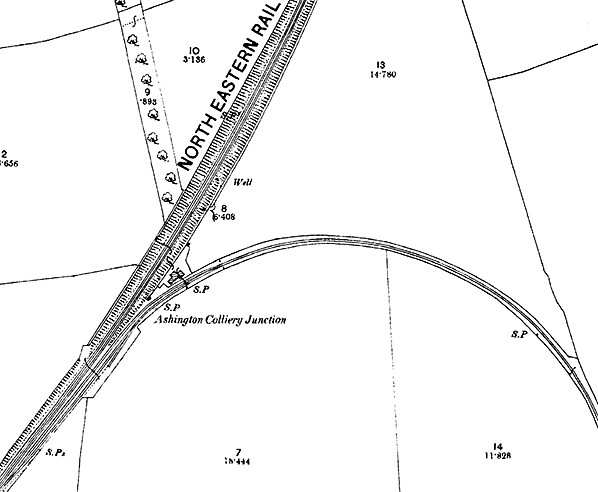
Ashington Colliery Junction had no road access so trains stopped here probably for the convenience of railway staff – there was a signal box at the junction by 1873 - and for workers at the colliery when there was insufficient housing in the locality; the existence of a platform at Ashington Colliery suggests that workers were carried on the ‘wagonway’. On the Ordnance Survey plan of 1856 the only building close to what must have been the Ashington Colliery Junction station site, is a weigh house in the apex between the ECML and the mineral line to Ashington. It is not known whether a platform or any buildings were ever provided for passengers at the junction.
The earliest record found of Ashington Colliery Junction station is in a working timetable of December 1871, but it also appeared inconspicuously in public timetables in that decade. In May 1877 the only train shown in Bradshaw to call at Ashington Colliery Junction was on Saturday, when the 3.30pm from Newcastle, which ran only as far as Morpeth on Monday-to-Friday, was extended to Tweedmouth, and the station appeared as a column note. In August 1878 Ashington Colliery Junction made its final appearance in the timetable.
There are no remains of the former station at the site. The 12-lever Ashington Colliery signal box, on the up side of the main line, closed in 1907. Its replacement, known as ‘Ashington Junction’ and renamed ‘Ashington Colliery’ in 1930, was a timber structure with 20 levers, also east of the main line; it closed on 9 March 1939.
In June 1878, only weeks before Ashington Colliery Junction disappeared from the timetable, a station - initially called ‘Hirst’ - opened on the Newbiggin branch. The timing is surely no coincidence, and it can be assumed that this new station made Ashington Colliery Junction station redundant. Hirst station was only several hundred yards from the large Ashington Colliery which opened in 1867; this new colliery was about half-a-mile east of the earlier mine. The new station was also close to the many terraced streets of miners’ cottages which developed to form what claimed to be the largest ‘village’ in Britain, known as Ashington; Hirst station was given this name in 1889. Ashington Colliery was to possess a private railway system, which also served other pits owned by the Ashington Coal Company.
The platform shown at the settlement of Ashington Colliery on the 1856 OS map still appears on a map dated 1895, which was not fully revised, but it is no longer shown on the 1897 map when the ‘wagonway’ has been realigned to serve the new colliery.
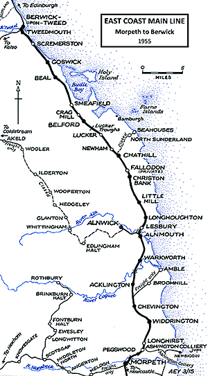
Route maps drawn by Alan Young.
Click here for a brief history of the East Coast Main Line
in Northumberland.
Click any of the following names to see the pages for the Ashington Coal Company (later National Coal Board) railway: Hirst Platform, New Moor, Linton Colliery & Ellington Colliery. Also see Ashington (NER/LNER/BR)
See other ECML stations: Tweedmouth, Scremerston, Goswick, Beal, Smeafield, Crag Mill, Belford, Lucker,
Newham, Fallodon, Little Mill,
Christon Bank, Longhoughton, Lesbury, Warkworth, Longhirst, Morpeth, Stannington, Plessey, Annitsford (1st), Annitsford (2nd), Killingworth, Forest Hall, Heaton (2nd), Heaton (1st), Durham, Croft Spa, Eryholme, Otterington, Alne & Tollerton |

colliery_junction1.jpg) A driver’s view looking north-east towards the site of Ashington Colliery Junction in July 2015. The mineral line to Ashington Colliery curved away to the right between the second and third catenary mast.
A driver’s view looking north-east towards the site of Ashington Colliery Junction in July 2015. The mineral line to Ashington Colliery curved away to the right between the second and third catenary mast.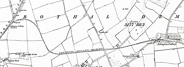
colliery_junction2.jpg)

 Home Page