Note: The 1938 OS map shows no buildings on the site. New Moor was a ventilation shaft for Ashington Colliery, but fitted with a Koepe-winder which was designed for very deep mines and introduced in 1954. It may be that the shaft was sunk in 1954 for this winder, but it is not known when it actually opened.
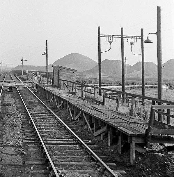
This was one of four stopping places on the 20-mile Ashington Coal Company (later National Coal Board) system. The halt had platforms approximately 150ft in length, the ‘down’ (northbound) situated to the north of the level crossing and the ‘up’ south of the crossing. Each platform had a small shelter. A signal box stood immediately north of the crossing, east of the line.
The halt gave access to a network of sidings south of the A1068. New Moor was a man-riding shaft for Ashington. It had pit-head baths, but no other substantial buildings. The paddy trains took the miners to and from Ashington who went underground at New Moor.
Before World War I the NER loaned a locomotive and crew from North Blyth depot to operate the services on the system, but later the Ashington Coal Company had its own tank engines and rolling stock which provided the passenger train service until 15 May 1966. After this date contract buses were provided instead. New Moor closed with Ashington Colliery in October 1986.
The track through New Moor was lifted c. 2011 but the line north of New Moor has been reopened and upgraded to take 100-ton bogie coal hoppers. It serves a small opencast site from which coal is carried by conveyor to the loading pad known as Potland Burn Disposal Site. It currently employs an ex-BR class 08 shunter from Widdrington opencast. Potland Burn is reached via a new connection to the East Coast main line, built in the 1980s.
Click here to see a film of a freight train travelling between the crossing at Potland and the present end of the line at New Moor in February 2012.
BRIEF HISTORY OF THE ASHINGTON COAL COMPANY (later NCB) RAILWAYS
The Ashington Coal Company operated pits at Ashington, Linton, Ellington, Woodhorn and (from 1934) Lynemouth. In 1947 the company’s pits became part of the nationalised coal industry (the National Coal Board).
From 1880 a 2ft gauge line operated to carry miners from Ashington to Pegwood Colliery. In 1895 this was abandoned in favour of the standard gauge network as this expanded, though not between Ellington and Lynemouth or Ashington and Woodhorn. The service was operated by the colliery company using a variety of ex-railway company stock, from four- and six-wheel coaches, eventually to bogie stock. On occasions before World War I the NER provided a locomotive and crew from their North Blyth depot when a colliery locomotive was not available.
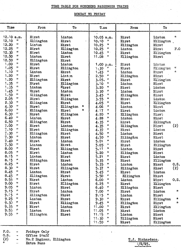
The so-called ‘Paddy trains’ began from Hirst Platform, named after the hamlet around which the town of Ashington grew. A 24-hour, 7-days a week service was operated, with about 100 trains on each weekday, 70 on Saturdays and 45 on Sundays. Besides the miners the trains also carried fare-paying passengers at a very cheap rate, whilst children paid half fare, unless going to school, when they travelled free. Paper tickets were issued, with a different colour for each day.
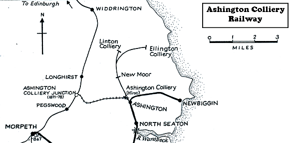 |
JA loco shed served the system. It was located close to Ashington Colliery at NZ 263881. At ‘vesting day’ when Ashington Coal Company became part of the National Coal Board the system ran from Ashington Colliery northwards for 2½ miles (double-track) to Linton Colliery, where the railway’s workshops were situated. Just south of the colliery was Potland unction, whence a further double track section ran north-eastwards for 1½ miles to Ellington Colliery, followed by a single line of 2 miles to Lynemouth Colliery.
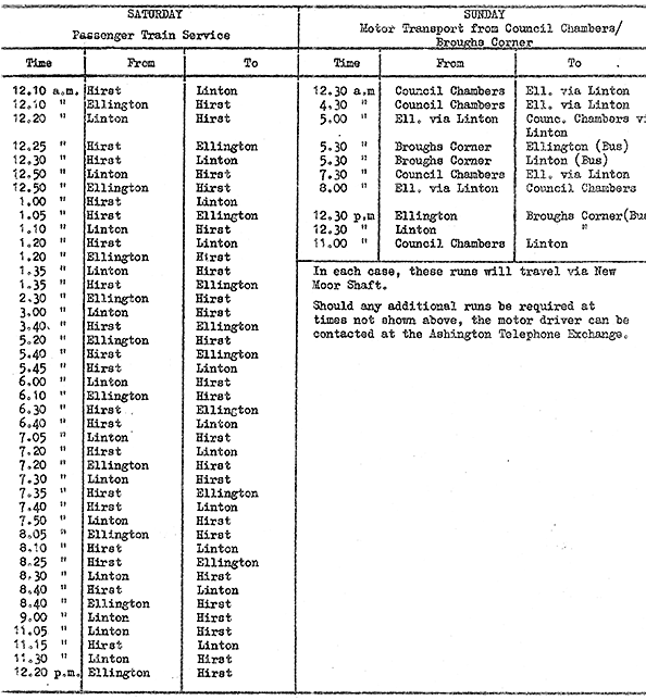
The line was fully signalled and track circuited to allow British Railways’ locomotives to work over the system. North of the terminus at Hirst Platform, trains served New Moor platform, about 1 mile north-north-west, and Linton; alternatively trains operated between Hirst and Ellington. The NCB soon stopped carrying children and the general public, limiting the service to miners only. In 1965, the year before the service was withdrawn, 95 journeys were run on weekdays and 43 on Saturdays.
The ‘Paddy train’ service was discontinued on 16 May 1966 and replaced with contract buses. All of the pits belonging to the former Ashington Coal Company have now closed.
Click here for a list of sources and a Blyth & Tyne bibliography
Ticket from Michael Stewart. Route map drawn by Alan Young, Timetable from Glen Kilday
To see other stations on the Ashington Colliery Railway click on the station name: Hirst Platform (Ashington Colliery), Linton Colliery & Ellington Colliery |

moor_old1.jpg)
moor.gif)
moor_old2.jpg)
moor10.jpg)
moor11.jpg)
moor3.jpg)
moor4.jpg)
moor_thumb7.jpg)
moor_thumb8.jpg)
moor_thumb9.jpg)
moor_thumb1.jpg)
moor_thumb2.jpg)
moor_thumb5.jpg)
moor_thumb6.jpg)

 Home Page