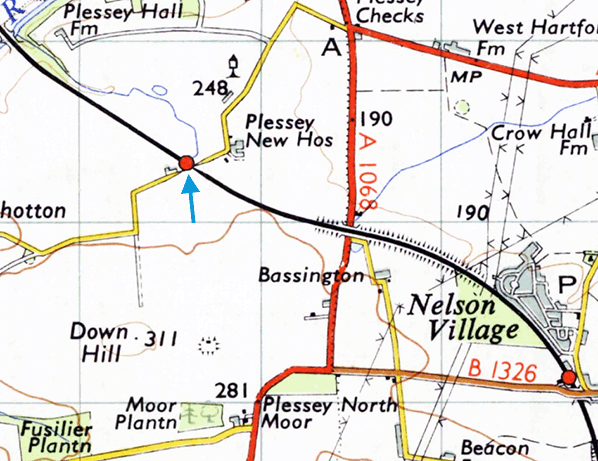
 Notes: Plessey is at the very margin of the deep coal mining area of south-east Northumberland. Small coal mines operated near Plessey Checks and New Houses, but they had ceased production by the early nineteenth century and they left little trace on the landscape. Numerous larger shaft mines with their attendant pit-heaps (the man-made mountains of waste materials) and sprawling villages of terraced housing dominated the landscape as close as Cramlington and Dudley, but into the twentieth century Plessey remained a rural agricultural area with scattered farmsteads. In the station’s later days some opencast mining was carried out a short distance to the north and south – see the OS 1953 map; and since the station closed, the rural isolation has been lost as further opencast coal mining and the expansion of Cramlington’s industrial estates have transformed the landscape. Only to the north are there still quiet fields. There is now no village of Plessey, but a ‘deserted medieval village’ site has been identified about ¾-mile north-west of the former station, just east of Plessey Hall Farm. The name is carried by a few other buildings in the locality as well as by the attractive Plessey Woods (now a Country Park) in the valley of the River Blyth over which the East Coast main line passes on a viaduct. Notes: Plessey is at the very margin of the deep coal mining area of south-east Northumberland. Small coal mines operated near Plessey Checks and New Houses, but they had ceased production by the early nineteenth century and they left little trace on the landscape. Numerous larger shaft mines with their attendant pit-heaps (the man-made mountains of waste materials) and sprawling villages of terraced housing dominated the landscape as close as Cramlington and Dudley, but into the twentieth century Plessey remained a rural agricultural area with scattered farmsteads. In the station’s later days some opencast mining was carried out a short distance to the north and south – see the OS 1953 map; and since the station closed, the rural isolation has been lost as further opencast coal mining and the expansion of Cramlington’s industrial estates have transformed the landscape. Only to the north are there still quiet fields. There is now no village of Plessey, but a ‘deserted medieval village’ site has been identified about ¾-mile north-west of the former station, just east of Plessey Hall Farm. The name is carried by a few other buildings in the locality as well as by the attractive Plessey Woods (now a Country Park) in the valley of the River Blyth over which the East Coast main line passes on a viaduct.
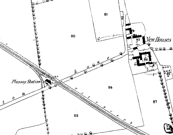
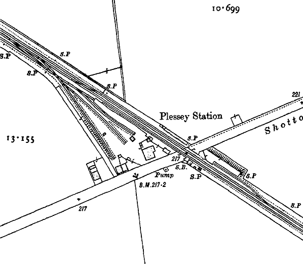
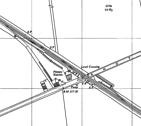
 When the Newcastle & Berwick Railway opened in 1847 a handsome building was provided immediately north-west of the Shotton Lane level crossing, on the down side of the double track, where Plessey station was later to open. The building was similar to that at Forest Hall which, like Plessey, did not operate as a timetabled passenger station until the 1850s, and it was larger than most of the crossing-keepers’ cottages so the intention might have been to handle goods traffic there or eventually convert it to serve as a fully-fledged station. It is likely that platforms were installed to allow market trains to call prior to the appearance of the station in Bradshaw of July 1859. Early public timetables gave the name as ‘Plessy’; the working timetable called it ‘Plessay’. From 1864 the spelling ‘Plessey’ was used. When the Newcastle & Berwick Railway opened in 1847 a handsome building was provided immediately north-west of the Shotton Lane level crossing, on the down side of the double track, where Plessey station was later to open. The building was similar to that at Forest Hall which, like Plessey, did not operate as a timetabled passenger station until the 1850s, and it was larger than most of the crossing-keepers’ cottages so the intention might have been to handle goods traffic there or eventually convert it to serve as a fully-fledged station. It is likely that platforms were installed to allow market trains to call prior to the appearance of the station in Bradshaw of July 1859. Early public timetables gave the name as ‘Plessy’; the working timetable called it ‘Plessay’. From 1864 the spelling ‘Plessey’ was used.
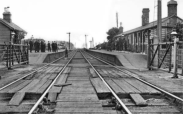
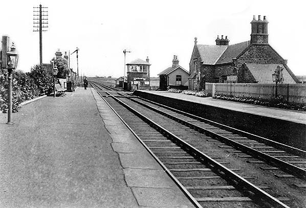
The main building was distinctively Newcastle & Berwick in style. It was of two storeys, constructed of sandstone ashlar. A gabled section facing the platform boasted a canted bay on the ground floor, and a ball finial provided decoration above the raised gable. Prominent triple chimneystacks were at the north-west and south-east ends of the building. A small pitched-roofed timber building was added adjacent to the crossing. On the opposite (up) platform, again adjoining the crossing, was a lengthy single-storey timber building with a pitched roof, which contained waiting facilities. Throughout its life the station was oil-lit. By March 1874 a signal box had been built on the down side, south-east of the level crossing.
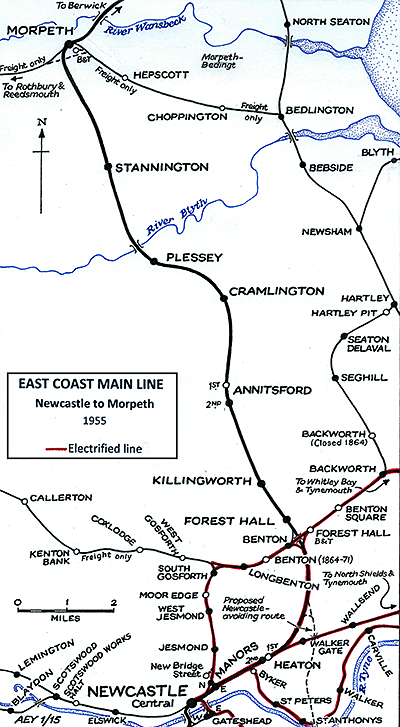
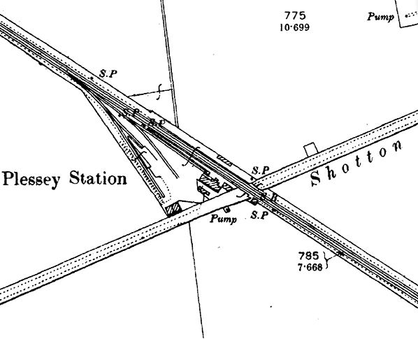
Two sidings were shown at Plessey in the LNER diagram of the line drawn in 1934. One had a trailing junction with the up line south-east of the level crossing, while the other was north-west of the crossing, having a trailing junction with the down line and a headshunt.
Bradshaw of February 1863 shows the following departures from ‘Plessy’ station:
Up trains: weekdays |
Destination |
Down trains: weekdays |
Destination |
8.41am |
Newcastle |
9.32am |
Berwick |
8.57am (Saturday only) |
Newcastle |
1.52pm |
Berwick |
2.16pm |
Newcastle |
4.02pm (Saturday only) |
Widdrington |
7.57pm |
Newcastle |
7.02pm |
Berwick |
Up trains: Sunday |
Destination |
Down trains: Sunday |
Destination |
8.40am |
Newcastle |
6.57pm |
Berwick |
Considering that so few potential passengers lived in the vicinity of the station (only 394 in an NER report of 1911) for several decades it enjoyed a frequency of train departures broadly similar to Stannington, Cramlington, Annitsford, Killingworth and Forest Hall. In 1911 only 6,342 tickets were booked at Plessey. NER official figures for 1913 indicate that 22 wagons of livestock were loaded at the station but that there was no other significant goods traffic.
The North Eastern Railway winter 1912-13 timetable for Plessey:
Up trains: weekdays |
Destination |
Down trains: weekdays |
Destination |
7.16am |
Newcastle |
8.35am |
Beal |
8.09am |
Newcastle |
11.00am |
Alnwick |
9.08am |
Newcastle |
1.10pm |
Morpeth |
11.01am (Saturday only) |
Newcastle |
2.05pm |
Alnwick |
11.35am |
Newcastle |
2.59pm |
Morpeth |
1.56pm |
Newcastle |
4.48pm |
Morpeth |
3.19pm (Saturday only) |
Newcastle |
7.05pm |
Alnwick |
3.52pm |
Newcastle |
9.07pm |
Alnwick |
5.56pm |
Newcastle |
9.52pm (Saturday only) |
Longhirst |
7.52pm |
Newcastle |
11.50pm (Tue, Thu, Sat only) |
Morpeth |
9.59pm |
Newcastle |
|
|
Up trains: Sunday |
Destination |
Down trains: Sunday |
Destination |
8.34am |
Newcastle |
8.34am |
Berwick |
8.26pm |
Newcastle |
3.06pm |
Morpeth |
|
|
7.10pm |
Berwick |
In 1923 at the ‘Grouping’ Plessey station was transferred from NER to London & North Eastern Railway administration. The LNER’s major contribution to the station’s appearance was the installation of standard wooden running-in nameboards with relief metal lettering.
In winter 1937-38 Plessey still enjoyed a relatively frequent service, but at irregular intervals. However, by this time some of the trains which called at other minor stations did not stop at Plessey.
Up trains: weekdays |
Destination |
Down trains: weekdays |
Destination |
7.11am |
Newcastle |
8.46am |
Beal |
8.04am |
Newcastle |
10.39am |
Alnwick |
11.44am |
Newcastle |
1.09pm |
Morpeth |
1.01pm |
Newcastle |
2.09pm |
Alnwick |
2.01pm |
Newcastle |
4.41pm |
Morpeth |
5.11pm (Sat only) |
Newcastle |
6.29pm |
Morpeth |
6.26pm (Sat excepted) |
Newcastle |
9.30pm (Sat excepted) |
Morpeth |
8.11pm |
Newcastle |
9.30pm (Sat only) |
Alnwick |
9.44pm (Sat only) |
Newcastle |
|
|
Up trains: Sunday |
Destination |
Down trains: Sunday |
Destination |
8.21am |
Newcastle |
8.36am |
Berwick |
7.42pm |
Newcastle |
7.06pm |
Berwick |
In June 1943 Bradshaw shows the following departures from Plessey; after the outbreak of war the service was markedly reduced, but Plessey did not close, as was the fate of several main line roadside stations further north in Northumberland.
Up trains: weekdays |
Destination |
Down trains: weekdays |
Destination |
7.15am |
Newcastle |
8.51am [B] |
Alnwick |
8.26am [B] |
Newcastle |
1.47pm [B] |
Alnwick |
11.05am |
Newcastle |
10.06pm [B] |
Alnwick |
5.11pm [B] |
Manors North |
|
|
Up trains: Sunday |
Destination |
Down trains: Sunday |
Destination |
8.36am |
Newcastle |
8.06am |
Berwick |
7.38pm |
Newcastle |
7.01pm |
Berwick |
In the above table, trains noted [B] travel via Benton.
 Nationalisation of the railways on 1 January 1948 brought Plessey into British Railways’ North Eastern Region. In winter 1950-51 its train service on weekdays was little changed from wartime, save for an extra morning northbound departure, but in 1950 trains ceased to call on Sunday. This rural station (which had issued only 2,376 tickets in 1936) was unstaffed from 8 July 1951, although ‘Halt’ was not officially added to its name; the change of status probably explains the absence of ticket booking statistics for Plessey in 1951 and coincided with a reduction in its train service. The winter 1951-52 timetable shows only one up departure, to Newcastle, at 8.24am and one down, to Berwick, at 7.50am. The following summer saw a reduction in service at the neighbouring minor stations. From September 1955 Plessey’s solitary departure was northbound at 7.50am on weekdays, which was probably for parcels rather than passenger traffic. The station closed to passengers on 15 September 1958 together with many other minor stations between Newcastle and Berwick. Nationalisation of the railways on 1 January 1948 brought Plessey into British Railways’ North Eastern Region. In winter 1950-51 its train service on weekdays was little changed from wartime, save for an extra morning northbound departure, but in 1950 trains ceased to call on Sunday. This rural station (which had issued only 2,376 tickets in 1936) was unstaffed from 8 July 1951, although ‘Halt’ was not officially added to its name; the change of status probably explains the absence of ticket booking statistics for Plessey in 1951 and coincided with a reduction in its train service. The winter 1951-52 timetable shows only one up departure, to Newcastle, at 8.24am and one down, to Berwick, at 7.50am. The following summer saw a reduction in service at the neighbouring minor stations. From September 1955 Plessey’s solitary departure was northbound at 7.50am on weekdays, which was probably for parcels rather than passenger traffic. The station closed to passengers on 15 September 1958 together with many other minor stations between Newcastle and Berwick.
 In the winter 1958-59 timetable Plessey disappeared. For some years North Eastern Region timetables had acknowledged the closure of stations and advised disconsolate passengers of the bus companies whose services could be used; but the many closures went unrecorded in the winter 1958-59 book, and the next few editions continued this unfortunate practice. The regional map folded into the timetable had presumably had been printed earlier and still showed Forest Hall, Killingworth and Annistsford, but with Plessey and the other stations that closed at the same time erased. Perhaps the closure of the three which were not erased was confirmed later than their neighbours? In the winter 1958-59 timetable Plessey disappeared. For some years North Eastern Region timetables had acknowledged the closure of stations and advised disconsolate passengers of the bus companies whose services could be used; but the many closures went unrecorded in the winter 1958-59 book, and the next few editions continued this unfortunate practice. The regional map folded into the timetable had presumably had been printed earlier and still showed Forest Hall, Killingworth and Annistsford, but with Plessey and the other stations that closed at the same time erased. Perhaps the closure of the three which were not erased was confirmed later than their neighbours?
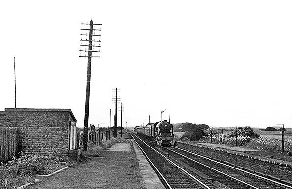
Goods traffic was dealt with at Plessey until 2 April 1962. Two months later the signal box was downgraded to a gate box (released by Stannington signal box). The platforms and buildings had been demolished by the mid 1960s. In September 1977 the crossing gates were replaced with barriers, and from August 1979 only pedestrians were permitted to cross the line here. The crossing has subsequently been extinguished.
A more famous Plessey?
The name ‘Plessey’ may be familiar to many readers, not as an obscure location in Northumberland, but as the name of the British-based electronics, telecommunications and defence company established in 1917 which merged into BAE Systems in 1999. The company’s name is directly derived from Plessey in Northumberland. There was a coincidence that not only was one of the shareholders of the firm named Plessey, but Elizabeth, the wife of the German founder of the firm William Oscar Heyme, came from the locality of Plessey in Northumberland. The name was a good one for the company to adopt because it could be pronounced in any language, it sounded well and left the scope of the company open. The word Plessey itself is a place name of Old French origin. It occurs in a number of forms - Plessis in Brittany, and notably Pleshey in Essex, which means ‘place enclosed by a hedge of plashed or pleached’, that is, interwoven branches. Source: www.britishtelephones.com/histples.htm
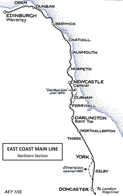
Click here for a brief history of the East Coast Main Line
in Northumberland.
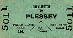
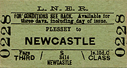
Route maps drawn by Alan Young. Tickets from Michael Stewart.
BIBLIOGRAPHY:
- Addyman, John F (Editor) A history of the Newcastle & Berwick Railway (North Eastern Railway Association, 2011) – especially Chapter 5 ‘The buildings’ by Bill Fawcett
- Biddle, Gordon Victorian stations (David & Charles, 1973)
- Biddle, Gordon Britain’s historic railway buildings (Oxford University Press, 2003)
- Fawcett, Bill A history of North Eastern Railway architecture Vol 1: The Pioneers (North Eastern Railway Association 2001)
- Young, Alan Railways in Northumberland (Martin Bairstow, 2003)
- Quick, Michael Railway passenger stations in Great Britain: a chronology (RCTS 2009)
- Clinker, C R Clinker’s register of closed passenger stations and goods depots (Avon Anglia 1978)
See other ECML stations: Tweedmouth, Scremerston, Goswick, Beal, Smeafield, Crag Mill, Belford, Lucker,
Newham, Fallodon, Little Mill, Christon Bank,
Longhoughton, Lesbury, Warkworth, Longhirst, Ashington Colliery Junction, Morpeth, Stannington, Plessey, Annitsford (1st), Annitsford (2nd), Killingworth, Forest Hall, Heaton (2nd), Heaton (1st), Durham, Croft Spa, Eryholme, Otterington, Alne & Tollerton |

1.jpg)
2.jpg)
3.jpg)
4.jpg)
5.jpg)
thumb4.jpg)
thumb6.jpg)
thumb7.jpg)

 Home Page