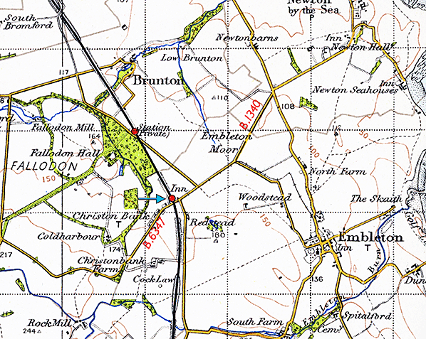
Notes: The Newcastle & Berwick Railway passed only a mile west of the large village of Embleton, but the station was given the name Christon Bank, after a farmstead about a quarter of a mile to the south. Had the station been called Embleton, the North Eastern Railway – the company which owned the station from 1854 – would perhaps have chosen to change its name because the Cockermouth, Keswick & Penrith Railway opened an Embleton station in 1865, and the NER usually showed an aversion to any of its stations sharing a name with another on its own or any other company’s lines. Although the station name was officially ‘Christon Bank’ – two words – in railway annals, and the Ordnance Survey used this form for the name of the village which developed close to the station, OS maps gave the station name as ‘Christonbank’, which was also how they rendered the farmstead’s name until the 1970s.
 The station was opened with the line on 1 July 1847 and it was given a handsome and commodious Tudor/Jacobean (‘Jacobethan’) building which bore a strong family likeness to the other stations that Benjamin Green’s designed for the N&B Railway. The structure particularly resembled the buildings at Killingworth, which cost £1,129 to construct and Acklington (£1,085) while Christon Bank’s building cost a remarkably similar £1,135. The station was opened with the line on 1 July 1847 and it was given a handsome and commodious Tudor/Jacobean (‘Jacobethan’) building which bore a strong family likeness to the other stations that Benjamin Green’s designed for the N&B Railway. The structure particularly resembled the buildings at Killingworth, which cost £1,129 to construct and Acklington (£1,085) while Christon Bank’s building cost a remarkably similar £1,135.
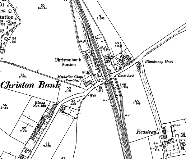
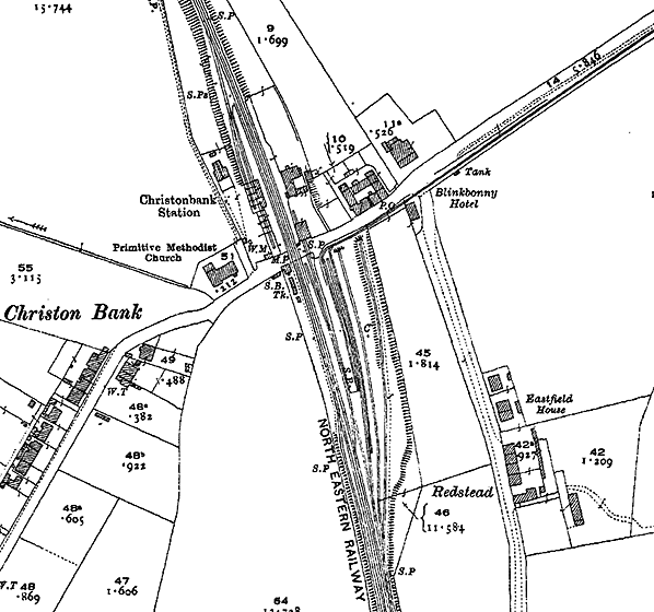
Christon Bank station was also typical of the N&B style in having two facing platforms. The station building was placed on the up platform and it is still standing. The two-storey structure is built of sandstone ashlar. Its projecting wings have kneelers, and raised gables topped with ball finials; the south wing has a canted a bay window on the ground floor, facing the platform. The larger window openings were designed with mullions (although these features have been removed) and the two upper-storey openings between the wings at the centre of the platform frontage, and on the other elevations, were also given small gables and finials. Two sets of quadruple chimneystacks soar above the central section of the building. A platform verandah, long removed, was clasped between the wings and supported at the front by pillars.
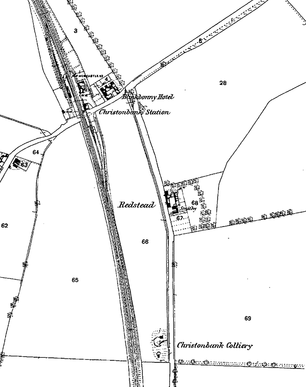
 Between the station building and the level crossing is the goods shed, or warehouse, now converted for residential use. It is a fitting neighbour to the station building, constructed of the same materials, and having a pitched roof, kneelers, raised gables and ball finials. Between the station building and the level crossing is the goods shed, or warehouse, now converted for residential use. It is a fitting neighbour to the station building, constructed of the same materials, and having a pitched roof, kneelers, raised gables and ball finials.
The down platform had an altogether more modest building: it was the typical N&B waiting shed, built of sandstone with a pent roof sloping down towards the platform edge. To complement the station building on the opposite platform, the upper ends of the shed were given ball finials. Originally open to the elements, the shed was enclosed in NER days to provide greater comfort and a fireplace and chimney were installed at its northern end.
The signal box, located on the down side immediately south of the level crossing, was operating by October 1877. It was an NER N2 design with a stone base. In 1890 its Stevens frame had 24 levers. In 1912 the box was extended to accommodate 35 levers.
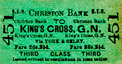
In April 1849 Reid’s first Monthly Time Table shows three train departures to Newcastle, at 8.07 and 11.37am and 6.21pm on weekdays, with Sunday departures at 7.54am and 6.10pm. Trains for Berwick left at 8.49am and at 3.26, 5.36 and 8.41pm, with Sunday departures at 9.04am and 8.01pm. At that time the limited stop services between Newcastle and Berwick usually called at Morpeth, Acklington, Lesbury (for Alnwick) and Belford, with some also serving Tweedmouth. Bradshaw of February 1863 shows a reduced service with three weekday departures in each direction and only one each way on Sunday.
By the late 1860s the small settlement close to Christon Bank station amounted to a dozen-or-so cottages, the Rising Sun Inn, and the Blinkbonny Hotel immediately east of the station. Whilst some of the more isolated stations on the ECML never attracted housing and associated services, by 1897 Christon Bank had gained a Primitive Methodist chapel, just west of the station, and a pair of semidetached cottages for railway staff behind the down platform.
The 1867 OS map shows two sidings behind the northern end of the down platform (serving the coal depot) but the principal goods facilities were on the up side. The goods warehouse, adjacent to the up passenger platform and thus north of the level crossing, was entered by a siding from the south over the crossing; the goods dock, however, was located south of the crossing.
Christonbank Colliery, a quarry and lime works are shown on the 1867 OS map several hundred yards south of the station. Situated a very short distance east of the railway the colliery in particular would seem admirably placed to have been rail-served, but the map gives no evidence that it was. Research by Jermy (2011) has yielded nothing conclusive on any link with the main line or of a tramway that local residents suggest might have existed in connection with these former industrial sites.
 Whilst the nearby colliery, quarry and lime works might not have contributed rail-borne traffic to Christon Bank station, it was to become one of the many wayside stations on the ECML in Northumberland to be associated with mines or quarries. The resistant igneous rock known as whinstone outcrops at various places in Northumberland and is valuable for road surfacing and as building stone, and by 1850 quarrying of this material was established at Embleton. Jermy (2011) provides a wealth of information on many aspects of the quarry’s history and its importance to Christon Bank station. The output of Embleton Quarry was carted by road to Christon Bank station or to the small harbour at Craster to be sent further afield, but in 1895 a contract was offered for a tramway or wagonway to be constructed between the quarry, immediately north of Embleton village, and Christon Bank station. The tramway was a little less than 1½ miles in length and 2ft 9in gauge, and for most of its length it accompanied public roads, in the manner of some of the Irish narrow gauge lines. Its course can be seen on the accompanying one-inch OS map. Horse traction was used at first, but the first steam locomotive was acquired in 1904, and another in 1909. A plan of 1909 indicates that by that date at Christon Bank the tramway approached via a crossing over the Alnwick road, then split into two after entering the NER’s property. The first line consisted of a siding parallel to, and to the west of, two NER sidings; the second passed onto a loading dock with one NER siding to the east and another siding (leading to the goods shed) to the west. There was a run-round loop on the loading dock allowing the incoming loco to run around its train, attach itself to the other end and position the wagons where needed for unloading. In 1913 there were 31,375 tons of roadstone and 2,407 tons of building stone from the quarry dispatched from Christon Bank station. In addition to this mineral traffic, in the same year 202 tons of hay/clover and 276 vans of livestock were loaded at the station. Whilst the nearby colliery, quarry and lime works might not have contributed rail-borne traffic to Christon Bank station, it was to become one of the many wayside stations on the ECML in Northumberland to be associated with mines or quarries. The resistant igneous rock known as whinstone outcrops at various places in Northumberland and is valuable for road surfacing and as building stone, and by 1850 quarrying of this material was established at Embleton. Jermy (2011) provides a wealth of information on many aspects of the quarry’s history and its importance to Christon Bank station. The output of Embleton Quarry was carted by road to Christon Bank station or to the small harbour at Craster to be sent further afield, but in 1895 a contract was offered for a tramway or wagonway to be constructed between the quarry, immediately north of Embleton village, and Christon Bank station. The tramway was a little less than 1½ miles in length and 2ft 9in gauge, and for most of its length it accompanied public roads, in the manner of some of the Irish narrow gauge lines. Its course can be seen on the accompanying one-inch OS map. Horse traction was used at first, but the first steam locomotive was acquired in 1904, and another in 1909. A plan of 1909 indicates that by that date at Christon Bank the tramway approached via a crossing over the Alnwick road, then split into two after entering the NER’s property. The first line consisted of a siding parallel to, and to the west of, two NER sidings; the second passed onto a loading dock with one NER siding to the east and another siding (leading to the goods shed) to the west. There was a run-round loop on the loading dock allowing the incoming loco to run around its train, attach itself to the other end and position the wagons where needed for unloading. In 1913 there were 31,375 tons of roadstone and 2,407 tons of building stone from the quarry dispatched from Christon Bank station. In addition to this mineral traffic, in the same year 202 tons of hay/clover and 276 vans of livestock were loaded at the station.
The Railway Clearing House Handbook of stations (1904) reported that Christon Bank had a full range of goods facilities, possessed a 5-ton capacity yard crane, and supervised the siding at Fallodon, the Grey family’s private station about a mile to the north: Christon Bank’s stationmaster also had charge of Fallodon. The layout of Christon Bank station in 1912 is shown in the accompanying plan. Click here for a larger version.

In common with most of the wayside stations on the East Coast main line in northern Northumberland the amount of passenger traffic at Christon Bank was modest, with 8,185 tickets sold in 1911. The population served by the station that year was reckoned to be 1,002.
The winter 1912-13 NER timetable shows the following service:
Up trains: weekdays |
Destination |
Down trains: weekdays |
Destination |
7.36am |
Alnwick |
10.02am |
Beal |
8.22am |
Alnwick |
12.35pm |
Berwick |
10.06am |
Alnwick |
1.36pm (Sat only) |
Berwick |
12.09am (Sat only) |
Alnwick |
3.36pm |
Berwick |
2.29pm |
Alnmouth |
5.18pm (Sat only) |
Berwick |
3.16pm (Sat only) |
Alnmouth |
7.03pm |
Lucker |
4.25pm (Sat only) |
Alnmouth |
9.05pm |
Berwick |
6.13pm |
Alnmouth |
- |
- |
Up trains: Sunday |
Destination |
Down trains: Sunday |
Destination |
7.11am |
Newcastle |
9.54am |
Berwick |
6.44pm |
Newcastle |
8.28pm |
Berwick |
The first northbound departure of the day is shown to run as far as Beal; this train waited at Beal for about half-an-hour, moving off the main line to enable a northbound express to call, before completing its journey to Berwick. Passengers on the 10.02am ex-Christon Bank could change at Belford or Beal to catch this faster train to Berwick or onward to Edinburgh.
In 1923 at the ‘Grouping’ the NER was absorbed into the new London & North Eastern Railway. The LNER seems to have made few changes at Christon Bank station, but it did install running-in nameboards with metal letters pinned to a wooden board. During LNER years Embleton Quarry reduced its dependence on the narrow gauge tramway to dispatch its stone. Before 1920 the enterprising owner possessed a couple of steam lorries to make deliveries of stone in the local area, but in the 1930s four petrol lorries were purchased, again for local deliveries. The tramway had fallen out of use by 1941; it is still shown on the OS one-inch map published in 1947. Passenger business at Christon Bank declined in the 1920s and ‘30s as bus services were provided through Embleton village. In summer 1931 Messrs Rutherford operated services between Alnwick, Embleton, Bamburgh and Berwick and Bolton Bros’ buses passed through the village on the route between Newcastle, Alnwick and Bamburgh. It is not apparent that any buses served Christon Bank at that time.
The LNER winter 1937-38 timetable:
Up trains: weekdays |
Destination |
Down trains: weekdays |
Destination |
8.16am |
Alnwick |
8.03am |
Kelso |
9.24am |
Newcastle |
10.07am |
Beal |
2.19pm |
Newcastle |
1.32pm |
Berwick |
4.24pm |
Alnmouth |
2.48pm |
Berwick |
5.32pm |
Alnmouth |
5.34pm |
Berwick |
- |
- |
7.55pm |
Berwick |
Up trains: Sunday |
Destination |
Down trains: Sunday |
Destination |
7.06am |
Newcastle |
9.45am |
Berwick |
6.24pm |
Newcastle |
8.09pm |
Berwick |
 The morning train advertised as terminating at Beal was a durable feature of the timetable having been seen in the 1912-13 departures. The 5.11pm departure was shown in the public timetable to start at Christon Bank; however it is the same train that arrived from Alnmouth at 5.17pm and which had a rest-over at Christon Bank while an express overtook it, which involved moving the train off the main line. The timetable showed this train to be one class only, so it was presumably a steam railcar or a push-and-pull, which would have made the manoeuvres at Christon Bank straightforward. The morning train advertised as terminating at Beal was a durable feature of the timetable having been seen in the 1912-13 departures. The 5.11pm departure was shown in the public timetable to start at Christon Bank; however it is the same train that arrived from Alnmouth at 5.17pm and which had a rest-over at Christon Bank while an express overtook it, which involved moving the train off the main line. The timetable showed this train to be one class only, so it was presumably a steam railcar or a push-and-pull, which would have made the manoeuvres at Christon Bank straightforward.
Six of the main line stations between Alnmouth and Berwick handled so little passenger traffic that they were closed as a wartime economy on 5 May 1941 – Christon Bank was one of these. The LNER reopened them on 7 October 1946, probably responding to local pressure. It is thought that trains never called at Christon Bank on Sundays when the station reopened after the war. Significantly, each of these stations which closed during the war had closed again before the ‘Beeching Report’ was published in 1963.
From 1 January 1948 on nationalisation the ECML in Northumberland became part of British Railways’ North Eastern Region. Under the new regime there was no significant investment in Christon Bank station. Regional identity was shown by repainting the nameboards tangerine. The station continued, as it had from its opening, to be lit by oil lanterns. By summer 1950 train departures were few:
Up trains: weekdays |
Destination |
Down trains: weekdays |
Destination |
8.10am |
Newcastle |
9.18am |
Berwick |
9.52am (Saturday only) |
Newcastle |
5.29pm (Mon-Fri) |
Edinburgh |
5.45pm |
Newcastle |
5.37pm (Saturday only) |
Edinburgh |
- |
- |
7.08pm (Mon-Fri) |
Berwick |
- |
- |
7.11pm (Saturday only) |
Berwick |
No Sunday departures |
- |
No Sunday departures |
- |
In its later years this rural station was little used, booking only 440 tickets in 1951. In the final timetable of summer 1958 there were only two departures in each direction on weekdays from Christon Bank. The station closed to passengers together with nine others between Newcastle and Berwick on 15 September 1958, but goods traffic continued to be dealt with. Embleton Quarry, which had been such an important source of mineral traffic for Christon Bank station, ceased production in 1962/63, and the station closed entirely on 7 June 1965.
 A new frame of 26 levers was installed in the signal box in July 1959. The level crossing gates were replaced with barriers on 21 October 1973, and the signal box closed on 8 September 1974. Thereafter the crossing was supervised from Chathill by CCTV, but when this box closed in December 1990 supervision was transferred to Alnmouth. The base of the Christon Bank box has been retained as a relay room. A new frame of 26 levers was installed in the signal box in July 1959. The level crossing gates were replaced with barriers on 21 October 1973, and the signal box closed on 8 September 1974. Thereafter the crossing was supervised from Chathill by CCTV, but when this box closed in December 1990 supervision was transferred to Alnmouth. The base of the Christon Bank box has been retained as a relay room.
The platforms and the down side waiting shed were demolished by the late 1960s, but both the station building and the goods warehouse have been renovated for residential use. Ironically, without a station to serve them, small housing estates have been built either side of the railway south of the level crossing. One of the estates is on the site of the goods yard, and appropriately one of its roads is known as ‘The Sidings’. The route of the narrow gauge tramway from Embleton Quarry to Christon Bank station can still be identified on the ground, and a broad grass verge by the road just east of Christon Bank marks its course.
Click here for a brief history of the East Coast Main Line
in Northumberland.
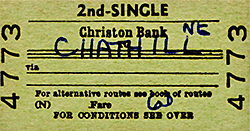
Route maps drawn by Alan Young. Tickets from Michael Stewart.
BIBLIOGRAPHY:
- Addyman, John F (Editor) A history of the Newcastle & Berwick Railway (North Eastern Railway Association, 2011) – especially Chapter 5 ‘The buildings’ by Bill Fawcett
- Biddle, Gordon Victorian stations (David & Charles, 1973)
- Fawcett, Bill A history of North Eastern Railway architecture Vol 1: The Pioneers (North Eastern Railway Association 2001)
- Fleming, John M Little Mill station – and a royal visitor in North Eastern Express No.96 (NERA August 1984)
- Young, Alan Railways in Northumberland (Martin Bairstow, 2003)
- Quick, Michael Railway passenger stations in Great Britain: a chronology (RCTS 2009)
- Clinker, C R Clinker’s register of closed passenger stations and goods depots (Avon Anglia 1978)
- Jermy, Roger Northern Northumberland’s minor railways Vol 3: Sandstone, whinstone & gravel lines (Oakwood Press 2011)
- Hoole, K Railway stations of the North East (David & Charles 1985)
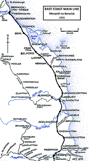
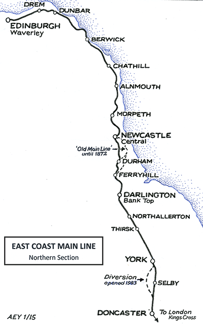
See other ECML stations:Tweedmouth, Scremerston, Goswick, Beal, Smeafield, Crag Mill, Belford, Lucker,
Newham, Fallodon, Little Mill,
Longhoughton, Lesbury, Warkworth, Longhirst, Ashington Colliery Junction, Morpeth, Stannington, Plessey, Annitsford (1st), Annitsford (2nd), Killingworth, Forest Hall, Heaton (2nd), Heaton (1st), Durham, Croft Spa, Eryholme, Otterington, Alne & Tollerton |

bank_old1.jpg)
bank_old2.jpg)
old3.jpg)
bank1.jpg)
bank2.jpg)
bank4.jpg)

 Home Page