
Station Name: CRAG MILL[Source: Alan Young]
mill1.jpg) Crag Mill crossing keeper’s cottage and timber cabin looking north-east over the level crossing in 1966. The cottage is brick-built, whilst others on the Newcastle & Berwick Railway were of stone and its design bears only a weak resemblance to them. The passenger station here was to the north-west of the crossing – that is to say, to the left of the picture - and it appears to have been in use by 1857 and closed in 1877. The cottage was possibly pressed into service as accommodation for station staff during this period.
Photo by John M Fleming / NERA 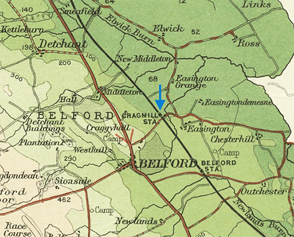 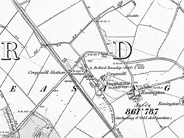
1865 1: 10,560 OS map. Cragmill [sic] station is named, but no platforms are shown. The positioning of the name suggests that the passenger station was north-west of the level crossing and that it therefore adjoined the crossing keeper’s cottage. A coal depot is indicated south-east of the level crossing. There are a few isolated buildings and hamlets in the vicinity of the station which must have justified its opening but, it seems, insufficient population to make it worth providing a daily train service when it briefly appeared in the public timetable in the mid 1870s.
1865 1: 2,500 OS map. The source of this map of Cragmill is the same survey as was used on the 1: 10,560 map. The larger scale permits the two main line railway tracks to be shown as well as two sidings into the coal depot, south-east of the crossing on the up side of the main line. The station name on this map is shown south-east of the level crossing. An early twentieth century ‘half inch’ Bartholomew’s map indicates that the passenger station was north-west of the level crossing'
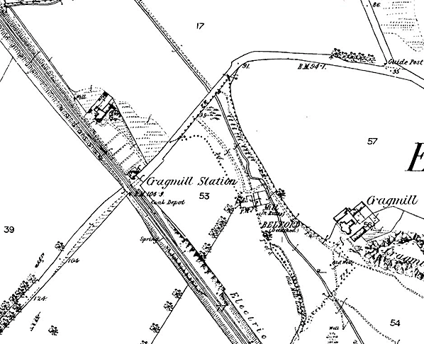
 1898 1: 2,500 OS map. Cragmill [sic] ceased to be a passenger station in 1877, and it is now referred to as Cragmill Siding. The signal box immediately south-east of the level crossing, on the down side, has been added. There appears to be an outline of a platform adjoining one of the sidings
in the coal depot. 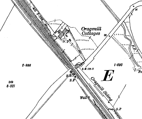
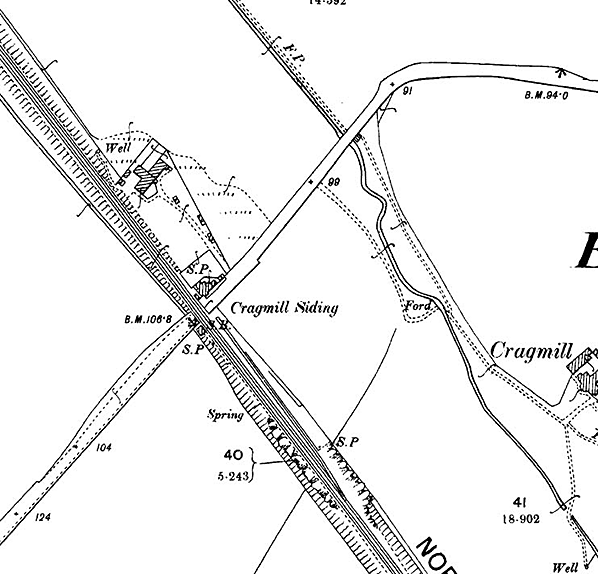
1924 1: 2,500 OS map. Only one siding is now shown as entering the coal depot. In other respects there has been little change in the locality of Cragmill within the area of this map. At about this time Cragmill Quarry opened beyond the western border of the map. Although it had internal narrow gauge railways there was never a rail connection to the main line.
mill2.jpg)
Crag Mill signal box is seen in this 1960s view, looking west. The box was constructed by October 1877 and was a brick-built North Eastern Railway N2 design. In 1962 it was reduced to gate box status, closed in 1977 and subsequently demolished.
mill3.jpg)
Looking north-west from the level crossing at Crag Mill in August 1986.
There is no trace of any passenger platforms of the station which closed in 1877. The former crossing keeper's cottage is off the picture, to the right. Photo by John Mann mill4.jpg) Looking south-east from the level crossing at Crag Mill in August 1986. The structure on the left is part of the coal depot which long outlived the passenger facility here.
Photo by John Mann mill5.jpg)
Looking south-west towards the level crossing at Crag Mill in May 2015. The former crossing keeper's cottage is on the right. The passenger station was to the north-west of the crossing – behind the building - and it appears to have been in use by 1857 and closed in 1877. The cottage was possibly pressed into service as accommodation for station staff during this period.
Photo
by Roger Cornfoot, reproduced from Geograph under creative commons licence
mill6.jpg)
Looking north at Crag Mill on 30 July 2015. The crossing keeper’s cottage is beyond the level crossing. Virgin East Coast 82 206 is working the 1E 19 14:30 Edinburgh – London Kings Cross service and passing the site of the short-lived passenger station.
Photo by Terry Callaghan mill8.jpg)
The site of Crag Mill station looking north-west from the level crossing in July 2015. The building on the right is the crossing keeper’s cottage, which possibly served as the station house for the short time that the station was open
Photo by Terry Callaghan mill9.jpg) Looking south-east from the level crossing at Crag Mill in July 2015. The crossing cottage and former passenger station are behind the photographer. The structure on the left is part of the coal depot which long outlived the passenger facility here.
Photo by Terry Callaghan mill10.jpg)
The crossing keeper’s cottage at Crag Mill, looking north-west in July 2015. Although built of brick (whilst other such cottages on the ECML in Northumberland were of stone) there is a stone section to the right of the main building. It was not one of the structures provided when the line was opened by the Newcastle & Berwick Railway in 1847, but was probably constructed in the mid-to-late 1850s.
Photo
by Terry Callaghan
mill7.jpg)
Fragments of brick masonry, immediately south-east of Crag Mill level crossing, are all that remain of the signal box in July 2015.
Photo
by Terry Callaghan
|
 This unfortunate station has from suffered from inaccurate descriptions in several publications. In R V J Butt’s The directory of railway stations (1995) the author wrongly states that this station and other late openers such as Goswick and Forest Hall on the ECML in Northumberland opened with the line in 1847. Two atlases have catapulted the station from Northumberland into Yorkshire. C J Wignall’s Complete British Railways maps and gazetteer (First edition, 1983) incomprehensibly places the station (as Cragg Mill) between Horsforth and the southern portal of Bramhope Tunnel. This error is repeated in Tony Dewick’s useful publication Complete atlas of railway station names (2002). The present writer also has to hang his head in shame as in Railways in Northumberland (2003) the photograph captioned as Cragg Mill is, in fact, the roadside elevation of Scremerston station, further north on the ECML. Robert Kinghorn in Lost railways of Northumberland (2006) has regrettably been misled by this error. The source of the misinformation about the building is a wrongly labelled photograph in an album housed in the Ken Hoole Study Centre, North Road station, Darlington.
 Smeafield, the next station to the north, also appeared in the working timetable of February 1871. Both stations had restricted services. In Bradshaw of May 1877 Crag Mill is served ‘when required’ by the 8.05am, 1.20pm and 6.15pm departures from Newcastle on Tuesday and Saturday only and on the same days, again ‘when required’, by the 6.30am and 5.20pm trains from Berwick. Tuesday was market day in Belford, and Berwick and Alnwick markets were held on Saturday.
 Home Page