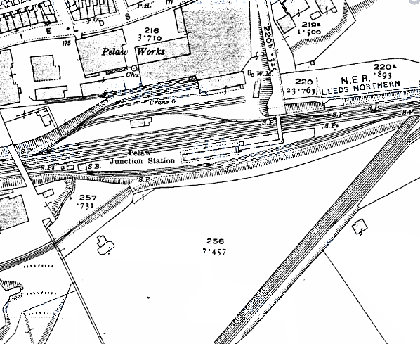
Notes: In 1894 the NER began quadrupling the line between Gateshead and Pelaw, and in the process both Felling and Pelaw received new island platform stations served only by the southern (‘slow’) pair of tracks. Although the two stations were designed at the same time, their buildings were entirely different. Fawcett (2005) notes that whereas Felling was a modern-looking station with a broad, glazed platform roof. Pelaw looked like another company’s design, picked up by mistake. It consisted of a low brick building with a flat awning cantilevered out on wooden beams and finishing up with a rather ugly deep valance with shallow crenellations. At the west end the awning was supported by a lengthy screen with enormous windows, and the valance with its crenellations was continued along it. An enclosed ramp led down to the platform from the east, and it disappeared into a boxy wooden structure attached to the station building which, like the west end screen, was embellished with a continuation of the valance crenellations, and wind screens were attached. A standard stationmaster’s house was provided on the approach to the station.
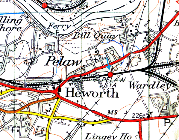
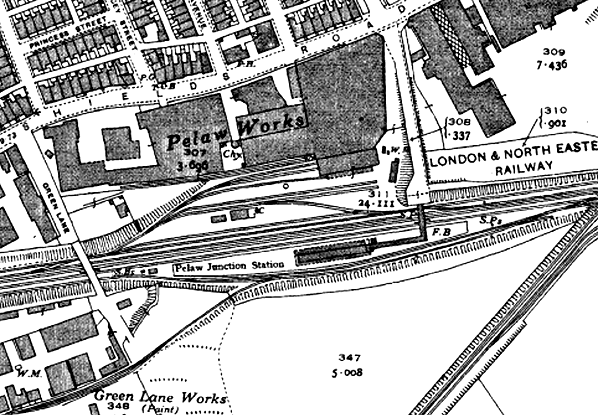
Until the end of the nineteenth century Pelaw station stood in semi-rural surroundings, with the small settlements of Wardley, Bill Quay and Heworth approximately equidistant from it. However the development of a complex of Co-operative Wholesale Society (CWS) factories close to the station provided much local employment and was a reason for the spread of residential terraces and some semidetached housing across the fields to the north of the station. These factories were prominent local landmarks and stretched for about a mile along Shields Road, north of the station, with associated sidings. They manufactured a wide range of products including quilts, books and magazines, furniture, clothing and textiles, pharmaceuticals and household cleaning materials. The most famous product, at one time of world renown, was ‘Pelaw Polish’, for cleaning shoes. The CWS factories were closed and demolished between the mid 1970s and early 1990s as a result of overseas competition.
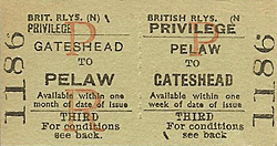
In 1911 the NER recorded that Pelaw served a population of 25.026 and 207, 536 tickets were issued.
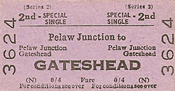
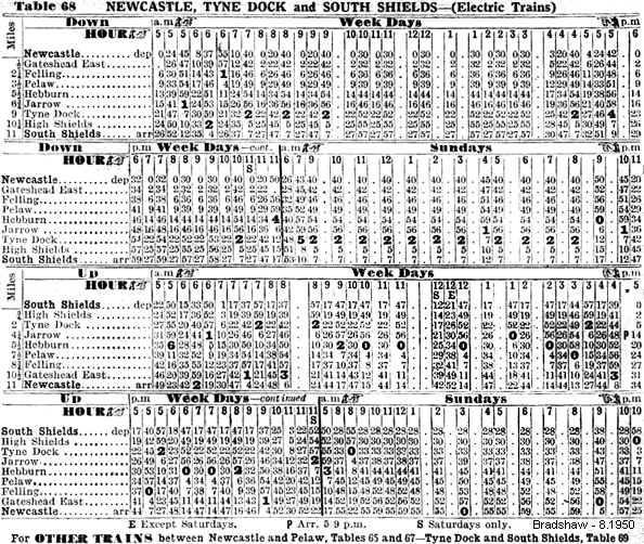
 In 1923 at the Grouping of Britain’s railways the NER lines, and thus Pelaw station, were allocated to the London & North Eastern Railway. At Nationalisation in January 1948 the former LNER lines and stations in north-east England were placed within the North Eastern Region of British Railways. Throughout the twentieth century Pelaw enjoyed a frequent service of trains on the Newcastle to Sunderland and South Shields routes, and some calls by trains on the Washington route until they were all but extinguished in the late 1940s. From March 1938 until January 1963, when they gave way to DMUs, the South Shields service was operated by electric multiple units. DMUs had replaced the steam-hauled Newcastle - Sunderland local trains in August 1958 In 1923 at the Grouping of Britain’s railways the NER lines, and thus Pelaw station, were allocated to the London & North Eastern Railway. At Nationalisation in January 1948 the former LNER lines and stations in north-east England were placed within the North Eastern Region of British Railways. Throughout the twentieth century Pelaw enjoyed a frequent service of trains on the Newcastle to Sunderland and South Shields routes, and some calls by trains on the Washington route until they were all but extinguished in the late 1940s. From March 1938 until January 1963, when they gave way to DMUs, the South Shields service was operated by electric multiple units. DMUs had replaced the steam-hauled Newcastle - Sunderland local trains in August 1958
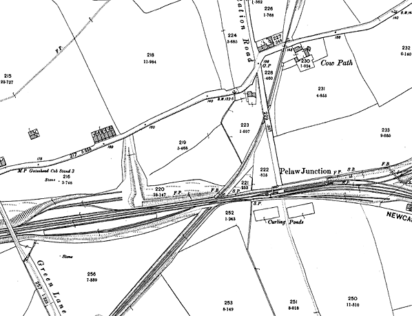
In BR ownership in the late 1950s the station was fitted with vitreous enamel running-in boards and totem name signs with black-edged lettering. In about 1961 electric lighting replaced gas, using concrete standards with small, plain lampshades of a style frequently found at that time on streets but rarely in stations; East Boldon, Malton and Garforth were among other stations favoured with such lamps. Neighbouring Felling station retained gas lighting. In October 1960 a signal box of modern design was opened adjacent to Pelaw Junction.
The Reshaping of British Railways (‘Beeching’) report of March 1963 did not recommend the Newcastle – Sunderland / South Shields local services and stations for closure, but the Washington route was earmarked. The closure to passengers of the line to Washington on 9 September 1963 entailed the withdrawal of the Newcastle to Washington train departing from Pelaw at 8.44 am and a reverse working from Washington to Newcastle which called at 5.47 pm, both operating on Monday-to-Friday only. As part of the programme of withdrawing goods services from wayside stations, Pelaw ceased to handle this traffic on 4 October 1965. On 2 January 1967 the North Eastern Region was abolished and its lines and stations were transferred to Eastern Region management. The Newcastle – Sunderland and South Shields branch local services were among those changed by the Eastern Region to ‘Paytrain’ operation in which, as an economy measure, booking offices were closed at all but the most important stations and tickets were issued instead by conductor-guards on the train. Pelaw and all of the other intermediate stations between Newcastle and Sunderland / South Shields consequently became unstaffed on 5 October 1969. Without staff in place, Pelaw station buildings were targeted by vandals. In early 1972 BR demolished all of the buildings, replacing them with a brick shelter. Electric lighting on the tall vandal-proof standards favoured by the Newcastle Division of the Eastern Region was installed. In 1974/5 Corporate Identity name signs were added.
Plans were approved in 1973 for conversion of the South Shields branch to light rail operation as part of the Tyne & Wear Metro. In preparation for this Felling and Pelaw stations were to close and be replaced with a new station at Heworth approximately midway between the two to act as an interchange between Sunderland line trains (which would continue to be operated by British Rail) and the South Shields Metro services. Heworth opened and Felling and Pelaw closed on 5 November 1979. Pelaw station was demolished. However Felling was rebuilt and reopened on 15 November 1981 to be served by the frequent South Shields Metro trains, but not the Sunderland trains.
BRIEF HISTORY OF 'THE OLD MAIN LINE'
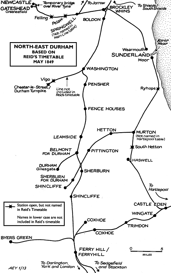
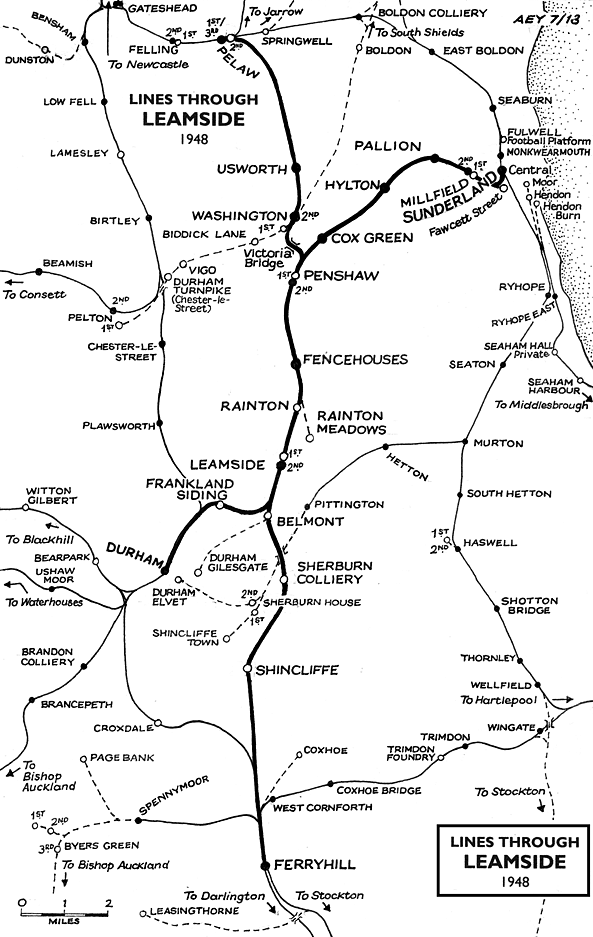
The ‘Old Main Line’ was the name frequently given to the railway between Ferryhill and Pelaw in County Durham which, from 1850 until 1872 formed part of the ‘East Coast’ route from London (Kings Cross) to Newcastle. Prior to 1850 trains ran via Brockley Whins, prior to the opening of the Washington – Pelaw line, and until 1848 terminated at Gateshead rather than Newcastle. From 1872 the present East Coast main line route was used, with diversions in 1906 when the opening of King Edward Bridge removed the need to travel via Gateshead (West) and at Newton Hall Junction, north of Durham, where the curvature of the tracks was reduced in the late 1960s. The evolution of the ‘Old Main Line’ was far from straightforward.
By the beginning of the nineteenth century waggonways were already in existence to move coal from the mines in south-east Northumberland and north-eastern County Durham to tidal water for export. It stands to reason that passengers will have been carried unofficially on such lines, but the first recorded passenger transport by rail in north-east Durham was in 1834 on the Pontop & South Shields route. Originally opened as the Stanhope & Tyne Railroad, it was not established by parliamentary Act but was built on the ‘wayleave’ system under a Deed of Settlement dated 3 February 1834, perhaps to conceal the ambitious nature of the scheme, which was 33¾ miles in length. Under this arrangement the company was to pay a toll, based on the amount of traffic carried, to each landowner through whose property the railway passed.
The south-western end of the line was in Weardale, on the moors just south of Stanhope. Here limestone was quarried, and there were deposits of coal available at intervals between Consett and South Shields. In July 1832 building of the line began, and progress was rapid. Although much of the terrain it crossed was moorland at high altitude, few earthworks were constructed or excavated, and some steep slopes on the south-western section of the route were negotiated with inclines; indeed more than half was worked by inclined planes, either self-acting or with a winding engine, and a few near-level stretches were worked by horses. Locomotives were used only at the eastern end. Much of the line remained unfenced until it closed in the 1960s. The route from Stanhope lime-kilns to Annfield was opened on 15 May 1834, and the eastern section onward to South Shields on 10 September 1834. The engineer T E Harrison surveyed the route; he was to become one of the most influential personnel of the NER.
The carriage of minerals was the priority of the Stanhope & Tyne, and no attempt was made to serve centres of population which would generate passenger traffic. Nevertheless there were requests for passengers to be conveyed so they were permitted to ride free-of-charge on top of the coal wagons. Soon a wagon was attached specifically for passenger use, and shortly afterwards a separate locomotive-hauled passenger coach was provided fortnightly on pay days. Finally, on 16 April 1835, a full passenger service was instated between Durham Turnpike (one mile north of Chester-le-Street) and South Shields, possibly calling from the start at Vigo and Washington. At South Shields a nearby inn sold tickets, and passengers boarded the train in sidings. Part of this route, from Washington to Brockley Whins, was to become a section of the original ‘Old Main Line’. The isolated stretch of passenger railway between Durham Turnpike and South Shields was joined by the Brandling Junction Railway from Gateshead to Brockley Whins, three miles south-west of South Shields, opening to minerals on 30 August 1838 and passengers on 5 September 1839; and the Durham Junction Railway, stretching north from an obscure terminus at Rainton Meadow (with horse-bus connection to Durham) to Washington opened for mineral traffic on 24 August 1838 and passengers on 9 March 1840.
Unfortunately the cost of running the Stanhope & Tyne proved unsustainable. In the moorlands wayleaves cost about £25 per mile per year, but at the eastern end the figures were £300 or more. The outgoings on wayleaves alone amounted to £5,600. Plans for a dock (where Tyne Dock was later opened) were abandoned. Traffic did not develop to the expected levels and the wayleaves proved to be financially crippling. By the close of 1840 the railway company was £440,000 in debt, and it was wound up on 5 February 1841. The following year the Pontop & South Shields Railway obtained an Act to take over the northern end of its track which had hosted the passenger service. The Derwent Iron Company took control of the section south-west of Carr House to bring limestone from Stanhope to its furnaces at Consett. This section later passed into the hands of the S&D.
 The Brandling Junction Railway (BJ) originated as a private venture by brothers R W and J Brandling to connect Gateshead, South Shields and Monkwearmouth. The brothers obtained an Act to buy or purchase leases for the land over which their lines would pass, but they chose to proceed by the wayleave system. A company came into being on 7 September 1835 to acquire the assets of the Brandling Railway, and as the Brandling Junction Railway Company it was incorporated by Act of Parliament on 7 June 1836. The Stanhope & Tyne also sponsored a Gateshead, South Shields & Monkwearmouth Railway, but discussions with the BJR resulted in the abandonment of the plan. The BJR opened in three sections. The first was from the Newcastle & Carlisle Railway’s Redheugh in Gateshead, adjacent to the River Tyne, which ascended at 1:23 through Greenes Field to Oakwellgate; this was operated by a stationary engine. A self-acting incline from Gateshead Quayside was opened with it on the same day, 15 January 1839. The route from South Shields to Monkwearmouth opened on 19 June 1839, followed by the connecting lines between Gateshead and Cleadon Lane (later East Boldon) and between Brockley Whins and Green Lane (north-east of Brockley Whins) on 5 September 1839. A chord known as the Newton Garths branch opened on 9 September 1839 between East Boldon and West Boldon junctions, immediately south-east of Pontop Crossing, but this was not used by passenger trains. On 9 March 1840 the west-to-north link between the BJ and S&T opened at Pontop Crossing which enabled through services between the several termini at Gateshead, South Shields, Monkwearmouth and the Durham Junction Railway’s Rainton Meadows to operate. However services from the south had, at first, to reverse from just north of Pontop Crossing to reach Brockley Whins in a complex operation (described on the Brockley Whins page). The Brandling Junction Railway (BJ) originated as a private venture by brothers R W and J Brandling to connect Gateshead, South Shields and Monkwearmouth. The brothers obtained an Act to buy or purchase leases for the land over which their lines would pass, but they chose to proceed by the wayleave system. A company came into being on 7 September 1835 to acquire the assets of the Brandling Railway, and as the Brandling Junction Railway Company it was incorporated by Act of Parliament on 7 June 1836. The Stanhope & Tyne also sponsored a Gateshead, South Shields & Monkwearmouth Railway, but discussions with the BJR resulted in the abandonment of the plan. The BJR opened in three sections. The first was from the Newcastle & Carlisle Railway’s Redheugh in Gateshead, adjacent to the River Tyne, which ascended at 1:23 through Greenes Field to Oakwellgate; this was operated by a stationary engine. A self-acting incline from Gateshead Quayside was opened with it on the same day, 15 January 1839. The route from South Shields to Monkwearmouth opened on 19 June 1839, followed by the connecting lines between Gateshead and Cleadon Lane (later East Boldon) and between Brockley Whins and Green Lane (north-east of Brockley Whins) on 5 September 1839. A chord known as the Newton Garths branch opened on 9 September 1839 between East Boldon and West Boldon junctions, immediately south-east of Pontop Crossing, but this was not used by passenger trains. On 9 March 1840 the west-to-north link between the BJ and S&T opened at Pontop Crossing which enabled through services between the several termini at Gateshead, South Shields, Monkwearmouth and the Durham Junction Railway’s Rainton Meadows to operate. However services from the south had, at first, to reverse from just north of Pontop Crossing to reach Brockley Whins in a complex operation (described on the Brockley Whins page).
The Durham Junction Railway (DJ) was authorised by an Act of 16 June 1834. It became an important link in the chain of railways forming the ‘Old Main Line’, the original intention was merely to redirect to the Tyne coal from the pits in the Houghton-le-Spring area, and from pits served by the Hartlepool Railway. Even these modest ambitions were not realised as its southern terminus was to be at Rainton Meadows, two miles short of Moorsley, its intended destination, and the Houghton-le-Spring branch, authorised by an Act of 1837, was never constructed. Nevertheless a ‘Station Road’ was partly constructed in Houghton – the triumph of hope over reality – which was to be one of the largest population centres in the North-East never to have the benefit of a passenger station.
 The DJ’s crowning glory was the stately stone viaduct over the River Wear between Penshaw and Washington, and based upon the Roman bridge at Alcántara, Spain. The last stone was laid on the day of Queen Victoria’s coronation, 28 June 1838, thus it was named Victoria Bridge (or Viaduct). The engineer T E Harrison constructed four main arches, those at each end of 100ft span and the two central arches of 160ft and 144ft; the total length was 811ft and the height above water level was 135ft. In 1843 the DJ became part of the portfolio of the ambitious George Hudson (the ‘Railway King’) as part of his plan for an integrated east-coast route. The Act of 23 May 1844 which confirmed his purchase of the line also made provision for the project of bridging the Tyne. The DJ’s crowning glory was the stately stone viaduct over the River Wear between Penshaw and Washington, and based upon the Roman bridge at Alcántara, Spain. The last stone was laid on the day of Queen Victoria’s coronation, 28 June 1838, thus it was named Victoria Bridge (or Viaduct). The engineer T E Harrison constructed four main arches, those at each end of 100ft span and the two central arches of 160ft and 144ft; the total length was 811ft and the height above water level was 135ft. In 1843 the DJ became part of the portfolio of the ambitious George Hudson (the ‘Railway King’) as part of his plan for an integrated east-coast route. The Act of 23 May 1844 which confirmed his purchase of the line also made provision for the project of bridging the Tyne.
At Washington the DJ connected with the Stanhope & Tyne whose metals were used as far as Brockley Whins. Here the BJ line was joined, and the passenger service between Rainton Meadows and Gateshead took this route from its inception on 9 March 1840. The S&T owned over half of the DJ shares and also worked the services. As noted above a reversal was necessary at Brockley Whins, and this inconvenience was compounded by congestion caused by the DJ and S&T/P&SS trains sharing the line between Washington and Brockley Whins. To allow more efficient operation powers were sought to construct a direct curve and to widen the line between Washington and Brockley Whins: an Act of 23 May 1844 authorised these projects. The curve was on a difficult site intersected by the River Don and was constructed on a wooden viaduct which stood until 1940. The viaduct was used by main line trains until 1 October 1850 when the more direct route between Washington and Pelaw via Usworth was opened.
For the next stage in the evolution of the ‘Old Main Line’ through County Durham it is necessary to return to the 1830s. The Great North of England Railway obtained its Act for a route from Redheugh Quay at Gateshead to Croft (south of Darlington) on 4 July 1836. After opening from York to Darlington the GNE decided, for financial reasons, not to construct the route onward to Gateshead, and on 5 October 1841 agreed to relinquish the powers to Robert Davies, James Richardson and John Hotham, who acted on behalf of the embryo Newcastle & Darlington Junction Railway. The N&DJ agreed to apply for powers to finish the line and pay all costs. The N&DJ was incorporated on 18 June 1842, and on 11 April 1843 the northern part of the GNE was transferred by Act of Parliament to the N&DJ. Work proceeded swiftly, and the line opened throughout on 15 April 1844 to mineral traffic and to passengers on 19 June. The short section between Belmont Junction (where the Durham branch left the main line) to join the Durham Junction line at Rainton Crossing was the last to be completed. There was now a direct railway link from London to the Tyne: on 18 June 1844, the day before the route opened to regular passenger traffic, a special train made history when it ran from London (Euston Square) to Gateshead in 9h 21m, including stops totalling 70 minutes. At the time of opening the N&DJ did not actually own the line beyond Washington, but had a station at Gateshead, reached via the P&SS and BJ railways: although only authorised by the Act of 23 May 1844 the station was illustrated by an engraving in a Gateshead newspaper four weeks later.
The early days of the N&DJ were difficult owing to strained relations with the GNE. For details see K Hoole’s Regional History vol 4.
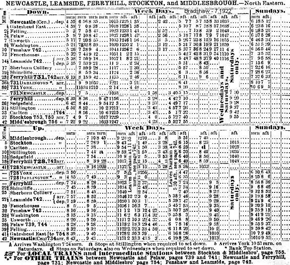
The original ‘East Coast’ main line of 1844 therefore ran from Ferryhill to Gateshead via Shincliffe, Leamside, Penshaw, Washington, Brockley Whins and Pelaw. The Gateshead terminus was at Oakwellgate, which had opened on 5 September 1839. On 2 September 1844 Oakwellgate closed, and the service was diverted to the Greenesfield terminus, which had opened on 19 June 1844. This terminus, in turn, gave way to a new through station which would eventually be known as Gateshead East, when the main line was extended to Newcastle Central, crossing the River Tyne on a temporary bridge (opened 1 November 1848) then on the High Level Bridge, which opened on 30 August 1850. From 1 October 1850 the new, shorter route via Usworth was used between Washington and Pelaw, avoiding Brockley Whins. This ‘Old Main Line’ or ‘Leamside’ route was used until 15 January 1872 when through express services were diverted to the route via Durham.
 The ‘Old Main Line’ continued life as an important freight route and retained its stopping passenger service between Leamside and Ferryhill into LNER days. This service - latterly amounting to four up and five down trains on weekdays and one up on a Sunday, calling at the intermediate stations of Shincliffe and Sherburn Colliery – was to have been withdrawn in 1939 but closure was deferred until June 1941. Thereafter the Leamside – Ferryhill line was used for passenger trains diverted from the main line via Durham and for freight traffic. In 1991 British Rail mothballed the line, but owing to dumping of rubbish on the lines, removal of rails at level-crossings, theft of 2½ miles of track near Penshaw in 2003, and effects of overall neglect Network Rail decided to close the line entirely and the rails were removed by April 2013. Concrete sleepers recovered from the route are understood to be destined for re-use on the Waverley Route currently under construction between Edinburgh, Galashiels and Tweedbank. The ‘Old Main Line’ continued life as an important freight route and retained its stopping passenger service between Leamside and Ferryhill into LNER days. This service - latterly amounting to four up and five down trains on weekdays and one up on a Sunday, calling at the intermediate stations of Shincliffe and Sherburn Colliery – was to have been withdrawn in 1939 but closure was deferred until June 1941. Thereafter the Leamside – Ferryhill line was used for passenger trains diverted from the main line via Durham and for freight traffic. In 1991 British Rail mothballed the line, but owing to dumping of rubbish on the lines, removal of rails at level-crossings, theft of 2½ miles of track near Penshaw in 2003, and effects of overall neglect Network Rail decided to close the line entirely and the rails were removed by April 2013. Concrete sleepers recovered from the route are understood to be destined for re-use on the Waverley Route currently under construction between Edinburgh, Galashiels and Tweedbank.
The Durham diversion was, like the development of the Leamside route, a result of evolution rather than one direct action.
BRIEF HISTORY OF 'THE NEW MAIN LINE'
Access to Gateshead from the south was via Leamside until 1872, when the present-day East Coast main line superseded it. However much earlier, in July 1846, the York & Newcastle Railway announced its intention to promote a Bill for a line following a route via the Team valley from Gateshead (and ultimately Newcastle). On 30 June 1848 the Y&N – by now the York, Newcastle & Berwick Railway – obtained an Act authorising construction. The proposed route was from Gateshead via Team Valley to Newton Hall, where a branch to Durham and Bishop Auckland continued southwards, while the main line curved eastwards for about a mile then turned south to join the main line near Belmont Junction. However in 1849 the work was postponed owing to the downfall of George Hudson.
 The NER in 1862 revived the project, but the line authorised was only between Gateshead and Newton Hall on the Bishop Auckland branch north of Durham, which had opened from Leamside in 1857. The section eastwards from Newton Hall had been constructed as part of the Bishop Auckland branch, but there was no west-to-south curve near Leamside to allow through running from the north onto the old main line via Shincliffe. Consequently the new line could be used only as an alternative route to Durham and the south via Bishop Auckland; and at first there were only four stopping trains in each direction between Newcastle and Durham. The Team Valley route opened on 1 December 1868, and it became part of the ‘new’ East Coast main line on 15 January 1872 when the line between Relly Mill Junction (one mile south of Durham) and Tursdale Junction (one mile north of Ferryhill) was completed. The NER in 1862 revived the project, but the line authorised was only between Gateshead and Newton Hall on the Bishop Auckland branch north of Durham, which had opened from Leamside in 1857. The section eastwards from Newton Hall had been constructed as part of the Bishop Auckland branch, but there was no west-to-south curve near Leamside to allow through running from the north onto the old main line via Shincliffe. Consequently the new line could be used only as an alternative route to Durham and the south via Bishop Auckland; and at first there were only four stopping trains in each direction between Newcastle and Durham. The Team Valley route opened on 1 December 1868, and it became part of the ‘new’ East Coast main line on 15 January 1872 when the line between Relly Mill Junction (one mile south of Durham) and Tursdale Junction (one mile north of Ferryhill) was completed.
Sources and bibliography:
- Biddle, Gordon Victorian stations (David & Charles 1973)
- Biddle, Gordon Britain’s historic railway buildings (Oxford University Press 2003)
- Bragg, S and Scarlett, E North Eastern lines and stations (NERA 1999)
- Clinker, C R Register of closed passenger stations and goods depots
(Avon Anglia 1978)
- Cook, R A and Hoole, K North Eastern Railway historical maps
(RCHS 2nd edition 1991)
- Fawcett, Bill A history of North Eastern Railway architecture (Three volumes)
(NERA 2001-05)
- Fawcett, Bill George Townsend Andrews of York (NERA 2011)
- Guy, Andy Steam and speed: railways of Tyne and Wear from the earliest days
(Tyne Bridge Publishing 2003)
- Hoole, Ken A regional history of the railways of Great Britain: vol 4 The North East
(David & Charles 2nd edition 1974)
- Hoole, Ken Railway stations of the North East (David & Charles 1985)
- Hurst, Geoffrey Register of closed railways 1948-1991(Milepost Publications 1992)
- Quick, Michael Railway passenger stations in Great Britain: a chronology
(RCHS 2009)
- Sinclair, Neil T Railways of Sunderland (Tyne & Wear County Council Museums 1985)
- Teasdale, John G (Ed) A history of British Railways’ North Eastern Region (NERA 2009)
- Young, Alan Lost stations of Northumberland & Durham (Silver Link 2011)
- Hansard Various (HMSO)
- North Eastern Express North Eastern Railway Society (various)
- Darsley, Roger R Darlington - Leamside - Newcastle (Middleton Press 2008)
Bradshaws from Nick Catford, Route maps drawn by Alan Young.
To see other stations on the Old Main Line click on the station name: Felling 2nd, Felling 3rd  , Felling 1st, Pelaw 1st, Pelaw 4th , Pelaw 2nd, Usworth, Washington 2nd, Washington 1st, Penshaw 1st, Penshaw 2nd, Fencehouses, Rainton, Rainton Meadows (on branch), Leamside 1st, Leamside 2nd, Belmont Junction, Durham Gilesgate (on branch), Sherburn Colliery, Shincliffe & Ferryhill , Felling 1st, Pelaw 1st, Pelaw 4th , Pelaw 2nd, Usworth, Washington 2nd, Washington 1st, Penshaw 1st, Penshaw 2nd, Fencehouses, Rainton, Rainton Meadows (on branch), Leamside 1st, Leamside 2nd, Belmont Junction, Durham Gilesgate (on branch), Sherburn Colliery, Shincliffe & Ferryhill
See also Coxhoe (branch from Ferryhill)
See also: Springwell, Brockley Whins (1st site), Brockley Whins (2nd site)
& Boldon (route prior to 1850)
See also Sunderland and Durham (via Leamside):
Durham (still open), Frankland, Cox Green, South Hylton , Hylton, Pallion 1st, Pallion 2nd , Millfield 2nd, Millfield 1st, Millfield 3rd , Sunderland Fawcett Street (on branch) & Sunderland Central (Still open)
Station still open as part of the Tyne & Wear metro |

third_old18.jpg)
third_old7.jpg)
third_old8.jpg)
third_old19.jpg)
third_old9.jpg)
third_old1.jpg)
third_old14.jpg)
third_old20.jpg)
third_old5.jpg)
third_old21.jpg)
third5.jpg)
third_old_thumb6.jpg)
third_aerial_thumb.jpg)
old_thumb24.jpg)
third_old_thumb11.jpg)
third_old_thumb10.JPG)
third_old_thumb13.jpg)
third_old_thumb2.jpg)
third_old_thumb3.jpg)
third_old_thumb4.jpg)
third_old_thumb15.jpg)
third_old_thumb17.jpg)
third_old_thumb16.jpg)
third_old_thumb12.jpg)

 Home Page