Station Name: MILLFIELD (1st site)

[Source: Alan Young]


Date opened: 1.6.1853
Location:

Hylton Road; same side (south-east) of railway bridge from the present Millfield Metro station which now occupies the site of the first Millfield station.

Company on opening: York, Newcastle & Berwick Railway
Date closed to passengers:

1890

Date closed completely: Goods facilities retained until at least 1978
Company on closing:

North Eastern Railway

Present state: Demolished
County: Durham (now Tyne & Wear)
OS Grid Ref: NZ385571
Date of visit: 20.6.2013

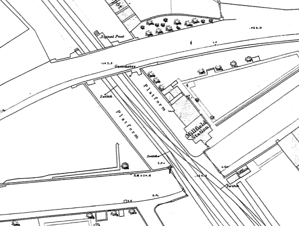
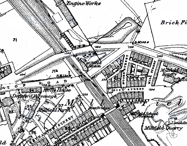
Notes: Millfield station opened with the Leamside – Sunderland route in 1853. At that time the streets and industries of Sunderland had sprawled westwards in a haphazard fashion, and a limb of urban development stretched out as far as Millfield; there was still a tract of countryside between the town and Millfield station, and beyond it the land was largely rural, but with pockets of industry. Immediately north-west of Millfield station was an engine works reached from the west by a siding on the down side of the line. By the last decade of the century streets of terraced housing had engulfed the line from Sunderland to Millfield.

The original site of the station was immediately north-west of the Hylton Road crossing, but the road was later diverted to a bridge over the railway immediately north-west of the station. The station building was on the down (Sunderland-bound) platform. It was a two-storey house, gable end-on to the railway with a canted bay window abutting the platform ramp and then a range continuing north-westwards, stepped back along the platform. Some dignity was given to the building by a generous roof overhang and the use of stone quoins. Fawcett suggests that the building originally had an attic-style first floor, later raised to full height, evidence being in the differential weathering of the bricks. It is not clear from Ordnance Survey plans what buildings were provided on the up platform.

In February 1863 Bradshaw shows eight weekday calls by up trains on weekdays and three on Sundays. In the opposite direction there were seven on weekdays and three on Sundays. By summer 1896 the service had increased to 10 up on Monday-to-Friday, 11 on Saturdays, but still three on Sundays. Down train calls amounted to 12 on Monday-to-Friday, 13 on Saturdays, and four on Sundays. Three of the down weekday trains called by request to set down passengers from stations south of York. By this time Millfield had a new station on a new site.

BRIEF HISTORY OF THE SUNDERLAND TO DURHAM (AND BISHOP AUCKLAND) VIA LEAMSIDE LINEDespite its name the Durham & Sunderland Railway (D&S) – not via Leamside – never did reach Durham City. Its route from South Dock, Sunderland, extended through Murton to Haswell (where the Hartlepool Dock & Railway Company already had a terminus) which opened in 1836, with a branch from Murton through Hetton, Pittington and Sherburn House to Shincliffe, two miles south-east of the Durham City centre, which opened in 1839. The North Eastern Railway eventually diverted the line from Shincliffe to terminate in Durham at Elvet station in 1893.


In an Act of 27 July 1846 the Newcastle & Darlington Junction Railway (see ‘Old Main Line’ history) was authorised to build a line from Pensher (later known as Penshaw) to join the D&S Railway at Sunderland. The line was known as the Painshaw Branch (another variation on the spelling of Penshaw). From Sunderland as far as Penshaw the line followed the River Wear valley but its route was generally some distance from the river to avoid a meander near Hylton and to serve the communities which were growing south of the river. The line opened on 20 February 1852 for goods traffic and 1 June 1853 for passengers. The terminus in Sunderland was Fawcett Street station, which opened on the same day on the southern edge of the developing commercial centre of the town.

The Bishop Auckland branch from Leamside via Durham opened to passengers on 1 April 1857. Beyond Leamside, at Auckland Junction (later known as Leamside Junction) it swung westwards from the route to Ferryhill, crossed the River Wear on a viaduct, then sharply south-west to reach Durham City. The curious dog-leg in the route enabled the line to follow the intended course of the moribund YN&B project of 1848: see details in the section below on the ‘new’ main line. Durham City’s centre is densely built up on the narrow, steep-sided peninsula within a meander of the River Wear, dominated by the cathedral and castle; the railway did not enter this historically important area, but passed by to the north-west, where a substantial viaduct was necessary and the city’s station was found.

The Leamside – Bishop Auckland branch now provided an alternative route between Durham and Sunderland, far more convenient than via the Durham & Sunderland’s Shincliffe (for Durham) terminus – which was abandoned in 1893 when the D&S was re-routed to a terminus at Durham Elvet. On the day the Bishop Auckland branch was opened the branch from Belmont Junction to Durham Gilesgate closed to passengers: this had been opened by the N&DJ on 15 April 1844, providing the first station in Durham City.

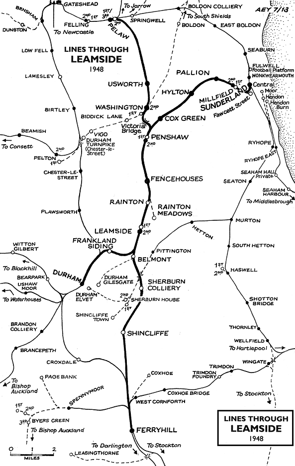
From 1857 Leamside station enjoyed some importance as the de facto junction where trains to and from Sunderland and Durham connected with the services on London Kings Cross – Newcastle – Edinburgh main line. Fencehouses or Penshaw could equally have been awarded this status, but Leamside station, in its remote rural surroundings, was rebuilt with an island platform and bays at each end to accommodate the connecting services and allow convenient interchange by passengers. Its importance was short-lived and was suddenly removed when the new main line route between Ferryhill and Newcastle via Durham opened in 1872. Leamside station was now an extravagance, with little local population to serve; conversely the splendid Durham viaduct, originally serving only the Leamside – Bishop Auckland branch, was now a prominent feature of the main line providing a vantage point from which millions of passengers would be able to admire Durham and its cathedral.


In Sunderland the inconvenient gap between Monkwearmouth, the terminus of trains from Newcastle and South Shields on the north bank of the River Wear, and the lines from the south was closed in 1879 when in the ‘Monkwearmouth Junction’ project a bridge over the river and a tunnel under the town centre were constructed together with a new station known either as Sunderland (or Sunderland Central). From August 1879 Fawcett Street station closed and trains on the Durham line ran into the new station. The Central station also replaced the Hendon terminus, formerly used by trains to Seaham and West Hartlepool.

As with most lines in northern County Durham the Sunderland – Durham route carried large quantities of goods and mineral traffic, notably coal. Several collieries were directly linked to the line, and there were branches into shipyards and Deptford staiths on the Wear as well as to the Hudson, Henson and South docks on the coast.

Expecting that coal exports from Sunderland’s South Dock would increase, the North Eastern Railway and local authorities jointly funded the construction of the Queen Alexandra Bridge, to carry both rail and road traffic in the manner of High Level Bridge between Gateshead and Newcastle. The NER paid £325,000 (including railway approaches) while Sunderland Corporation contributed £146,000 and Southwick Council a further £11,000. The new bridge and associated lines would enable coal from the ex-Stanhope & Tyne line to reach South Dock, eliminating reversals at Washington and Penshaw, using instead a mineral line from Southwick Junction (between Washington and Boldon) over the new Queen Alexandra Bridge, then the Sunderland – Durham line from Diamond Hall Junction (just west of Millfield station). The bridge opened in 1909, but from the NER perspective it was a financial disaster since it apparently carried one coal train per day until the early 1920s when regular traffic ceased.

Passenger services on the Sunderland – Durham line remained frequent. However from the 1920s motor buses began to provide a more intensive service and linked the numerous mining villages and towns in north-east Durham. The ‘Old Main Line’ south of Leamside lost its passenger services in 1941. On the Sunderland – Durham route, apart from the very early loss of Frankland station, between Leamside and Durham, in 1877, casualties began with Leamside in 1953, followed by Millfield in inner Sunderland in 1955. Diesel multiple units replaced steam haulage on the route during 1957.

Further economies were exercised when Pallion and Penshaw were downgraded to ‘staffed halts’ and Cox Green became an ‘unstaffed halt’ on 14 August 1961. Passenger traffic censuses in summer 1962 and winter 1962-3 showed a respectable level of use on Monday-to-Friday of Hylton and Pallion stations, but limited traffic at the other stations, notably Cox Green. The Reshaping of British Railways (‘Beeching’) report of March 1963 recommended the withdrawal of passenger services between Sunderland, Durham and Bishop Auckland - as well as the services between Newcastle and Washington - and the official proposal of closure was published on 19 July 1963. Not a single objection was lodged to the Washington closure, which took place on 9 September 1963. BR must have been unprepared for the lack of resistance to this closure as a timetable for Usworth and Washington stations appeared in the winter 1963-4 North Eastern Region book. On 28 February 1964, having considered objections to the Sunderland – Durham – Bishop Auckland proposals, Ernest Marples, Minister of Transport, consented to the closure, and services were officially withdrawn on 4 May 1964.

he author was blissfully unaware of this development, and alighted from a Newcastle train at Durham on 15 May to catch the Sunderland train, only to be informed that the last one had gone! He decided to travel on to Darlington and Middleton-in-Teesdale instead – which was still open.

Goods services ceased between Leamside (Auckland Junction) and Durham (Newton Hall Junction) and at Finchale siding (Frankland) on 22 October 1964. The tracks into the former Fawcett Street terminus in Sunderland, which had continued as a goods facility reached from the Durham line, were severed on 3 October 1965. Goods services were retained between Penshaw and Sunderland until 21 August 1967 when they were discontinued west of Hylton Quarry sidings. In 1971 the line from Pallion to Ford paper works at Hylton was singled and ceased to be signalled when the factory closed, but Dolomite from Hylton Quarry continued to be carried until 1976 when the line was cut back to Pallion; it was officially taken out of use on 20 November 1976. The remainder of the line to Hendon, including Deptford Johnson Siding closed to goods on 27 November 1984. The section of the ‘Old Main Line’ which the Sunderland – Durham services shared between Penshaw Junction and Auckland Junction continued in goods use for some years more, but was ‘mothballed’ in 1991 and closed in 2012.

Sources and bibliography:

Bradshaw from Chris Totty. Route maps drawn by Alan Young.

To see other stations on the Old Main Line click on the station name: Felling 2nd, Felling 3rd , Felling 1st, Pelaw 1st, Pelaw 3rd, Pelaw 4th , Pelaw 2nd, Usworth, Washington 2nd, Washington 1st, Penshaw 1st, Penshaw 2nd, Fencehouses, Rainton, Rainton Meadows (on branch), Leamside 1st, Leamside 2nd, Belmont Junction, Durham Gilesgate (on branch), Sherburn Colliery, Shincliffe & Ferryhill

See also Coxhoe (branch from Ferryhill)

See also: Springwell, Brockley Whins (1st site), Brockley Whins (2nd site)
& Boldon (route prior to 1850)

See also Sunderland and Durham (via Leamside):
Durham (still open), Frankland, Cox Green, South Hylton , Hylton, Pallion 1st, Pallion 2nd , Millfield 1st, Millfield 3rd , Sunderland Fawcett Street (on branch) & Sunderland Central (Still open)


Station still open as part of the Tyne & Wear metro


The building at the first Millfield station is seen c1880 in this view looking north. Hylton Road formerly had a level crossing here as shown by the gate where the people have gathered. The 1860 plan indicates that this building had a short extension towards the south-east, set back from the bay window; the differential shading of the brickwork suggests the shape of a pitched roof reaching the level of the first essentially a single-storey structure but with an attic-type upper floor. The building on the right with a first-floor jetty is the signal box.

1860 1:528 OS town plan. Millfield station is shown here in 1860, only seven years after it opened. In this short time the Hylton Road level crossing immediately south-east of the station had been abandoned and the road re-routed over a bridge to the north-west which straddled the platforms. The station building is seen on the down (Sunderland-bound) platform adjoining the former level crossing, and the large scale of this plan allows some elements of the building’s layout to be seen. No building is shown on the up platform, where the majority of passengers would be expected to alight from trains rather than waiting to board them and buy tickets. The platforms end with steps rather than ramps at their north-west end. In 1890 the station was rebuilt to be entirely north-west of the road bridge.

1871 1:2,500 OS map. Millfield station is shown in its urban and industrial context. Amidst the high density terraced housing and old farm and parsonage have survived. A brick field, quarry and engine works are shown close to the station. The station building is shown on the north-east (down) platform, but no structures are shown on the up platform. In 1890 the station was rebuilt to be entirely north-west of the road bridge.

In April 1962, although both the first and second Millfield stations were closed to passengers they were substantially intact. A low platform, station buildings and signal box on the right belong to the first station, and sidings in the goods yard are seen to the left. Straddling the railway track, adjoining Hylton Road bridge is the building containing Millfield second station’s entrance and offices, whilst its platforms are visible beyond the bridge. The view is north-westwards.
Photo by Brian Johnson

The signal box and building of Millfield first station are seen from a westbound train in 1964.
Photo by Roy Lambeth

The building at Millfield first station is seen in April 1967, looking north. The brickwork at the south-eastern end has been rendered.
Photo by JM Fleming

In July 1976 the station building appears to be in a derelict condition. This view is looking east.
Photo by Alan Lewis from his Ipernity photo gallery


Looking north at the derelict building of Millfield first station in 1978. It would soon
be extended and restored.
Photo by Alan Lewis from his Ipernity photo gallery

In July 1993 the old station building at Millfield is in use as a public house. This view is looking north.
Photo by Alan Lewis from his Ipernity photo gallery

Looking north-west along the course of the Sunderland to Penshaw line towards Millfield station. The building belonging to the first station, open to passengers from 1853 until 1890 is right of centre, heavily restored, painted white with black quoins, and operating as a public house. The sloping tarmac path leads up to Hylton Road.
Photo by Alan Lewis from his Ipernity photo gallery

In April 2003 a Metro train arrives at the new Millfield (third) station which has been constructed to the south-east of Hylton Road bridge on the site of the first station. The road bridge has been rebuilt in association with Metro works as it must give clearance for the overhead electric supply to the trains.
Photo by Alan Young

Recent aerial view showing the site of the first Millfield station which is now occupied by the new Metro station. The original alignment of Hylton Road is now an access road for the Metro. There was originally a level crossing here. The road on the other side of the crossing has been obliterated by the Aldi store car park. The second Millfield station was on the north side of the road bridge.

1977

1977

August 1988

2001

Click on thumbnail to enlarge


[Source: Alan Young]


Last updated: Sunday, 21-May-2017 15:41:04 CEST
© 1998-2013 Disused Stations