
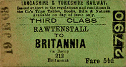
Station Name: BRITANNIA[Source:
Alan Young]
Britannia Station Gallery 1: Early 20th Century - 1959 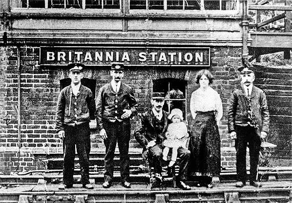 Only the signal box at Britannia appears to have been photographed before the station closed in 1917. Its position is about 50yd west of the station, on the up side of the tracks. Commenting on this photograph, Jeffrey Wells (1993) suggests that it dates from World War 1, and he draws attention to the severed arm of the man on the left as well as to the confidence of the party that no train is due since they are standing and seated on the up line. It would be interesting to know the identity of the four railwaymen, the woman and the child.
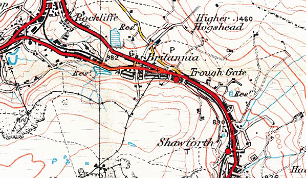 
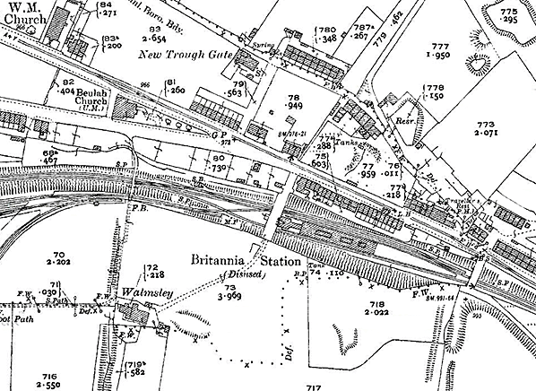
1910 1: 2,500 OS map. Uniquely among the intermediate stations on the Facit Branch, Britannia had an island platform. The booking hall is shown east of the road overbridge, and the shaded area includes the staircase (covered?) down to the platform and the awning which extended about half the length of the platform is shown by pecked lines. The small buildings beneath the awning are also marked. Sidings are located to the west on the down side (south of the running lines) and a standard gauge tramway extends southwards off the map to serve some small coal pits and the Britannia Quarries. The signal box is identified between the two overbridges west of the platform. Some of the neighbouring terraces are shown to be ‘back-to-back’, including the cluster on Market Street close to the bridge at the east end of Britannia station. The road south of Beulah Chapel is called ‘New Line’, referring to the adjacent railway: it was ‘new’ in comparison to the Irwell Valley route to Bacup and the Rochdale-Facit section. The village of Britannia, named after an inn, includes scattered terraces and two Methodist churches. Unless they were employed in the mills, many of the men of the village will have trekked uphill to work in the quarries or pits each day. In the year after this map was published a street tramway, connecting Rochdale and Bacup, was opened and it followed Market Street immediately north of Britannia station. Click here for a larger version.
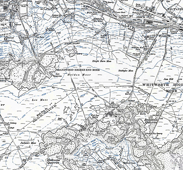
1912 1:10,560 OS map. By the early twentieth century the moors south and west of Britannia were extensively quarried for flagstones which were removed via the various mineral railways. Britannia station is in the north-east corner of this map extract, and the steeply inclined mineral railway which carried the stone from the moorland quarries is seen striking south-westwards from the station. On the moor top there are numerous individually-named quarries, collectively known as Britannia Quarries, and a number of abandoned coal workings (some identified as ‘Old Shaft’). A branch from the line connecting Britannia station and quarries follows a near-level route to Lee Quarries, from which a steeply-graded tramway leads down to a point between Stacksteads and Bacup in the Irwell valley. After being moribund for many years the quarries on the tops are now active again, but the railways have long gone. Click here for a larger version
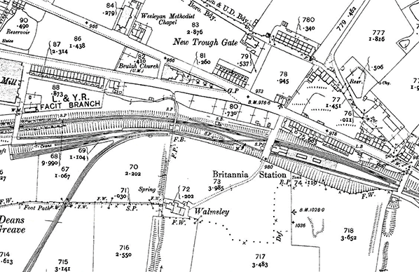
 1939 1: 2,500 OS map. Although Britannia station is labelled ‘Disused’ the booking hall and the buildings and awnings on the platform are still shown – there is even an extra building on the platform that was not shown on the 1910 map. The sidings west of the station are unchanged since 1910. The electric tramway along Market Street connects Rochdale and Bacup: it had closed in 1932.
Click here for a larger version 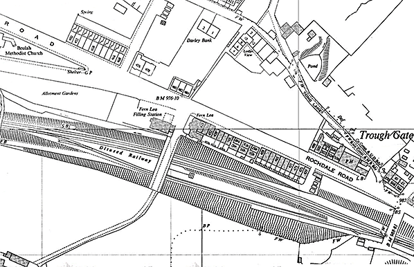
1960 1: 2,500 OS map. The survey probably dates from the mid 1950s. The railway is now shown to be disused and sidings have been removed. Britannia station’s platform is shown but the northern (up) face has lost its edge stones as a slope is shown rather than a crisp edge: photo evidence confirms that this had happened. A fragment of the staircase is the only other structure surviving at the station. On the moors beyond this map extract to the west and south some quarries have now closed and are being used for disposal of refuse. Click here for a larger version.
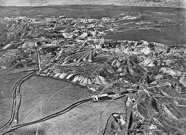 An oblique aerial photograph from August 1926 of the Facit and Britannia quarries on the moor top west of the Facit Branch. North-west is at the top of the photograph. A mineral line is seen entering the photo at the bottom, whilst the line connecting the quarries to Britannia station is visible as the dark line curving, then running straight to leave the image below the top right corner.
Click here for a larger version 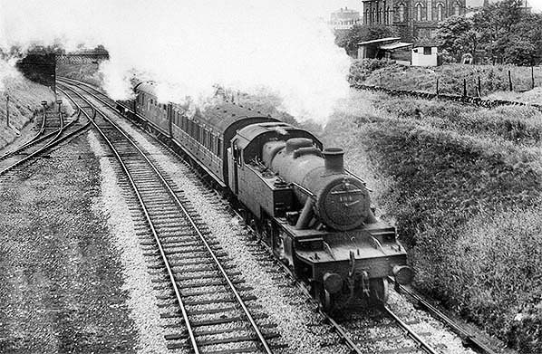
This is a rare photograph of a passenger train working the Facit Branch before it closed. It was taken in June 1947, the month in which passenger services were withdrawn from the line. LMS No.194,a Stanier 2-6-2T, is hauling a 3-coach train from Bacup and is about to pass the disused station at Britannia; the view is from the bridge from which the station, directly behind the photographer, was entered. The same train was photographed by W A Camwell crossing Healey Dell Viaduct south of Shawclough & Healey station. Beulah Methodist church is the prominent building in the background. Bacup shed had a small allocation of these Stanier 2-6-2T locomotives for use on the line; when passenger services finished they were moved away, largely to Southport. The loco was classified 3P, meaning Class 3 Passenger. Withdrawals began quite early and the class became extinct during 1962 and none survived. No.194 became BR No.40194 and lasted until October 1961 when withdrawn from 27C, Southport shed. In July 1962 she was cut up by the Central Wagon Co, Ince, Wigan. Click here to compare this view with the same view today.
Photo by W A Camwell 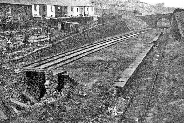
The single island platform at Britannia is seen in 1956, looking east. The station closed in 1917. Part of the stone staircase leading down from the bridge is still in place. By this time the railway track on the right (the original down line) has been abandoned, and the up line on the opposite face of the platform has been reclassified as the down line, its neighbouring loop becoming the up line. The headshunt and connection with the new up line can be seen beneath the bridge beyond the platform. The edge stones have been removed adjacent to the new up line in case they were to fall onto the track from the derelict platform. Officially both of the tracks to the left have been closed since 1952, but for a further 11 years they would be retained in case they were needed for wagon storage.
Photo by Tom Wray 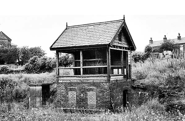 The signal box at Britannia closed in 1949 and is photographed here c1956. The structure was erected in 1881 and is a size 1 Gloucester Wagon Co design. At the time of the photograph the levers are still in place. The box was demolished in 1962/63.
Photo by Tom Wray 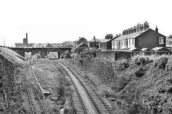
Looking west from Old Lane bridge at the island platform of the long-closed Britannia station in August 1961. The down (left) side of the platform is intact but, owing to the removal of the edge stones on the opposite side, that part of the platform is degraded. Vegetation has colonised the platform and is also engulfing the tracks. At the far end of the platform a lamp standard is still in place. The lower part of the staircase up to the site of the booking hall can be seen in the distance. The booking hall was at road level, but no evidence can be seen of it as the parapet now extends between the two bridges where it was located. The up and down lines and the down side loop are all still in place; the down line (left of the platform) was abandoned in 1944 and the other two lines were reclassified, so the up main line became the ‘down’ and the loop became the ‘up’ line. The building on the skyline beyond the left bridge is Britannia cotton mill, still in use by a textiles firm. The Classical building with the prominent pediment is Beulah Methodist church, now converted into apartments.
Photo
by Ian G Holt
Looking east from the north bridge on the lane to Walmsley across the site of Britannia station towards Old Lane bridge on 17 August 1961. The station closed to passengers in April 1917; it never handled goods traffic. The broad island platform was originally sheltered by a large awning, and the booking office was at road level, immediately right of the camera. However, these buildings were demolished during the LMS era (1923-47). The flagstones of the platform are overgrown and its up (left) side is degraded owing to the removal of the edge stones. Both the old up line and the loop that pass below the bridge are seen, but vegetation conceals the old down line to the right of the platform. Although disused since 1952 the rails have been left in place in case needed for wagon storage. The substantial retaining walls were necessary as the shale and glacial clays are prone to slippage. The two terraces to the left of the photo are on Rochdale Road
Photo by Ian G Holt 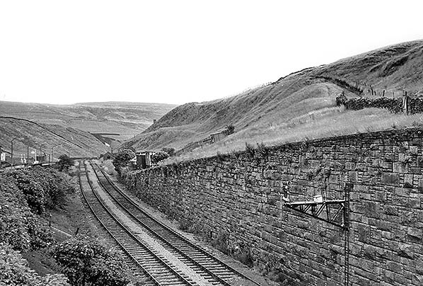
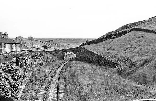
Looking south-east from Old Lane bridge towards the 967ft summit of the Rochdale–Bacup line in August 1961. The platform of Britannia station is behind the camera. The summit – the highest point on the entire Lancashire & Yorkshire Railway – is close to the platelayers’ hut on the down (right hand) side of the line beyond the lowest level of the retaining wall. At that point the rising gradient of 1 in 193 abruptly changes to a falling gradient of 1 in 40: the LYR gradient diagram states 1 in 250, but the sign still in place in 1961 reads 1 in 193. Rochdale Road and Shore Service Station (still operating in 2016) are seen to the left. The photograph was taken in August 1961. Click here to compare this view with the same view today.
Photo by Ian G Holt 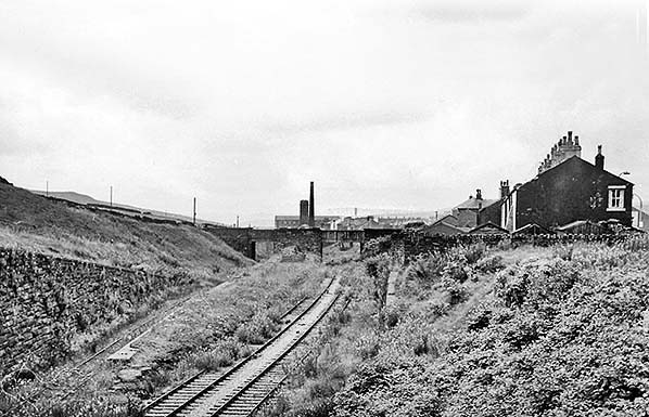 In August 1963 the scene at Britannia is little changed from two years earlier when Ian Holt took a series of photographs here. This view is westward from Old Lane, and the overgrown island platform of Britannia station is flanked by two lines on the up side and single line on the down side; it is understood that officially the nearest track, formerly the up loop, was reclassified as the up (main), and its neighbour, formally the up main became the down line in 1944, and that the far track – formerly the down line- was abandoned. As seen here in 1963 the rails were left in place after official closure in 1952 to be used, if needed, for wagon storage. The edge stones have been removed from the near side of the platform resulting in the collapse of the backfill, but the opposite side is largely intact. At the far end of the platform are the remains of the staircase which led up to the booking hall, long since demolished, at bridge level. The large building in the distance is Britannia Mill.
Photo by Ben Brooksbank 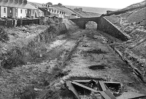
Looking east across the remains of Britannia station towards Old Lane bridge in September 1971. Passenger trains used this line between Rochdale and Bacup until 1947, but Britannia station closed in 1917 as an economy measure during World War 1; a request in 1926 by local firms for it to be reopened was unsuccessful. The rails were removed by the end of 1964 having been left in place for 12 years after the line was closed. The overgrown island platform is still clearly visible, but the removal of its edge stones has caused it to degrade. The pile of huge stones in the foreground is likely to be the edge stones. The photographer is standing on the overbridge at the site of the station’s booking hall, and a flight of steps formerly descended to the platform, where there were further buildings and a large canopy which extended for almost half the length of the platform. From this viewpoint nothing can be seen of the station today (2016) as the cutting has been filled in.
Photo
by John Mann
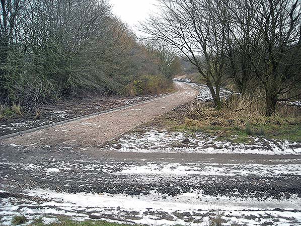
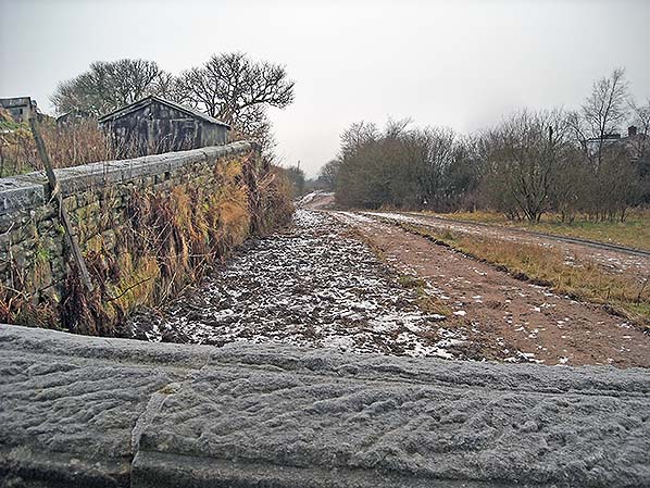
Looking east from the former bridge at Britannia in January 2016 the viewpoint is similar to John Mann’s view of September 1971 above. The cutting has been filled in, the remains of Britannia station have been buried and for some years a path has followed the line of the railway.
Photo by Alan Young
Click here for a series of 34 pictures taken around Britannia station site and the Britannia quarries in 2016
|
 Unlike the neighbouring double-track roadside stations at Facit and Shawforth, Britannia was given an island platform in a cutting; Wray (2004) remarks that it was ‘quite elaborate for a station in a relatively remote location’. The booking hall was on the east side of an over-line bridge, and a stone staircase led down to the flagstone platform which was sheltered by a verandah for over half of its length. Details of the platform buildings have not been, but Marshall (1970) notes that the platform buildings at Britannia station were similar to those at Bacup. Since the glazed roofing provided at the neighbouring 1881 Bacup and Shawforth stations and on Facit’s down platform building was of a ridge-and-furrow design, it would follow that Britannia, being contemporary with them, would have had the same style.
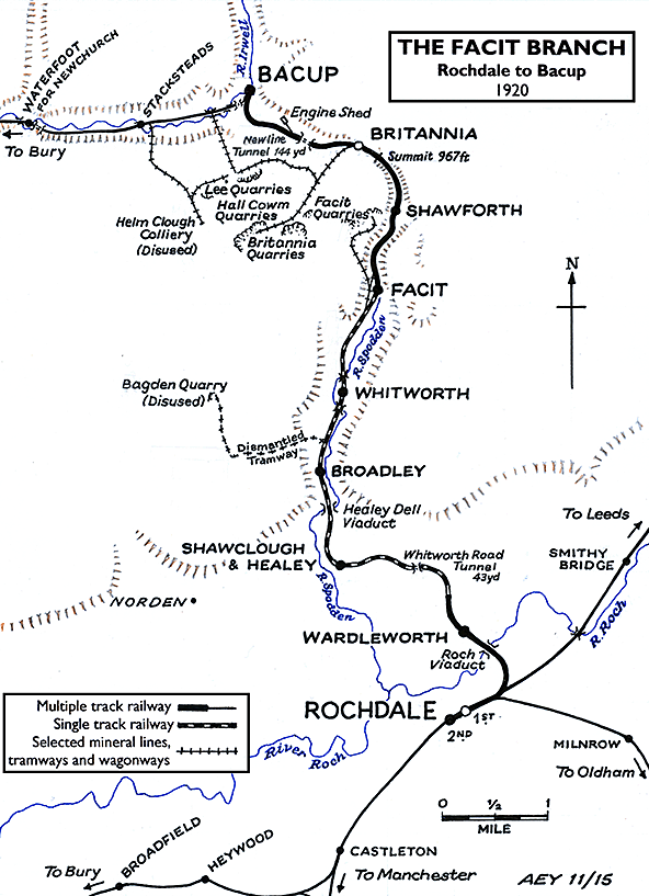
 Looking west from Old Lane across the infilled site of Britannia station in January 2016. A gravel path now conveys walkers some 20ft above the level of the old station platform. The parapet of Old Lane bridge is in the foreground and the upper part of a retaining wall of the former railway
 Home Page