
Station Name: BRITANNIA[Source:
Alan Young]
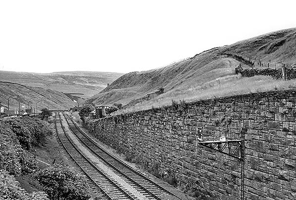
Looking south-east from Old Lane bridge towards the 967ft summit of the Rochdale–Bacup line in August 1961. The platform of Britannia station is behind the camera. The summit – the highest point on the entire Lancashire & Yorkshire Railway – is close to the platelayers’ hut on the down (right hand) side of the line beyond the lowest level of the retaining wall. At that point the rising gradient of 1 in 193 abruptly changes to a falling gradient of 1 in 40: the LYR gradient diagram states 1 in 250, but the sign still in place in 1961 reads 1 in 193. Rochdale Road and Shore Service Station (still operating in 2016) are seen to the left. The photograph was taken in August 1961. Click here to compare this view with the same view today.
Photo by Ian G Holt 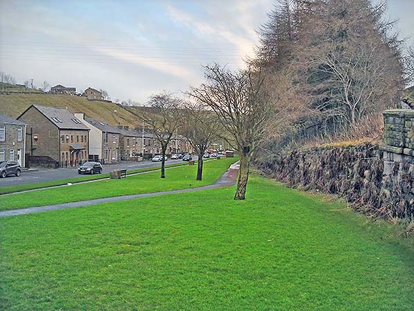 Looking south-east from Old Lane bridge in January 2016 from a similar viewpoint used by Ian Holt in his photo of August 1961 above. The former cutting has been filled in for about a quarter of a mile, so the site of Britannia station (behind the camera) is now about 20ft below the surface and the massive retaining wall (right) has largely been buried. The 967ft summit of the Rochdale – Bacup line is ahead, a short distance beyond the end of the retaining wall. At that point the former railway trackbed was on a rising gradient of 1 in 193 that abruptly changed to a falling gradient of 1 in 40. Rochdale Road and, in the distance, Shore Service Station are seen to the left; the service station can also be seen on the 1961 photograph, Click here to returm to previous page. Looking south-east from Old Lane bridge in January 2016 from a similar viewpoint used by Ian Holt in his photo of August 1961 above. The former cutting has been filled in for about a quarter of a mile, so the site of Britannia station (behind the camera) is now about 20ft below the surface and the massive retaining wall (right) has largely been buried. The 967ft summit of the Rochdale – Bacup line is ahead, a short distance beyond the end of the retaining wall. At that point the former railway trackbed was on a rising gradient of 1 in 193 that abruptly changed to a falling gradient of 1 in 40. Rochdale Road and, in the distance, Shore Service Station are seen to the left; the service station can also be seen on the 1961 photograph, Click here to returm to previous page.Photo by Alan Young
|
 Home Page