
Station Name: ROCHDALE (First Station)[Source:
Alan Young]
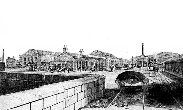 This engraving is understood to date from the late 1840s and it shows the original Rochdale station, looking north-east from Moss Lane bridge. The view is from one of the sidings giving access to the two-road engine shed (just right of centre) and the goods warehouses – the tall structures, centre and towards the left side of the picture. The two tracks of the main line enter the picture from the right edge. The passenger station building is the single-storey structure with a pitched roof and canopy, just left of centre. To reach the minimalist, rail-level platform for northbound (down) trains passengers must first walk across the sidings; an engine is seen taking water at the column just beyond the platform. The up platform, for trains to Manchester, is seen far right. It is of a more conventional height than the down platform and a canopy provides shelter to the two waiting passengers. This station underwent alterations over the following decades but closed in 1889 when the present-day Rochdale station replaced it. The details on this engraving can be compared with the large-scale OS plan of 1851.
Image from Jeffrey Wells collection 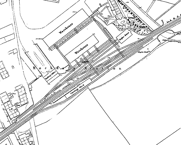
1851 1: 1,056 OS map. It is fortunate that the Ordnance Survey produced this excellent large-scale plan, even though the station was some way from Rochdale town centre. The ‘Railway Office’ (containing the booking hall) is set back from the double-track main line, and separated from it by sidings en route to the goods warehouses and ‘Engine House’ (loco shed). The two passenger platforms are shown, that on the up (south-east) side having a series of dots indicating posts to support the canopy, and being backed by the carriage shed. No footbridge is installed, so passengers leaving the booking office and wishing to catch trains towards Littleborough, Todmorden and points beyond have to ensure that it is safe to cross some sidings before they reach the shelterless down platform; if they are travelling to Manchester they then have to summon up the courage to walk across both main line tracks. Two goods warehouses of substantial size are named, and access to them for railway wagons is shown to be via turntables with ‘secondary’ sidings at 90⁰ to the sidings which branch from the main lines. Two secondary sidings cross the main line as they connect sidings behind the up platform with the goods warehouses. Click here to see a larger version.
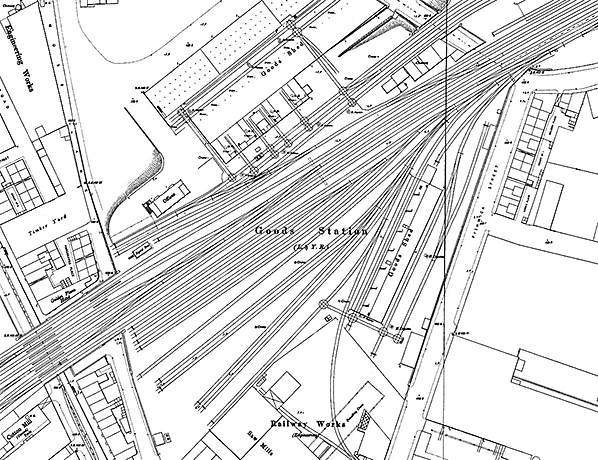 Apart from the station building the original station, closed in 1889, has been swiftly demolished to enable its site to be incorporated into the greatly enlarged ‘Goods Station (L&YR)’. An ambitious development of sidings and a railway workshop have been added on the up side, encompassing the site of the former up passenger platform and the carriage shed. A goods warehouse has also been added on the up side. To the north-east are Milnrow Road Coal Sidings (constructed in 1884), identified as ‘Mineral Yard’ on the map, plus a further goods shed. Click here to see a larger version.
1894 10:10,560 (6") OS map. first2.jpg)
The ‘Railway Office’ of the first Rochdale station survived for many decades after its closure in 1889, and it is seen here in August 1956. The building is apparently in use by permanent way staff, judging by the stack of flagstones beside the door. Its structure is remarkably unambitious considering the rising importance of the industrial town that it served. It is a single-storey affair of no architectural distinction, brick-built with rendering which is crumbling. The view is southwards from the old forecourt approached via Railway Street. A canopy formerly extended from the far side of the building. The structure, far right, is a shed within Rochdale station’s goods yard. The photograph appears to have been taken on the occasion of an enthusiasts’ visit to the station, judging by the attire of the men (far left and foreground) and the presence of a young boy at the scene. No record has been found of a railtour calling here in August 1956.
Copyright photo from John Alsop collection first3.jpg)
The ‘railway office’ of the first Rochdale station survived for many decades after its closure in 1889, and it is seen here in August 1956. The building is apparently in use by permanent way staff, judging by the stack of flagstones beside the door. Its structure is remarkably unambitious considering the rising importance of the industrial town that it served. It is a single-storey affair of no architectural distinction, brick-built with rendering which is crumbling. The view is southwards from the old forecourt approached via Railway Street. A canopy formerly extended from the far side of the building. The structure, far right, is a shed within Rochdale station’s goods yard.
Photo from Jeffrey Wells collection / Lancashire & Yorkshire Railway Society first10.jpg) Looking north-east from the Roch Valley Railway Society’s ‘Salford Hundred Railtour’ train on 28 July 1962 between Rochdale and Wardleworth. The train has left the main line at Rochdale East Junction and is approaching the bridge over a trackway about 100yd north-east of the junction. Since 1960 the up (far right) track has been out of use. No.52523 is hauling the train in the down direction to Facit; No.40063 would head the train back to Rochdale.
Photo by Ian G Holt first13.jpg) On 27 June 1987 the Pathfinder Tours’ ‘Aintree Hurdler’ is approaching the site of Rochdale 1st station from the north-east, having started its journey at Bristol and just visited the Oldham Loop. The loco is BR 58 042 ‘Ironbridge Power Station’. A fleet of 50 such Class 58 locos was constructed for use on MGR (‘Merry-go-Round’) trains conveying coal to power stations in the Nottinghamshire area. This loco entered service in May 1986 and was withdrawn in April 2002. Having been exported to France in August 2009 it is currently stored out of use. On 27 June 1987 the Pathfinder Tours’ ‘Aintree Hurdler’ is approaching the site of Rochdale 1st station from the north-east, having started its journey at Bristol and just visited the Oldham Loop. The loco is BR 58 042 ‘Ironbridge Power Station’. A fleet of 50 such Class 58 locos was constructed for use on MGR (‘Merry-go-Round’) trains conveying coal to power stations in the Nottinghamshire area. This loco entered service in May 1986 and was withdrawn in April 2002. Having been exported to France in August 2009 it is currently stored out of use.Photo by David Ingham from his Flickr photostream first14.jpg)
Looking south-west from Rochdale signal box on Saturday 12 March 1988. The site of Rochdale (1st) station is immediately behind the photographer. BR English Electric (Vulcan Foundry Ltd-built) Class 40 diesel-electric locomotive No.40122 of Crewe Diesel TMD is crossing Moss Lane bridge on the down main line, hauling BR Class 97/2 Bo-Bo electric heating unit number 97252 ‘Ethel’No.3 of Old Oak Common TMD on the Pathfinders Railtours' Taunton to Liverpool Lime Street 'The Pennine Forty Farewell' charter (1Z36). It is formed of 5354, 5386, 5494, 17058, M1644, 13488, 5444, 5360, 5264, 6609 of which it was in charge between Stockport and Crewe. From Rochdale the train should have run via Wakefield Kirkgate, Methley Junction, Whitehall Junction, Dewsbury, Huddersfield, Manchester Victoria and Earlestown to Liverpool Lime Street, but was diverted at Earlestown to run via Warrington Bank Quay to Crewe in an attempt to make up lost time.
Photo by David Ingham from his Flickr photostream 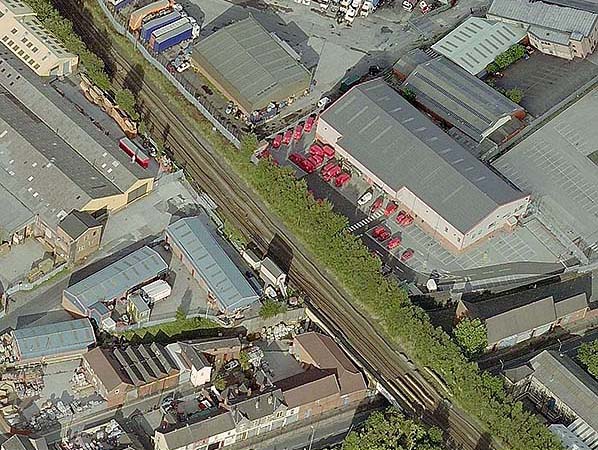
A recent aerial view of Rochdale (1st) station site. The present Rochdale station is several hundred yards along the track that disappears at the bottom of the picture over Moss Lane bridge. The road entering the view from the left between the modern industrial units is Railway Street, the original station approach road. The site of the station building is the darker tarmac area, partly in shadow. Rochdale signal box is between this site and Moss Lane bridge.
first11.jpg) Looking south along Railway Street in February 2016, the lane composed of stone setts that led to the original Rochdale station and which now gives access to a small industrial estate. The site of the station building was just before the crest of the hill. On the far side of the metal fence are the tracks of the Manchester Metrolink line between Newbold and Rochdale Railway Station and, beyond, the National Rail line between Smithy Bridge and Rochdale.
Photo by Alan Young first12.jpg)
The site of the original Rochdale station at the southern end of Railway Street in February 2016, now just a stone-sett lane leading into a small industrial estate. The former station building was located ahead and to the right of the picture corresponding to the area of tarmac. To the south, on the far side of the metal fence, are the tracks of the Manchester Metrolink line between Newbold and Rochdale Railway Station tram stops and, beyond, the National Rail line between Smithy Bridge and Rochdale.
Photo
by Alan Young
|
 On the opposite side of the line a wooden shelter was constructed c1843. A map of 1851 and engraving of the late 1840s show that up and down platforms were provided, but that access to them from the booking office (‘Railway Office’ on an early plan) entailed a walk across sidings to reach the rail-level down platform, without any shelter, and across the two ‘main line’ tracks to reach up platform as no footbridge was installed.
 1851 10:10,560 (6") OS map.
 Home Page