
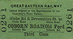
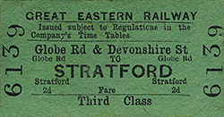
Station Name: GLOBE ROAD & DEVONSHIRE STREET[Source: Nick Catford]
Globe Road & Devonshire Street Station Gallery 1: Early 20th C - 1931 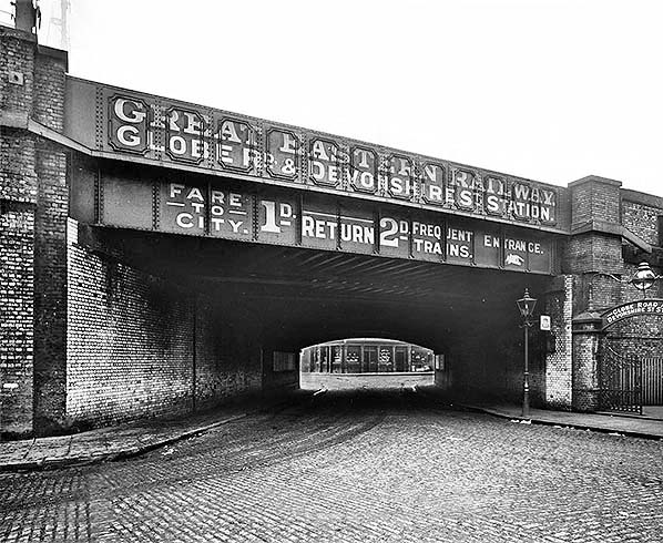 The bridge over Morpeth Street, with the station entrance on the right and thus looking south, sometime in the very early twentieth century. Morpeth Street bridge carried, and indeed still does carry four tracks. There was also a siding terminating at buffers adjacent to Globe Road bridge. Part of the siding remained in use into the 1980s for sand traffic in conjunction with the adjacent (at the east end of the site) Regents Canal and has latterly been used for the stabling of on-track plant. The groun- level site of the goods yard is now built on having closed in 1967. It was on the north side of the line and road access to the yard was along the road seen in the left foreground. The bridge marks the boundary between Mile End and Bethnal Green. In this photograph Devonshire Street runs right to left beyond the bridge with Portelet Road veering left straight ahead. The arched section of the bridge is believed to date from the original Eastern Counties Railway line. The flag fixed to the bridge abutment on the right appears to bear the bell logo of the National Telephone Company (NTC). The NTC was taken over by the GPO (General Post Office) in 1911, suggesting that the photograph may predate that year. Note the delightful globular gas lamp over the station entrance. Through the entrance gates there was a subway under the viaduct taking passengers to the Devonshire Street booking office. The standard mounted lamp uses an early form of incandescent mantle; an upright type, meaning that it is mounted at the bottom and supported at its top by a wire frame. Today the arched section of the bridge remains but the girder section now uses concrete beams. The cobbles have long gone, although probably still exist beneath the tarmac, as have the gas lamps and the station entrance ornate gates on the right. The gatepost still stands, however, and some of the glazed bricks beneath the bridge can still be seen. The building seen beyond the bridge is The Carlton public house. Formerly The Carlton Arms; it dates from 1854 at which time its address was 2 Devonshire Street. In 1861 the address was 2 Carlton Terrace, Devonshire Street and it later became 238 Devonshire Street. Still there today, the address is now 238 Bancroft Road, E1. Devonshire Street no longer exists or at least not in name. It ran east from Cambridge Heath road, the first section now being part of Cephas Street, before turning north-east along what is now Colebert Avenue. It then crossed Globe Road before turning eastwards to run parallel the railway before joining Bancroft Road which runs south-east to eventually join the Mile End Road. Precisely when Devonshire Street, the name, ceased to exist is unclear but the process appears to have begun shortly before the war and to have been completed by, or immediately after, the end of the war. True to form, however, to this day the railways still refer to Devonshire Street in their track and signalling diagrams. Click here to see a larger version of this picture with a more detailed caption.
Photo from John Mann collection 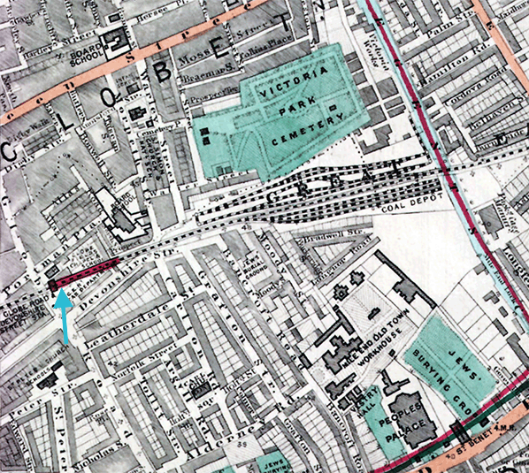
 1876 1:2,500 OS map. This map shows the original layout of the Devonshire Street goods yard before the yard expanded onto the south side of the viaduct. At this time Globe Road and Devonshire Street station had not been built and the viaduct was yet to be widened. The steep incline trailing in from the down line is highlighted in yellow. Small turntables for moving wagons around the yard are shown at both ends of the lower yard and in the centre. At the east end of the yard a siding runs alongside the Regents Canal for transhipment of goods between the canal and railway. Two cranes are shown in the centre of the lower yard with another alongside the Regents Canal. Wagon turntables are also seen at the east end of the upper yards. The upper yard comprised a series of coal drops with the coal depot located beneath the viaduct. There was no direct rail access to the depot with coal being transferred to road vehicles. Access to the lower yard was at the end of Warley Street and access to the coal depot was at the north end of Bancroft Road. Weighbridges are shown at both entrances. A signal box is shown but not named at the west end of the yard on the up side. Click here for a larger version. 1876 1:2,500 OS map. This map shows the original layout of the Devonshire Street goods yard before the yard expanded onto the south side of the viaduct. At this time Globe Road and Devonshire Street station had not been built and the viaduct was yet to be widened. The steep incline trailing in from the down line is highlighted in yellow. Small turntables for moving wagons around the yard are shown at both ends of the lower yard and in the centre. At the east end of the yard a siding runs alongside the Regents Canal for transhipment of goods between the canal and railway. Two cranes are shown in the centre of the lower yard with another alongside the Regents Canal. Wagon turntables are also seen at the east end of the upper yards. The upper yard comprised a series of coal drops with the coal depot located beneath the viaduct. There was no direct rail access to the depot with coal being transferred to road vehicles. Access to the lower yard was at the end of Warley Street and access to the coal depot was at the north end of Bancroft Road. Weighbridges are shown at both entrances. A signal box is shown but not named at the west end of the yard on the up side. Click here for a larger version.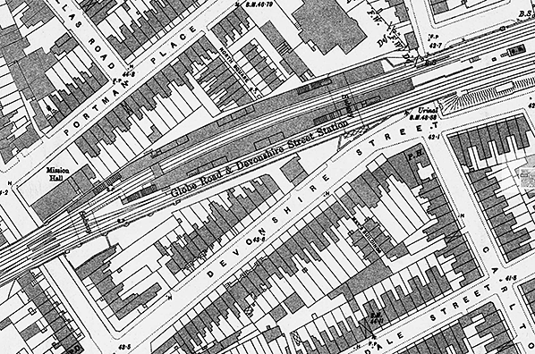 1896 1:1056 OS Town Plan. This map shows the layout of Globe Road station as built. There are two facing platforms which are slightly staggered. They are covered by a canopy for most of their length but the canopy is not shown here. There were entrances at both ends of the station. The Globe Road entrance gates are show immediately south of the bridge. The booking office was located in the first arch which is indicated here by a subway. The canopy in front of the entrance is not shown. A triangular compound on the north side of Devonshire Street is the entrance to the Devonshire Street booking office located in the second arch west from the bridge; here the small canopy in front of the entrance is shown. On the north side of the Morpeth Street bridge another entrance gateway is shown with a path leading to the subway. The four stairways are shown; staggered stairs at the Grove Road end and facing stairs at the Devonshire Street end. The room layout of the platform buildings is clearly seen. There are three blocks of buildings on the up platform with a gents' toilet at either end. The first two buildings (left to right) are waiting rooms and ladies’ rooms. The third building is the stationmaster's office and other staff rooms. The down platform has two blocks of buildings comprising waiting rooms and ladies rooms with a gents' toilet at the west end. The Grove Road Junction signal box is shown spanning the tracks towards the west end of the station. The Devonshire Street signal box is seen between the tracks to the east of the down platform. This box was opened in 1884 and replaced and earlier box nearby.
Click here for a larger version. 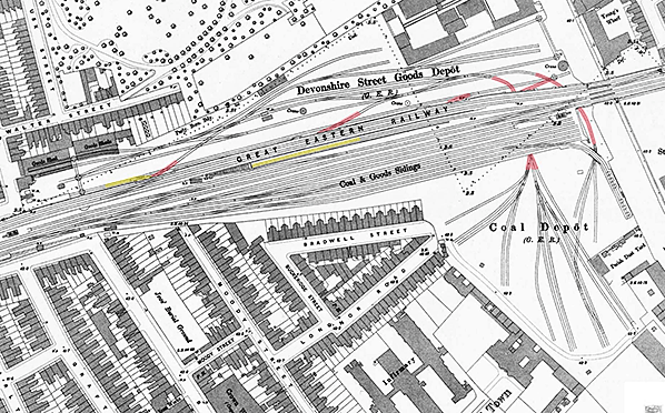
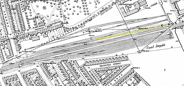
1896 1:1056 OS Town Plan. There have been many changes in the layout of the goods yard since the 1876 map. The incline (indicated in yellow) to the lower yard on the north of the viaduct has been rebuilt further west. It trails of the down fast line and immediately dives under the new lines to emerge in the lower yard. It is clear from this map that the headshunt at the foot of the incline was nowhere near long enough to accommodate a train of more than, perhaps half a dozen wagons. Much of the north yard has been re-laid and a number of lines (indicated in red) are seen passing beneath the viaduct. Two of these, at the east end, emerge on the south side of the viaduct to serve an extension of the yard on that side; the other three do not emerge on the south side and would have served the coal depot located below the viaduct. These are likely to have been connected to another line running under and parallel to the viaduct but there is no documentary evidence of this. The yard on the south side of the viaduct handled coal and building materials. As well as the original entrance to the south side, at the north end of Bancroft Road there is also an entrance with a weighbridge (WM) at the end of Longnor Road. The entrance to the yard on the north side at the end of Warley Road now has two weighbridges. The Devonshire Street coaling stage is seen on the edge of the embankment just west of the Bancroft Street weighbridge (by the letters F.A.). The siding alongside the Regents Canal at the east end of the north yard has now gone but an elevated siding continues off the end of the viaduct running above other sidings to serve coal chutes alongside the Regents Canal on the south side. Two signal boxes are shown: Devonshire Street at the west end of the yard and Canal alongside the Regents Canal. Click here for a larger version.
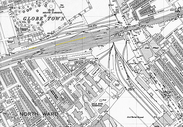
1950 1:2,500 OS map. The final extension to the goods depot occurred just before WW1 when further land on the south side of the viaduct was acquired to provide space for five long sidings served by car roads. The main road access to the enlarged yard was from Mile End Road just west of the Globe bridge over the Regents Canal. The elevated siding running alongside the Regents Canal has gone. Devonshire Street West signal box closed 5.9.1948 and iis not showd so is assumed to have been quickly demolished The East box (formerly Canal) closed 6.2.1949 but is still shown. A Corporation Yard has opened within the goods yard alongside the Regents Canal. In the north yards most of the wagon turntables have gone leaving just two at the east end of the yard. Click here for a larger version
 From Railtrack's Waterloo Archive
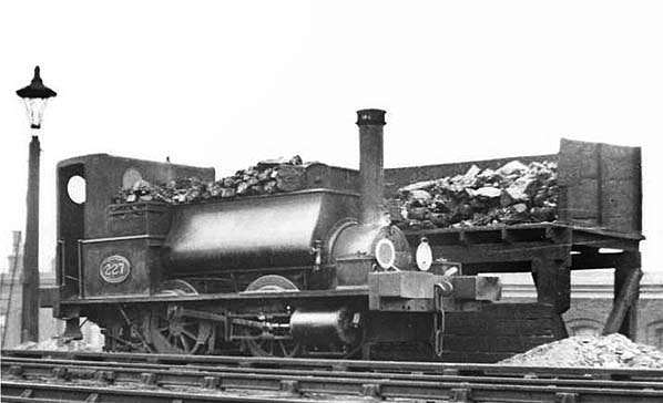
GER 209 class No.227 stands at the Devonshire Street coal stage, with ash pile on the right, in the early 20th century. There were eight of these diminutive locomotives, nicknamed 'Coffee Pots' and those which survived into LNER days becoming Class Y5. Originally a standard Neilson 0-4-0ST with open cabs, the first two, Nos.209 and 210 were purchased 'off the shelf' in 1874/5. Their purpose was shunting at Devonshire Street and the Pepper Warehouses at Blackwall (accessed from Canning Town and often referred to as such). The coaling stage seen in this view was located at the west end of Devonshire Street goods yard on the edge of the embankment and on the south side of the main line. The stage was abolished circa 1957 when diesel shunters took over. Click here to see a second picture of the coaling stage and a more details description of the 'Coffee Pots.'
Photo from James Lake collection 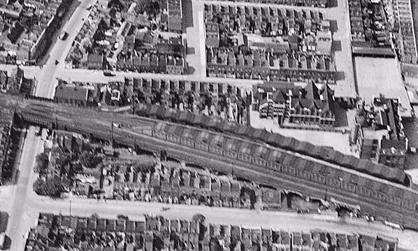
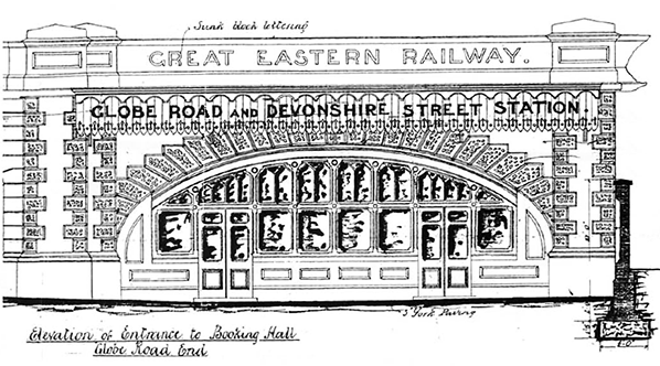
Aerial view of Globe Road & Devonshire Street station seen from the south in 1931, 15 years after the station closed. Devonshire Street runs left to right across the picture. Morpeth Street bridge is seen on the far right and to its left is the entrance to the Devonshire Street booking office with the parapet above the arch being rendered with Portland cement. Great Eastern Railway appears in recessed letters in the render; see drawing above. This section of the viaduct (only the south side) is now Grade II listed as it is among the earliest, and longest, examples of a first-generation railway structure to survive in London.
Photo from Britain from Above, reproduced with permission 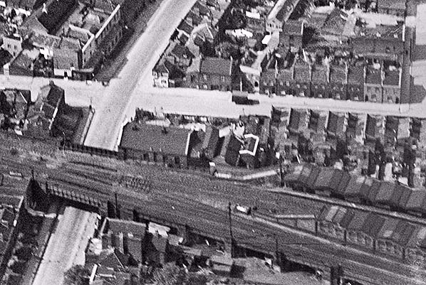 Aerial view of the east end of Globe Road & Devonshire Street station seen from the south in 1931, 15 years after the station closed. The Globe Road booking office is located in the first arch east of the Globe Road bridge. The two staggered stairways are roofed with panes of rolled ribbed glass. The was no entrance on the north side of Globe Road bridge as the Globe Road Mission Hall butts up to the viaduct. At the other end of the station there are entrances on both sides of the line.
Photo from Britain from Above, reproduced with permission 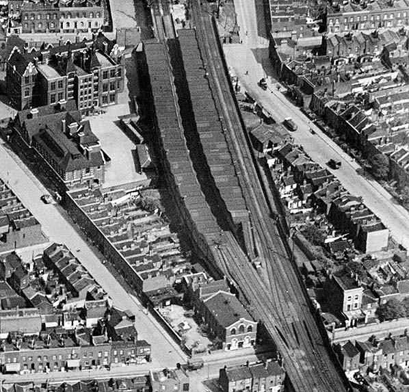
Aerial view of Globe Road & Devonshire Street station seen from the east in 1931, 15 years after the station closed. The station remained largely intact until demolition in 1938. The Grove Road Junction box which was sited above the tracks towards the London end of the station has been demolished. It closed in 1894 and was probably demolished soon after closure. Photo
from Britain from Above, reproduced with permission
Click here for Globe Road & Devonshire Street Station Gallery 2: 1931 - June 2017
|
 By 1840 it was clear that additional money would be required to complete the ECR line to Colchester. On 25 February 1843 a special inspection train left Shoreditch for Colchester. However, the train was stopped at Brentwood as a timber viaduct at Mountnessing had subsided and it was unsafe to continue. On 7 March 1843 goods trains started operation followed by the commencement of passenger services on 29 March 1843.
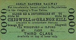 On 28 June 1884 the new station was inspected by Major C S Hutchinson on behalf of the Board of Trade. In his report, he described it as having ‘a very elaborate character’. On 29 June, the quadrupled line was brought into use and on 1 July 1884 Globe Road & Devonshire Street station was opened; it was 1 mile 54 chains east from Liverpool Street and close to the site of the former Devonshire Street terminus which had closed in 1840.
 At track level there was a generous range of facilities on both platforms. The buildings were of timber construction. The up platform had three buildings in which the facilities were, from west to east: gents’ toilet, general waiting room, first/second class waiting room, drinking fountain, bench seat, first class ladies’ room, second class ladies’ room then the stairs down to the Devonshire Street entrance. Beyond the stairs was a third range of buildings which comprised the stationmaster’s office, porters’ room, lamp room, store and another gents’ toilet.
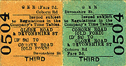 At some time the Devonshire Street goods yard was expanded at ground level on the south side of the viaduct. It was entered initially via a wagon turntable giving access to a line that passed through one of the viaduct arches. This was soon replaced by a sharply curving line which passed under the viaduct towards the east end of the yard with a second line passing round the end of the viaduct alongside the Regents Canal. A short elevated line also ran off the end of the viaduct passing over one of the lines running under the viaduct before running south along the canal bank. This served chutes for loading coal directly onto canal boats. Another line ran diagonally under the centre of the viaduct to serve the coal depot that was located beneath the viaduct.
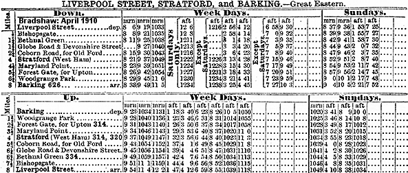
 The need for cut-down locomotives at Devonshire Street was reduced headroom beneath a bridge carrying the main line over the tracks linking the north and south side goods sidings. However, whether this problem existed with just one bridge or all them remains unclear. Also unclear is whether the reduced headroom limited the ground level sidings on the south side to flat and open wagons and this question cannot be answered without knowing how many bridges were affected. One of the Y4s, No.210, was to enter departmental service at Stratford Works. At nationalisation she became British Railways No.68129 and in 1952 became Departmental No.33. She was destined to become the final survivor of the class, the rest having gone between 1955 and 1957, finally bowing out in December 1963. She was also among the final surviving British Railways locomotives to have dumb buffers. Shunting at Devonshire Street, by then known as Mile End Yard, was taken over by examples from the motley collection of diesel shunters on Stratford's books. Photographs of locomotives, steam or diesel, at Devonshire Street/Mile End have proved frustratingly elusive but one of the diesel shunters known to have worked at the location was the Brush 0-4-0 D2999. Others likely to have made appearances are Rustons D2957/8 and Barclays D2953-6; all of these would have been able to negotiate the low bridge(s) and sharp curves found in the yard. Click
 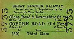 The area around Globe Road and Devonshire Street came through WW2 largely unscathed but the immediate surroundings did not, and railway staff reputedly had to jump into the adjacent canal to avoid fire on one occasion. Damage by conventional HE (High Explosive) bombs and incendiaries was too vast to be detailed here but worthy of mention are attacks by V1 Flying Bombs in the immediate vicinity of the goods yard. There were three such attacks. One V1 decided to dive very close to the south side goods viaduct and destroyed a house on the corner of Bradwell Street and what was then Buckeridge Street (now part of Moody Street) and damaged others to extents varying from serious to minor. Part of the goods viaduct was also damaged but quickly repaired. Another V1 came down on the corner of Bancroft Road and Moody Street destroying at least one house, severely damaging others and causing damage to the Jews' Burial Ground (not to be confused with the nearby Jewish Cemetery). A third V1 came down on the south side of Mile End Hospital, very close to the Jewish Cemetery and the railway sidings on the site of what is now Queen Mary University. Conventional bombings and V1 attacks were horrific enough but fortunately the immediate environs of the Devonshire Street goods yard were to escape attacks by V2 rockets. The first V1 attack on London occurred further east adjacent to Grove Road bridge and not at Globe Road. A blue plaque is fixed to Grove Road bridge and it is not unknown for 'blue plaque tourists' to confuse the locations and erroneously look for a blue plaque at Globe Road
 Home Page