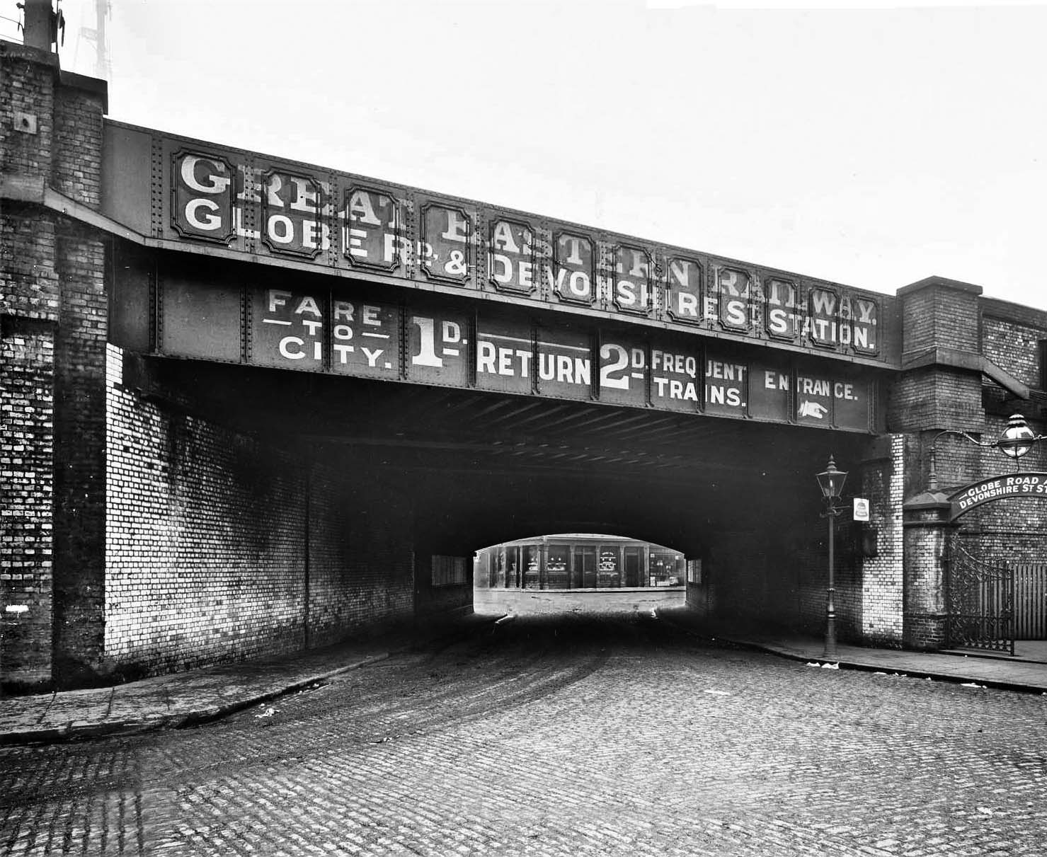
The bridge over Morpeth Street, with the station entrance on the right and thus looking south, sometime in the very early twentieth century. Morpeth Street bridge carried, and indeed still does carry four tracks. There was also a siding terminating at buffers adjacent to Globe Road bridge. Part of the siding remained in use into the 1980s for sand traffic in conjunction with the adjacent (at the east end of the site) Regents Canal and has latterly been used for the stabling of on-track plant. The bridge over Morpeth Street, with the station entrance on the right and thus looking south, sometime in the very early twentieth century. Devonshire Street had briefly been the original Eastern Counties Railway broad gauge (5ft) terminus of its line from Romford from 20 June 1839 until the line was extended the following year to Shoreditch. The temporary terminus seems to have stood at the junction of Globe Road and what was then Devonshire Street. The ground level site of the goods yard, which was once a haunt of the rather odd-looking and poorly designed Class Y4 0-4-0T's, is now built upon having closed in 1967. It was on the north side of the line and road access to the yard was along the road seen in the left foreground. The site is today Meath Crescent, on the southern edge of Meath Gardens - the former Victoria Park Cemetery. Morpeth School stands out of view to the right of the photographer and the bridge marks the boundary between Mile End and Bethnal Green. In this photograph Devonshire Street runs right to left beyond the bridge with Portelet Road veering left straight ahead. The arched section of the bridge is believed to date from the original Eastern Counties Railway line. The flag fixed to the bridge abutment on the right appears to bear the bell logo of the National Telephone Company (NTC). The NTC was taken over by the GPO (General Post Office) in 1911, suggesting the photograph may predate that year but many of these 'bell' signs survived for a great many years afterwards. The NTC had its origins with the Bell company of the USA, hence the bell logo, and the text on the signs said Public at the top and Telephone at the bottom. The centre text depended upon the type of telephone service provided and although totally unreadable here its length suggests it says 'Long Distance'. Quite where the telephone was located is unclear but it would either have been just inside the gates on the right or, more likely, at the station itself. Note the delightful globular gas lamp over the station entrance. The standard mounted lamp uses an early form of incandescent mantle; an upright type, meaning it is mounted at the bottom and supported at its top by a wire frame. Once inside the station entrance gates passengers would have walked through a subway under the viaduct to reach the Devonshire Street booking office. Today the arched section of the bridge remains but the girder section now uses concrete beams. The cobbles have long gone, although probably still exists beneath the tarmac, as have the gas lamps and the ornate gates on the right. The gatepost still stands, however, and some of the glazed bricks beneath the bridge can still be seen. The building seen beyond the bridge is The Carlton public house. Formerly The Carlton Arms, it dates from 1854 at which time its address was 2 Devonshire Street. In 1861 the address was 2 Carlton Terrace, Devonshire Street and it later became 238 Devonshire Street. Still there today, the address is now 238 Bancroft Road, E1. As those unfamiliar with the area's history will have by now realised, Devonshire Street no longer exists or at least not in name. It ran east from Cambridge Heath road, the first section now being part of Cephas Street, before turning north-east along what is now Colebert Avenue. It then crossed Globe Road before turning eastwards to parallel the railway before joining Bancroft Road, that is the original section of Bancroft Road which runs south-east to eventually join the Mile End Road. The section of the former Devonshire Street north-east of Globe Road today forms a continuation of Bancroft Road. At the Cephas Street end, part of the course of Devonshire Street as far as what is now Colebert Avenue is lost beneath postwar developments and consequent alterations to road layout, the area being badly bombed during the war. In wandering the streets off Cambridge Heath Road today, attempting to visualise the area as it once was is extremely difficult. Precisely when Devonshire Street, the name, ceased to exist is unclear but the process appears to have began shortly before the war and completed by or immediately after the end of the war. True to form, however, to this day the railways still refer to Devonshire Street in their track and signalling diagrams.
Photo
from John Mann collection

 Home Page