Notes: The Eastern Counties Railway was incorporated in 1836 to link London with Ipswich via Colchester, and then extend to Norwich and Yarmouth. At that time this was the longest line sanctioned by a single Act of Parliament with a total length of 126 miles.
Construction began in late March 1837 on the first nine miles at the London end. John Braithwaite was the as engineer and the gauge was set at 5ft compared to the national standard of 4ft 8½in. Progress east of Stratford was relatively easy as the land was largely arable. West of Stratford, the line had to cross the unstable Bow Marshes and after that the built-up nature of the area meant that the railway had to be built on expensive viaducts. The London Viaduct carried the line from Devonshire Street, Mile End to the terminus at Shoreditch, a length of 2.300 yards.
The viaduct was to be built in stages, the first stage running from the embankment which ended at the junction of Morpeth Street and Devonshire Street to Cambridge Road where a temporary station would be built to allow the line to be opened between there and Romford. Encouraged by the speedy construction of the line between Mile End and Romford, the ECR committee decided in August 1838 that they would abandon plans for a temporary station and push on towards Shoreditch in order to open the completed line at the earliest opportunity. The contract for the first section was awarded to Thomas Curtis and Sons from Stratford.
By January 1839 such good progress had been made at the Romford end that the company decided that all four sections of the viaduct should be constructed simultaneously in an effort to reach Shoreditch and Romford at the same time. The enthusiasm was dampened when an unexpected shortage of funds led to the contracts for the viaduct being suspended on 30 March 1839, forcing the company to revert to is earlier plan for a temporary station at Cambridge Road. However as three of the cast-iron bridges on the viaduct had not been completed there was yet another change of plan when on 7 May 1839 the directors agreed to build a temporary station at Devonshire Street to allow a service to Romford to begin.
The construction of a second temporary station at Brick Lane was considered in March 1840 but it was decided instead to open the line to Shoreditch as soon as possible. On 1 July 1840 the ECR opened an extension at the London end to its permanent terminus at Shoreditch (renamed Bishopsgate in 1846). Although Shoreditch had opened, Devonshire Street station remained open as an intermediate station.
On 2 March 1841 the ECR committee discussed removing Devonshire Street station to Dog Row (near Cambridge Road, now Cambridge Heath Road) which refers to the site of Mile End station, soon to be opened. The committee was told that an engineer would report on the probable cost the following week. On 29 April 1841 the committee minutes state, 'Remove such part of Devonshire St. Station as needed to establish station at Cambridge Rd.; additional work to be done by tender at least possible expense.'
Devonshire Street never appeared in Bradshaw and was probably replaced by Mile End or closed shortly after Mile End opened around the end of May 1841. It is unlikely that Mile End and Devonshire Street would have been open at the same time as the stations were very close to each other.
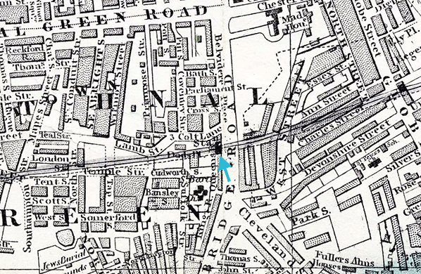
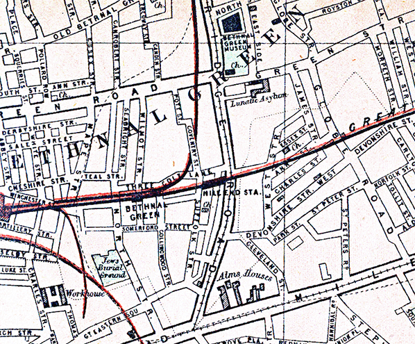
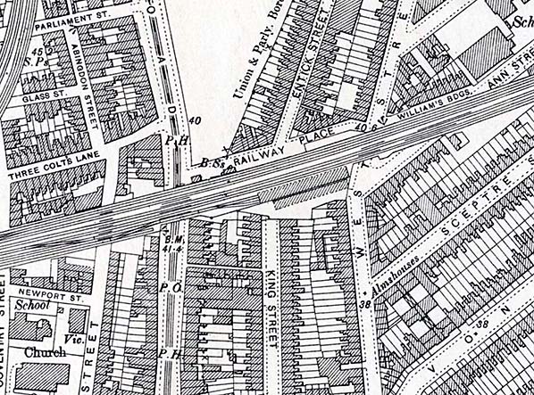
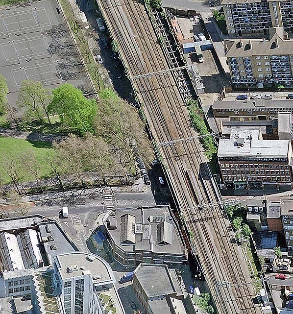
Mile End was station located on the viaduct where it crossed Cambridge Road (now Cambridge Heath Road). The exact position cannot be positively determined from surviving documents. Mile End station does not appear on any Ordnance Survey maps; it came too late for the first edition and by the time the second edition was published it had closed. It is shown on some pre-1870 street maps and on the two below it is shown on the west side of Cambridge Road. Some published sources, however, state that it was on the east side of the road.
The 1876 1:2,500 OS (the survey for the map was made in 1870, the year Mile End closed) map suggests that the station might have straddled the Cambridge Road bridge. This is perhaps confirmed by a minute of the ECR Engineering & Traffic Committee on 27 April 1858 which recorded that a handrail should be fitted on the bridge parapet. It is likely that some trains may have stopped at Mile End by request only. On 25 January 1854 the ECR committee decided that the 3pm train from Shoreditch would start at 3.15pm and call at Mile End when required.
In 1856, staff at the station were, a stationmaster (Mr Boswell), booking clerk, porter, signalman and telegraph signal boy for day duty. In August 1867 an assistant booking clerk was also employed. On 15 January 1856, Mr Boswell was brought before the committee charged with being absent from his station, together with the only porter employed there, at 8.30am that day. During dense fog the 8.40am Enfield up train was left standing unprotected on the main line; Mr. Boswell stated that he had too much to do to attend to his work properly (hours 6am to 10pm daily). He was admonished and told to be more careful and keep the porter at the station during his absence. On 3 February 1858 Boswell was dismissed for neglect following another incident; the new stationmaster was a Mr Shepherd. On 12 May 1858 a Mr Lovitt, a carriage attendant at Bishopsgate, was suspended for breach of regulations. He resigned and then sought reinstatement; he was made inspector at Mile End which was a higher grade than carriage attendant! Mr Boswell was again being discussed by the GER committee 15 July 1863 so he must have been reinstated. The superintendent reported irregularities by Mr Boswell and a deficiency of £12-1s-0d in the accounts; he was dismissed [again].
The station was provided with two short, narrow platforms with buildings on the down platform and a signal box at its west end. Minutes of the various ECR committees, and, to a lesser extent, GER committees have a number of references to improvements to be made at Mile End station; the more interesting ones are noted below.
23 August 1850: Mile End up platform to be extended 50ft and extra lamp installed. Apparently, some trains were too long for the platforms and passengers sometimes had to alight on the track. 22 March 1854: Close-boarded fence about 6ft high to be erected at Mile End station, to extend as far as coal pits for security of passengers alighting from long trains. This suggests that trains longer than the platforms could accommodate did call at the station, but it could merely refer to poor or non-existent lighting. 3 May 1854: Seats to be supplied to waiting rooms, furniture to the ladies’ room and a better water supply to the closet.
12 March 1857: It was reported that some parcels were received at, and forwarded from, Mile End station by passenger trains, but as very few long trains called there because of the short platforms parcels were liable to a transit delay. The committee agreed that all parcel traffic should be transferred to Bishopsgate.
27 April 1858: A handrail on bridge parapet was required on up side and also at the bottom of the stairs. Platform ends are to be sloped; an absence of ramps was common practice at the time. 5 June 1861: The London end of both platforms are to be stepped down and handrails provided; also a bracket lamp is to be fitted on the up side. Cambridge Heath Road bridge parapet is to have a handrail fitted. This appears to suggest that the 'sloping ends’ authorised in 1858 were never built or, if they were, they were built only at the country end. Likewise the handrail for the bridge parapet authorised might not yet have been fitted.
In 1860 the Clerk to Mile End Old Town Council asked the ECR if Mile End station could be resited to Devonshire Street; this was before Globe Road station opened. The request was turned down on 21 November that year.
Bradshaw had a note that trains would not call at Mile End during foggy weather. A letter from a TH Pinchin of Thornton Heath published in the Great Eastern Railway Magazine in October 1912 describes the facilities at Mile End station in 1856, ‘My chief resided at Lea Bridge and in the course of my duties I had to go from the Mile End station which was an ugly wooden building, a short platform about 12ft wide; no covering, and for waiting room a square box not much larger then a huge packing case, so on wet days when an extra amount of passengers were present it was not an unusual thing to get damp while waiting for the train. It seems strange now to compare the stations to the elaborate ones now viz., Globe Road and Coborn Road.
The ECR committee also discussed the provision of a coal depot with coal drops to the east of the station on the down side. 24 June 1846: A coal siding is to be added at Mile End station; the passenger station would need to be altered according to the resident engineer’s suggestion to accommodate this. There is no further reference to this siding or where it was to be placed but it is assumed to be the siding on the up side east of Cambridge Road which is shown on various OS maps. The coal siding is not mentioned again until 27 March 1850: Northumberland & Durham Coal Co to pay 2d per ton terminal charges on all coals brought to Mile End or Shoreditch in lieu of rent.
8 March 1854: All the coal cells are to be given up for inland coal trade, a triangular piece of ground on south side of line is to be walled in with a proper shed as the place for a summer store; the road in front of the present cells is to be properly paved. 27 April 1858: Coal shoots are to be covered (ECR refers to coal shoots; GER calls them coal drops).
On 27 May 1872 the GER opened a new branch from Liverpool Street to Hackney Downs. This followed the Eastern Counties line to Bethnal Green where it branched north just before Mile End station. On Friday 24 May Mile End station was closed and was replaced by Bethnal Green Junction station 400yd to the west which opened on the same day. The coal depot remained open and is still shown on maps into the 1950s. It is not known when it closed.
Three fatal accidents were recorded at Mile End station. The first was reported to the committee on 12 May 1858. A grocer, Mr Bothby, fell on the stairs. He was sent to hospital, discharged himself and died later. The actual date of the accident was not recorded. The second accident occurred on 3 April 1859. A passenger tried to board the 6.30pm ex-Enfield and fell between the platform and carriage and was severely injured. He died the next morning in the London Hospital. An inquest returned a verdict of accidental death. On 2 October 1865 Porter May fell down and his leg was run over requiring amputation. Obviously May did not survive the amputation as, on 20 December 1865, £10 awarded to the widow of Porter May killed at Mile End.
On 27 May 1872 the GER opened a new branch from Liverpool Street to Hackney Downs. This followed the Eastern Counties line to Bethnal Green where it branched north just before Mile End station. On Friday 24 May Mile End station closed and was replaced by Bethnal Green Junction station 400yd to the west which opened on the same day.
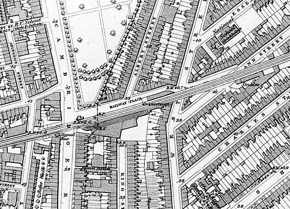
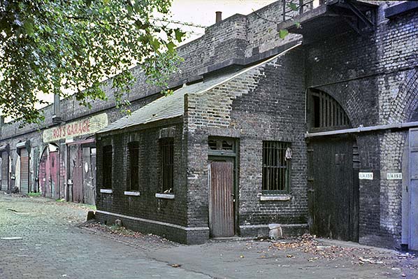
The arches in the viaduct between Cambridge Heath Road and Malcolm Road are all in commercial use. In the 1990s coal depot on the south side of the viaduct was a builder's yard. By 2003 it was used to store vehicles but these had gone by 2013. The yard which had an entrance in Malcolm Road (formerly West Street) is now derelict and the wooden gates have been replaced by a brick wall.
A section of the north side of the Former Eastern Counties Railway London Viaduct, from the east side of Cambridge Heath Road to the west side of Globe Road, was Grade II listed by English Heritage (now Historic England) on 3 September 2007. This stretch of viaduct is architecturally the most handsome, with finely tooled masonry bridge openings and balanced rows of arches showing the influence of neo-classicism. The viaduct is of great significance as a surviving structure from the first generation of railway building.
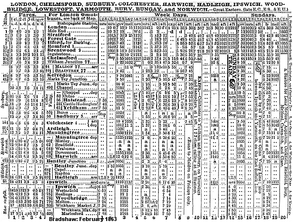
Bradshaw from Alan Young.
Click here for a rear cab view video Mile End - Liverpool made by Nick Belton in June 2017. The sites of Devonshire Street & Mile End goods yard, Devonshire Street station, Globe Road & Devonshire Street station, Mile End station and Bishopsgate Low Level station are all seen.
Sources:
- Minutes, records and other documents of the Eastern Counties Railway & Great Eastern Railway
- Great Eastern Railway Society Journal 20. The Early Stations - Bishopsgate to Stratford - A Preliminary Survey by G. Creighton
- Great Eastern Railway Magazine. October 1912
See Also: Globe Road & Devonshire Street, Devonshire Street, Coborn Road (2nd) & Coborn Road (1st) |


 Home Page