|
Notes: The small town of Tow Law stands on an exposed hilltop on the edge of the North Pennines about 10 miles to the west of Durham. Until 1841 there was no settlement here of any size, only a single home, Tow Law House.
The development of Tow Law as a town started in 1845 when Charles Atwood took advantage of the local supply of iron ore and built an iron works close to Tow Law House. Six years later, the population has increased to over 2000 (the current population) and by 1880 there were over 5000 people living there.
Six blast furnaces were built and they were fuelled by coal from the nearby collieries. Although Atwood's iron works closed by 1882 with production being switched to his other iron works at Spennymoor the town continued to expand from the early settlement around the iron works.
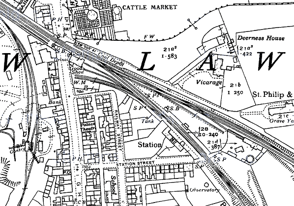
 When the Crook to Tow Law railway deviation was under construction it was originally planned as a double-track line but was built with only one track with the option of doubling at a later date. By early 1867, the new Tow Law station was under construction with a single platform to allow the line to be opened at the earliest opportunity. The deviation opened to goods traffic on 10 April 1867 but could not open to passengers until inspected and approved by the Board of Trade. This inspection took place on 17 June but the inspector, Col. Rich, was not satisfied and he refused to sanction the opening of the line. A second inspection took place on 19 July but the inspector, Col. Hutchinson, made it clear that the Board did not approve of single platforms on busy lines. Despite continued objections from the North Eastern Railway they had no option but to construct a second platform, and the line was again inspected by Col. Rich on 27 February 1868 when approval to open was finally granted. When the Crook to Tow Law railway deviation was under construction it was originally planned as a double-track line but was built with only one track with the option of doubling at a later date. By early 1867, the new Tow Law station was under construction with a single platform to allow the line to be opened at the earliest opportunity. The deviation opened to goods traffic on 10 April 1867 but could not open to passengers until inspected and approved by the Board of Trade. This inspection took place on 17 June but the inspector, Col. Rich, was not satisfied and he refused to sanction the opening of the line. A second inspection took place on 19 July but the inspector, Col. Hutchinson, made it clear that the Board did not approve of single platforms on busy lines. Despite continued objections from the North Eastern Railway they had no option but to construct a second platform, and the line was again inspected by Col. Rich on 27 February 1868 when approval to open was finally granted.
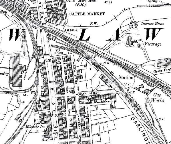
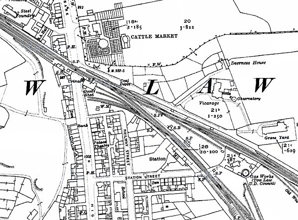
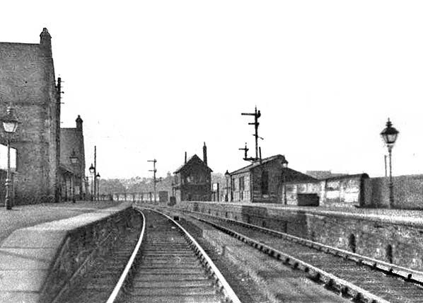
The main station building was on the down side. It was built in a Gothic style in local sandstone with a steeply pitched slate roof. The design was by William Peachey who was responsible for a number of stations for the NER and is probably best known for his imposing station building at Middlesbrough. The station building comprised an L-shaped two-storey stationmaster's house and an L-shaped single storey block separated by a yard. A long verandah, supported at the front on four cast iron columns and with a sloping roof, extended between two gable ends which projected onto the platform. Entrance to the station was through an ornate two-storey porch; Fawcett notes that ‘it was treated as a formal gatehouse, with its own distinguishing gable’. Its upper floor room was accessible only by a trapdoor and was used for document storage.
Once inside the building the booking office was reached by turning right to walk a short distance along the platform, and the office occupied the ground floor of the projecting gable end on the stationmaster's house. Toilets and waiting rooms were in the single-storey block to the left, the general waiting room being in its projecting gable.
 The up platform was provided with an open fronted waiting shelter, also built of sandstone to a typical NER design with a sloping roof; it was, at a later date, enclosed with a timber front. A signal box at the west end of the up platform controlled access to the goods yard. The box was similar to others in the NERs Stockton & Darlington (or Central) Division built between the 1870s and 1890s with distinctive decorative supporting braces between the bargeboards. The goods yard was to the west of the station beyond the junction with the original Crook alignment and immediately east of the High Street level crossing. One siding served a coal depot with eight coal cells on the up side of the line. On the down side there were four sidings, the most northerly running into a stone goods shed and the most southerly passing alongside a the cattle dock. The yard also possessed a small 1-ton capacity crane. The up platform was provided with an open fronted waiting shelter, also built of sandstone to a typical NER design with a sloping roof; it was, at a later date, enclosed with a timber front. A signal box at the west end of the up platform controlled access to the goods yard. The box was similar to others in the NERs Stockton & Darlington (or Central) Division built between the 1870s and 1890s with distinctive decorative supporting braces between the bargeboards. The goods yard was to the west of the station beyond the junction with the original Crook alignment and immediately east of the High Street level crossing. One siding served a coal depot with eight coal cells on the up side of the line. On the down side there were four sidings, the most northerly running into a stone goods shed and the most southerly passing alongside a the cattle dock. The yard also possessed a small 1-ton capacity crane.
In 1904 there were a number of private sidings in the vicinity which served Tow Law Gas Works, Tow Law Depots, Tow Law Iron Works, Tow Law Saw Mill, Blackfield Depots, Black Prince Colliery, Bonds Foundry, Hadley Hope Colliery, High Stoop Depots, Sunnyside Depots and West Thornley Colliery.
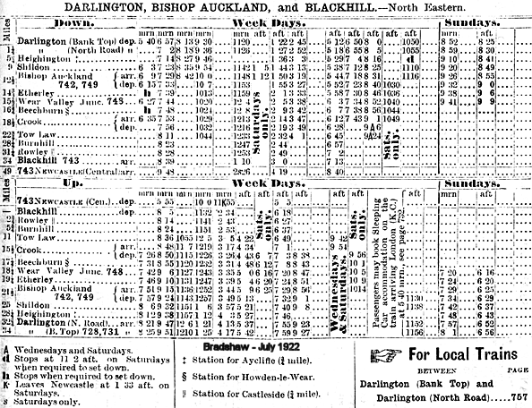
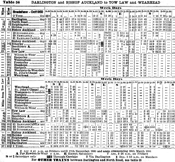
In the early years, the goods yard was very busy. There was considerable traffic in Ganister (fine-grained sandstone used in the manufacture of silica brick, typically used to line furnaces) between Rowley and Tow Law. There was also a healthy trade in livestock to and from the town’s cattle market which opened in 1882 adjacent to the goods yard on the north side of the level crossing. In 1898 the yard handled 9,532 head of livestock, exceeding that of other station on the line. In that year the yard also handled 15,396 tons of general goods, considerably less than the 110,968 tons handled at Crook. In 1890 the station carried 41,223 passengers bringing in an income of £2,967. In that year the parcels traffic brought receipts of £487 with livestock bringing in a healthy £10,468. In 1897 the station forwarded 3,760 tons of goods with receipts of £1,732 and received 14,468 tons. In 1900 the station carried 41,991 passengers bringing an income of £2,707.
 The passenger service between Tow Law and Blackhill was withdrawn on 1 May 1939. This northern section of the line had never handled much passenger traffic. In 1931 the two stations at Burnhill and Rowley carried only 4,982 and 2,548 passengers compared to 20,720 at Tow Law (less than half the number on 1900). The line was closed completely from a point two miles north of the station, with Tow Law becoming a terminus for trains from Darlington. This was, however, to be short-lived as passenger numbers declined rapidly after the war. In 1951 there were five weekday trains between Tow Law and Crook with an additional train on Saturdays and no Sunday service. As the Tow Law service was by now so unprofitable it was cut back to Crook on 11 June 1956. The passenger service between Tow Law and Blackhill was withdrawn on 1 May 1939. This northern section of the line had never handled much passenger traffic. In 1931 the two stations at Burnhill and Rowley carried only 4,982 and 2,548 passengers compared to 20,720 at Tow Law (less than half the number on 1900). The line was closed completely from a point two miles north of the station, with Tow Law becoming a terminus for trains from Darlington. This was, however, to be short-lived as passenger numbers declined rapidly after the war. In 1951 there were five weekday trains between Tow Law and Crook with an additional train on Saturdays and no Sunday service. As the Tow Law service was by now so unprofitable it was cut back to Crook on 11 June 1956.
 Goods traffic continued, but with the closure of a number of local collieries in 1960 traffic dwindled and the Sunnyside branch was closed and lifted. Inkerman Colliery north of Tow Law, remained in production and was now the only reason for retaining the line. The yard at Tow Law remained open during this period but handled little traffic. Blair's Steel Works at Tow Law was another source of revenue for the line. When the Bishops Auckland to Crook passenger service was withdrawn on 5 July 1965 the whole line north of Wear Valley Junction was closed with Tow Law yard closing on that date. The track was lifted in 1966/7. Inkerman Colliery outlived the railway line that served it; when it closed in 1969 it was the last deep mine in the town. It found notoriety during the 2001 foot and mouth crisis when MAFF buried diseased animals at the former pit. Goods traffic continued, but with the closure of a number of local collieries in 1960 traffic dwindled and the Sunnyside branch was closed and lifted. Inkerman Colliery north of Tow Law, remained in production and was now the only reason for retaining the line. The yard at Tow Law remained open during this period but handled little traffic. Blair's Steel Works at Tow Law was another source of revenue for the line. When the Bishops Auckland to Crook passenger service was withdrawn on 5 July 1965 the whole line north of Wear Valley Junction was closed with Tow Law yard closing on that date. The track was lifted in 1966/7. Inkerman Colliery outlived the railway line that served it; when it closed in 1969 it was the last deep mine in the town. It found notoriety during the 2001 foot and mouth crisis when MAFF buried diseased animals at the former pit.
Tow Law station remained intact for a few years, but by 1973 the site had been completely cleared prior to the construction of the Alpine Way housing estate.
BRIEF HISTORY OF THE BISHOP
AUCKLAND TO BLACKHILL LINE
The western section of the Stockton and Darlington Railway had been progressively improved and extended with the Bishop Auckland & Weardale Railway finally reaching Crook in 1843. The BA&W company minutes show that the line opened to a permanent station at Bishop Auckland on 30 January 1843, ahead of the rest of the line to Crook and that the generally quoted 8 November 1843 for opening to Crook was for goods only. The line was leased by the Stockton & Darlington Railway.
 The following stations were proposed: South Church, Bishop Auckland, Escombe, Old Etherley Colliery, Low Bitchburn, Howden and Crook. The line opened to a temporary terminus at South Church on 19 April 1842 and extended to a permanent Bishop Auckland station on 30 January 1843. The line to Crook was authorised for opening on 3 January 1844 but the passenger opening date to has not so far been traced; however, the minutes do show that the line was inspected on 1 January 1844 and that permission to open for passengers was received by, on or before 6 January. Escombe and Low Bitchburn stations are never mentioned again and were probably never built. The following stations were proposed: South Church, Bishop Auckland, Escombe, Old Etherley Colliery, Low Bitchburn, Howden and Crook. The line opened to a temporary terminus at South Church on 19 April 1842 and extended to a permanent Bishop Auckland station on 30 January 1843. The line to Crook was authorised for opening on 3 January 1844 but the passenger opening date to has not so far been traced; however, the minutes do show that the line was inspected on 1 January 1844 and that permission to open for passengers was received by, on or before 6 January. Escombe and Low Bitchburn stations are never mentioned again and were probably never built.
It is likely that the initial service to Crook was market days only because, when it first appeared in Bradshaw in July 1844, only a Thursday market service was shown but the line was in full use by January 1845.
The Derwent Iron Company was looking for an outlet to the south and itself considered building a line towards Crook and the Stockton & Darlington Railway but in the end it was the S&D who constructed the Weardale Extension Railway from Crook, via the rope-worked Sunniside (or Sunnyside) incline to a station at Tow Law joining the former Derwent Railway at Waskerley, at the head of Nanny Mayor’s Incline where a small railway village developed on the top of the moors. The line was opened to traffic on behalf of Derwent Iron Company on the 16 May 1845; the company subsequently purchased the Derwent Railway.
 Tow Law first appears in timetables in September 1847; references have been found to additional stops at High Souk (alias High Stoop) and Saltersgate Cottage, which would have been further north towards Burnhill. Although both stations appear on the early Ordnance Survey maps, passenger use cannot be confirmed. Tow Law first appears in timetables in September 1847; references have been found to additional stops at High Souk (alias High Stoop) and Saltersgate Cottage, which would have been further north towards Burnhill. Although both stations appear on the early Ordnance Survey maps, passenger use cannot be confirmed.
The Bishop Auckland & Weardale Railway amalgamated with the Wear Valley Railway in 1847 which was, in turn, taken over by the Stockton & Darlington in 1858 and by the North Eastern Railway in 1863. On 2 March 1868 the Sunniside incline was replaced with a deviation to allow locomotive haulage, which required the re-siting of Tow Law station.
In NER days a through service was provided from Darlington to Tyneside via Bishop Auckland, Crook, Tow Law, Burnhill and along the Derwent Valley Line through Blackhill and Swalwell. With increasing competition from roads and the decline in the handling of lime and stone the line north of Tow Law to Blackhill (Consett) was closed to passengers on 1 May 1939 along with the stations at Burnhill and Rowley, ending through running to Tyneside. Shortly after closure the government built the Salters Gate Ammunition Depot across the line between Salters Gate and Burnhill which effectively totally closed the through line, although munitions trains could access the Burnhill Station transfer yard from both directions.
 The line was further cut back to Crook on 11 June 1956 and the final section of line from Bishop Auckland - Crook closed to passengers on 8 March 1965. The track north of Wear Valley Junction was lifted in late 1967 or early 1968. The line between Bishop Auckland and Crook served a number of collieries and other industrial sites Click here
for a full list. The line was further cut back to Crook on 11 June 1956 and the final section of line from Bishop Auckland - Crook closed to passengers on 8 March 1965. The track north of Wear Valley Junction was lifted in late 1967 or early 1968. The line between Bishop Auckland and Crook served a number of collieries and other industrial sites Click here
for a full list.
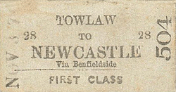
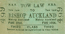
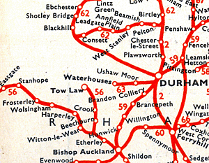
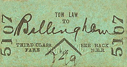
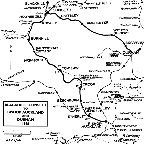
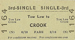
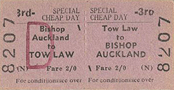
Tickets from Michael Stewart. Route map drawn by Alan Young. Bradshaws from Nick Catford. BR(NE) winter 1948 timetable map from Alan Young.
Sources:
To see the
other stations on the Bishop Auckland - Rowley line click
on the station name: Bishop
Auckland, Etherley,
Wear Valley
Junction, Beechburn,
Crook, Tow Law (1st site), High
Souk, Saltersgate
Cottage, Burnhill
Junction (Military Exchange Station), Burnhill
& Rowley
See also stations
on the Wear Valley line to Wearhead
|

law_old11.jpg)
old3.jpg)
law_old13.jpg)
weardale_railway_old2.jpg)
old8.jpg)
law_old20.jpg)
old4.jpg)
 Home
Page
Home
Page
law_old16.jpg)
