|
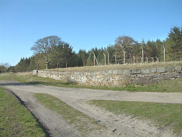
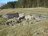
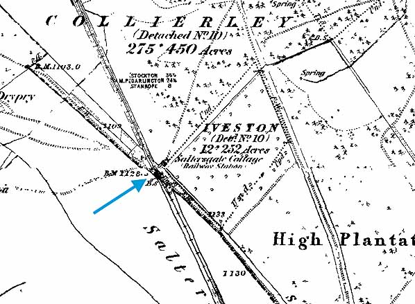
Notes: K. Hoole (author) lists the opening date for for mineral
traffic as 16.5.1845 and references have been found to a station
at Saltersgate Cottage which is clearly marked on Ordnance
Survey maps between 1855 - 1865 although there is no local
industry.
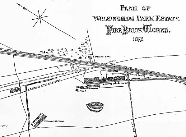
By 1894 the station is no longer shown although Saltersgate
Cottage itself is shown. There is also an old quarry, a disused
brickworks and a tramway running a short distance south, then
two miles east to a quarry.
Between 1919-1926 maps show Saltersgate Cottages, Saltersgate
Siding (stone wharf) and a tramway running west to an old
lead mine and a quarry.
It is possible that the passenger station was built and never
opened and that the site was then just used for transportation
of minerals using the stone wharf.
BRIEF HISTORY OF THE BISHOP
AUCKLAND TO ROWLEY LINE
The western section of the Stockton and Darlington Railway
had been progressively improved and extended with the Bishop
Auckland & Weardale Railway finally reaching Crook in
1843. The B A & W company minutes show that the line opened
to a permanent station at Bishop Auckland on 30 January 1843,
ahead of the rest of the line to Crook and that the generally
quoted 8 November 1843 for opening to Crook was for goods
only. The line was leased by the Stockton & Darlington
Railway.
The following stations were proposed: South Church, Bishop
Auckland, Escombe, Old Etherley Colliery, Low Bitchburn, Howden
and Crook. The line opened to a temporary terminus at South
Church on 19.4.1842 and extended to a permanent Bishop Auckland
station on 30.1.1843. The line to Crook was authorised for
opening on 3rd January 1844 but the passenger opening date
to has not so far been traced; however, the minutes do show
that the line was inspected on 1 January 1844 and that permission
to open for passengers was received by on or before 6 January
Escombe and Low Bitchburn stations are never mentioned again
and were probably never built.
It is likely that the initial service to Crook was market
days only because when it first appeared in Bradshaw in July
1844, only a Thursday market service was shown but the line
was in full use by January 1845.
The Derwent Iron Company was looking for an outlet to the
south and itself considered building a line towards Crook
and the Stockton and Darlington Railway but in the end it
was the S&D who constructed the Weardale Extension Railway
from Crook, via the rope worked Sunniside incline to a station
at Tow Law joining the former Derwent Railway at Waskerley,
at the head of Nanny Mayors Incline where a small railway
village developed on the top of the moors. The line was opened
to traffic on behalf of Derwent Iron Company on the 16 May
1845; the company subsequently purchased the Derwent Railway.
Tow Law first appears in timetables in September 1847; references
have been found to additional stops at High Souk (alias High
Stoop) and Saltersgate Cottage, which would have been further
north towards Burnhill. Although both stations appears on
the early Ordnance Survey maps, passenger use cannot be confirmed.
The Bishop Auckland & Weardale Railway amalgamated with
the Wear Valley Railway in 1847 which was in turn taken over
by the Stockton & Darlington in 1858 and by the North
Eastern Railway in 1863. On 2nd March 1868 the Sunniside incline
was replaced by a deviation to allow locomotive haulage, this
required the resiting of Tow Law station.
In NER days a through service was provided from Darlington
to Tyneside via Bishop Auckland, Crook, Tow Law, Burnhill
and along the Derwent Valley Line through Blackhill &
Swalwell. With increasing competition from roads and the decline
in the handling of lime and stone the line north of Tow Law
to Blackhill (Consett) was closed to passengers in May 1939
along with the stations at Burnhill and Rowley ending through
running to Tyneside. Shortly after closure the Government
built the Salters Gate Ammunition Depot across the line between
Salters Gate and Burnhill which effectively totally closed
the through line although munitions trains could access the
Burnhill Station transfer yard from both directions.
The line was further cut back to Crook on 11th June 1956
and the final section of line from Bishop Auckland - Crook
closed to passengers on 8th March 1965. The track north of
Wear Valley Junction was lifted in late 1967 or early 1968.
The line between Bishop Auckland and Crook served a number
of collieries and other industrial sites. Click here
for a full list.
To see the
other stations on the Bishop Auckland - Rowley line click
on the station name: Bishop
Auckland, Etherley,
Wear Valley
Junction, Beechburn,
Crook, Tow
Law, High Souk,
Burnhill Junction (Military
Exchange Station), Burnhill
& Rowley
See also stations
on the Wear Valley line to Wearhead
|

 Home
Page
Home
Page
old1.jpg)