
Station Name: TOW LAW (2nd site)
law_old19.jpg) The main station building on the down platform c1954. The local sandstone building was designed for the NER by William Peachey, best known for his imposing station at Middlesbrough. It comprises a two-storey stationmaster's house (left) and the single-storey station offices (right). Each has a gable end facing onto the platform; these are linked by a verandah with a sloping roof, supported at the front by four cast iron columns. The main station building on the down platform c1954. The local sandstone building was designed for the NER by William Peachey, best known for his imposing station at Middlesbrough. It comprises a two-storey stationmaster's house (left) and the single-storey station offices (right). Each has a gable end facing onto the platform; these are linked by a verandah with a sloping roof, supported at the front by four cast iron columns.Photo from Alan Brown collection old1.jpg)
Tow Law station looking north west along the up platform in 1954; A5/2 69833 is regularly seen on the line having been allocated to 51A Darlington shed since 1948. The station garden, seen on the left, still appears to be well tended. The NER signal box seen at the end of the up platform is typical of boxes in the Darlington area - click here to see
the same view today.
Photo from John Mann collection law_old18.jpg) Looking south-east towards Tow Law station in 1962. The station had closed to passengers on 11 June 1965 but the goods yard (behind the photographer) remained open until 5 July 1965. A number of signal boxes in the NER's Stockton & Darlington (or Central) Division built between the 1870s and 1890s had these distinctive decorative supporting braces between the bargeboards which makes them instantly recognisable. A surviving example (although closed since 1987) can be seen at Cargo Fleet
Road near Middlesbrough. Photo received from Edna Pentecost old7.jpg)
Stephenson Locomotive Society (Teesside Branch) 'South Durham Limited' brake van railtour is seen at Tow Law station on 25 May 1964. The engine ran tender-first to Forcett, Valley Junction where it ran round to enable it to tackle the stiff climb to Tow Law boiler-first. At Tow Law the engine ran round again and, after traversing the Spennymoor line, the engine then propelled the vans
to Coxhoe West Hetton. old5.jpg)
Tow Law station looking north-west along the up platform in 1964, eight years after closure to passenger traffic. This might be the same day as the railtour shown above. Although the station looks derelict the station offices were still in use at this time as the goods yard did not close until 1965. The verandah has been removed although its position is clearly visible. There is a rectangular ‘General Waiting Room’ sign above the door in the far wing of the building.
Photo from John Mann collection old21.jpg)
Another view of the Stephenson Locomotive Society (Teesside Branch) 'South Durham Limited' brake van railtour is seen at Tow Law station on 25 May 1964.
Photo by Alan Brown old22.jpg) Having run round its brake vans 4F 43129 is ready for the next leg of the 'South Durham Limited' tour to Ferryhill via Crook, Wear Valley Junction, Etherley, Bishop Auckland, Coundon and Spennymoor. This Ivatt designed 2-6-0 was built in October 1951 at Horwich works. It lasted in service only 16 years and was withdrawn from 20D Normanton shed on 31 July 1967 and cut up at Cohens of Kettering four months later.
Photo by Alan Brown law7.jpg)
The photographer is standing on the trackbed of Weardale Extension Railway from Crook to Tow Law looking north-west in April 2006. Church Lane is seen on the right. The site of Tow Law station was on the left where the houses are. Tow Law coal depot is straight ahead, between the houses
and Church Road. Photo by Richard Ashby 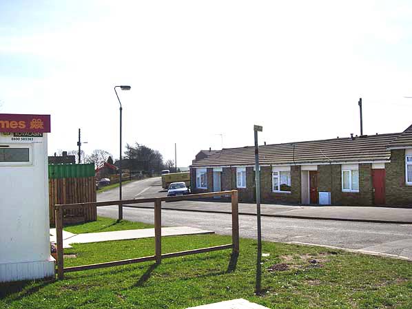 The photographer is standing with his back to the High Street level crossing; the original Tow Law station was on the west side of the crossing. Church Road is seen straight ahead; it originally ran straight to a junction with High Street out of view to the left. In the 1970 it was realigned to the south to make a new junction with High Street. The original line to Crook ran parallel with Church Road, and the 1868 deviation curved round to the south and into the new station just beyond the houses seen here. The houses are on the site oil Tow Law goods shed.
Photo by Richard Ashby law8.jpg)
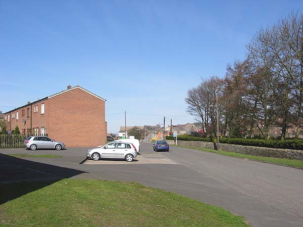
Looking north-west at the site of Tow Law station seen from Station Road in 2010. The photographer is standing on the trackbed with one platform either side in front of him.
Photo
by Dean Morris
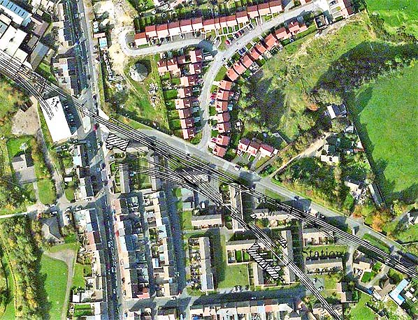
The track layout at Tow Law superimposed onto a modern aerial photograph. Church Road runs diagonally across the picture, with the original S&D alignment running parallel to Church Road and the deviation curving to the south through the new station. High Street runs north to south along the left side. The building to the right of High Street is the goods shed. Station Road runs from High Street along the bottom of the picture.
Click on thumbnail to enlarge
 Home
Page Home
Page
|
old23.jpg)
law_old_thumb10.jpg)
law_old_thumb12.jpg)
