
Station Name: LEWISHAM (1st site)[Source: Nick Catford]
old0.jpg) Lewisham's first station had a short trainshed covering the two platforms. The entrance and booking office was below the bridge with steps up to the two platforms. Most of the windows shown in this engraving appear to be false with only one on the upper floor and one on the lower floor (the booking office) having glass. The scene is very rural compared to a view from the same position today. Lewisham's first station had a short trainshed covering the two platforms. The entrance and booking office was below the bridge with steps up to the two platforms. Most of the windows shown in this engraving appear to be false with only one on the upper floor and one on the lower floor (the booking office) having glass. The scene is very rural compared to a view from the same position today.
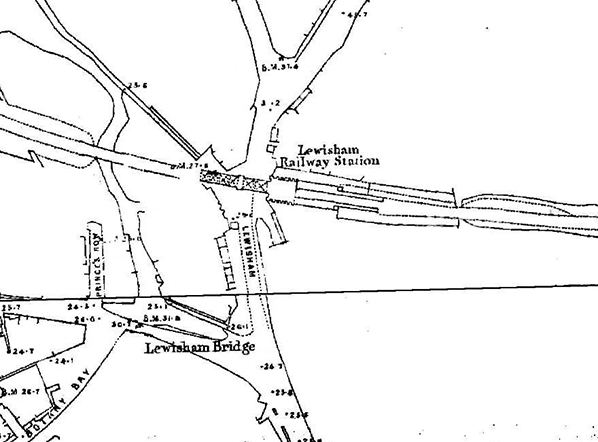
1850 1:2,500 OS map. The first Lewisham station is clearly shown on this 1:2,500 OS map with two facing platforms and an overall (trainshed) roof at the west end.
1890 1:2,500 OS map. Although closed for over 40 years the original station is still shown on the 1897 1:2,500 OS map. Two shaded areas are seen at the west end of the station. This usually indicates canopies but might just be a covering over the exposed open stairways up from the booking office below. There is a siding running up to the east end of the down platform. Note the horse tramway is double track either side of the Lewisham Road bridge but is only single track where it runs under the bridge.. Click here for a larger version.
old1.jpg) The shop of John Fells, spirits and wine merchants beneath the railway bridge at Lewisham. occupying the entrance of Lewisham's original station c1890s, there being another doorway to the immediate south of the bridge in open air. Fells were incorporated in 1858, the station having reportedly closed in 1857. The company imported via the London Docks and had offices and a bottling facility at 58 Tooley Street, beneath the railway arches. Click here for a colourised version of this photo.
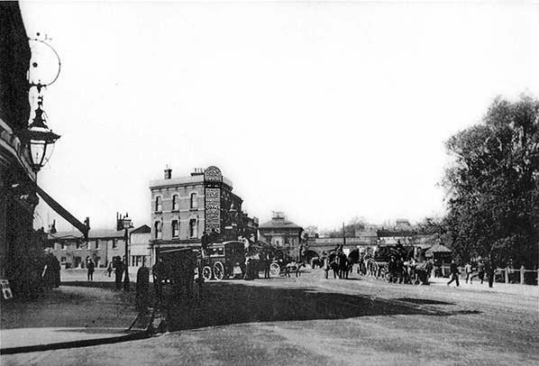
Looking north along Lewisham High Street in the first decade of 20th century. Loampit Vale is to the left with the High Street straight ahead. The bridge charring the North Kent line over Lewisham Road is clearly seen in the distance. The River Quaggy runs to the right of the road. Horse trams run along Loampit Vale and Lewisham High Street. The tall building is the Duke of Cambridge pub at 32 Lewisham High Street (now demolished). The pub opened in 1858, the year after the second Lewisham station.
old3.jpg)
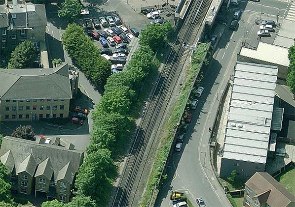
Aerial view of Lewisham in 1925. The 1857 Lewisham Junction station is seen bottom right. Top left the bridge over Lewisham Road is seen and to the north of the line the widened viaduct where the platforms for the first Lewisham station were located. It is difficult to make out if the platforms are still there although is does appear that the down (left) platform is still in place. We know from photographic evidence that there was an entrance to the station on the south side of the bridge. From this photograph there doesn't appear to be an entrance on the north side but there may be a window. Click here to see larger version.
old4.jpg)
The shop continued to trade from the old booking office until some time during WW2. Some alterations to the windows have taken place since the earlier view. The shop address can be seen as 1A High Street and presumably 1 High Street was the address of the railway station. Note the telephone number 1138 Lee Green. This dates photograph to no earlier than 1909, the year Lee Green telephone exchange opened under the auspices of the National Telephone Company which shortly afterwards was incorporated into the GPO (General Post Office). The format of the telephone number, 38, Lee Green, was in common usage at the time and originated with the National company. It took some years for the format to reverse, ie exchange name preceding the number, following the emergence of the GPO. John Fells, or John E. Fells to use the precise name, are still trading today but are now based in Hertfordshire and all traces of the shop at 1A High Street have long since disappeared. old5.jpg) In this 1939 aerial view the 1857 Lewisham Junction station is seen top left with the original station on the right. The down platform might be seen on the north side of the line, Click here to see a larger version.
Photo from Britain From Above, reproduced with permission 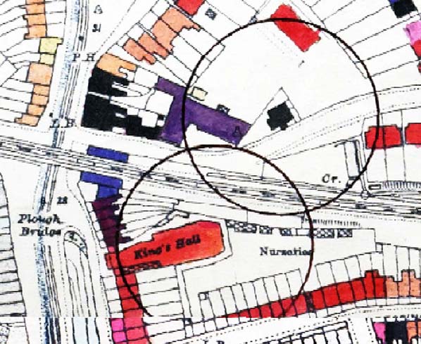
A section of map produced by the London County Council showing V1 flying bomb strikes. The one to the north of the line is a shows the V1 strike on Granville Park on 26 June 1944. that to the south of the line show the V1 strike on the Kings Hall cinema in Lewisham High Street on 3 July 1944. The accuracy of this position is in doubt. The aerial photo below shows the damage to the cinema is minimal and in fact the building was repaired and remained in use as a cinema until 1986. Some sources say the V1 hit Cressingham Road to the south. It is unclear if either of these bombs led to the closure of Fells shop in the former station booking office. This map is based on the 1897 OS map and it is unclear why the west end of the platforms and part of the adjacent building have been coloured blue. The colour codes for the LCC bomb damage maps can be seen here. Buildings that have been totally destroyed are coloured black and those damaged beyond repair purple. Blue doesn't appear in the key but as the station is between two black area it is assumed that it too has been damaged beyond repair. Blue may indicate buildings that have already been cleared by the time the map was prepared. It would have been necessary to repair the bridge quickly to allow trains to run again.
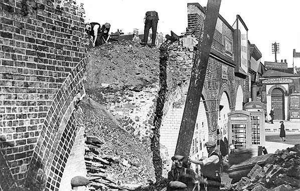
Taken some time during WW2 this photo shows high explosive bomb damage to the railway bridge being repaired. This is not the damage caused by the V1 strike in 1944, this was far more extensive. John Fells shop on the far side of the road appears to be still trading at this time. Note another station entrance on the east side of the bridge. The main entrance into the booking office would have been under the bridge; this may have been an exit at the bottom of the stairs from the up platform. Note part of the original building (coloured blue on the LCC map) behind the door. Photo
from Lewisham Library. old6.jpg)
Postwar aerial view showing cleared bomb damage and the repaired railway bridge. All the buildings coloured black and purple on the LCC map have now been cleared away. The railway bridge has been repaired or partially replaced on the east side of the road. The station entrance (John Fells shop) has now gone. Parts of the platforms might still remain at this time. Click here to see a larger version Photo from Imperial War Museum, reproduced under creative commons licence 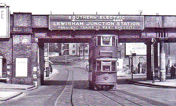 This view facing north is undated but is postwar and no later than 6 October 1951 when the 58 tram ceased to operate. Granville Park goes off to the right while in the background Lewisham Road bears left and Lewisham Hill, largely hidden by the tram, bears off the right. The Lacey House flats, built upon the site of what had been terraced houses, can be seen in the background. The entrance to Lewisham's original station and what became John Fells' shop had stood where the bridge supporting columns are. The 'H' and arrow painted on the nearest column indicated the presence of a nearby fire hydrant. The 'No Rinsing' advertisement is most likely for 'Tide' laundry detergent, a product which first appeared, initially in the USA, in 1946. The advertisement overlooks what is clearly evidence of wartime bomb damage. It is not known if this was HE bomb or V1 Flying Bomb damage but may well be the same attack which saw the end of the entrance to the original station. On the bridge, the 'Southern Electric' branding was a common sight in South London and elsewhere on the former Southern Railway, with examples surviving well into British Railways days. The tram is HR2 class No.149. The 58 route ran between Blackwall Tunnel and Victoria Station to which destination car 149 is operating. The route was via South Street (Greenwich), Lewisham Road and High Street, Rushey Green, Catford, Forest Hill thence via the famous, in the tram context, Dog Kennel Hill (Dulwich), Camberwell Green, Kennington and Vauxhall Bridge. The tram has just escaped the single track with passing loops section along Lewisham Road and has now reached the relative freedom of double track. The entire 58 route used the conduit current collection system.
Copyiight photo from Stations UK 1.jpg)
Looking east from the up platform of the second Lewisham station at the site of the first station. There is now an overlap between the first and second station. When the second station was opened its platforms were considerably shorter so there was no overlap. now they extend over the
Lewisham Road bridge. Photo
by Nigel Thompson. Reproduced from Geograph under creative commons licence
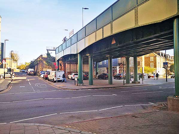
Looking east at the site of the first Lewisham station in April 2021. The original entrance, and Fells shop, was on the east side of the road. The new bridge overlaps the original station by some distance. The widened viaduct, where the platforms were located, now starts some distance along Granville Park. As can be seen here by the platform lights and signs, the present Lewisham station extends to the east end of the bridge. The platforms were extended over the bridge in 1954 to accommodate 10-car units.
Photo by Nick Catford 3.jpg)
The original viaduct in Granville Park in April 2021. The difference between the new bridge and the viaduct indicates the width of the platforms. The Premier Inn now stands on the site of the Kings Hall cinema.
Photo by Bill Kelsey 4.jpg)
Looking west along Granville Park in April 2021. The viaduct seen here once supported the first Lewisham station’s down platform.
Photo by Bill Kelsey 5.jpg)
|

 Home Page