
Station Name: DOVER PRINCE OF WALES PIER[Source:Nick
Catford]
See also: Folkestone (temporary station), Folkestone East, Folkestone Harbour, Folkestone Warren Halt, Shakespeare Cliff Halt, Archcliff Junction Staff Halt, Dover Town, Dover Admiralty Pier, Dover Marine/Western Docks pier_old6.jpg)
The Prince of Wales Pier in 1902, possibly before opening as there is no toll kiosk at the pier entrance. The ramp up to the pier alongside the Granville clock tower is built of stone. As the pier goes over water the pier is built on a framework of cast iron trestles on screw piles with lattice girders similar to many other Victorian seaside piers of the time including the nearby Promenade pier. It was planned that the recesses on either side of the first section of the pier would be covered to provide protection from the weather. It would appear from this view that only the middle pair were covered.
 Map showing the proposed improvements to Dover Harbour. The pier was known as the East Pier at this time. From 'The Times' 10 October 1892. Click here for a larger version. 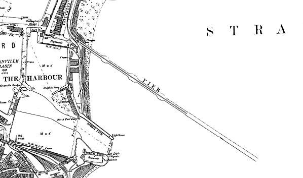 1898 1:2,500 OS map shows the pier under construction. Although named 'Prince of Wales Pier' in 1893 it is just identified here as 'Pier'. The 'Granville clock tower' has not yet been moved and is seen here in line with the entrance to the pier. The ‘Esplanade’ Hotel is also blocking the route of the future railway line. The three bays either side are covered areas to provide protection from the weather for members of the public using the pier. Click here for a larger version. 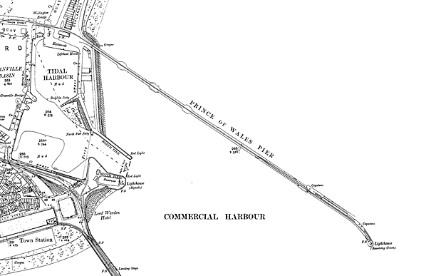 1907 1:2,500 OS map shows the completed pier, now named 'Prince of Wales Pier’. The 'Granville clock tower' has now been moved to allow a single-track railway line to be laid along the pier. The centre section of the ‘Esplanade’ Hotel has also been demolished to allow the line through. This line crosses Wellington swing bridge over the entrance lock to Wellington Dock before running onto the pier. Landing stages are seen on both sides at the end of the pier; also shown is the passenger platform alongside the eastern berths. There is a passing loop just before the landing stages are reached. At the bottom of the map, the north end of the Admiralty pier is shown with the former SER line curving round to the left past Dover Town station and the former LC&DR line passing to the east of the ‘Lord Warden’ Hotel and running into Dover Harbour station. Click here for a larger version.
Click here for a larger version. 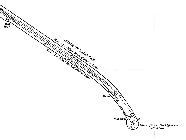
1957 1:2,500 OS map showing the seaward end of Prince of Wales Pier. All evidence of the landing stages and the passenger platform has gone as has the single-storey building near the lighthouse. A café is shown, built against the lighthouse with public toilets alongside.
pier_old34.jpg)
pier_old14.jpg)
and Wellington Dock. Copyright photo from John Alsop collection pier_old12.jpg) Looking south-east along the Prince of Wales pier from the Esplanade Hotel c1904, shortly after the railway track was laid along the pier. The building on the right is Dover's first lifeboat station which was built in 1866 by the Royal National Lifeboat Institution, which had taken over the lifeboat service from the Dover Humane and Shipwreck Institution in 1855. The building was modified in the late 1870s to accommodate a bigger lifeboat. The clock tower was built in 1876-7 to the designs of George Devey. The work was commissioned by the Dover Harbour Board. The tower was moved a short distance as it stood on the approach road to the pier. Both buildings are now Grade II listed. The entrance to the pier is protected by ornate gates; a kiosk for collecting tolls is seen on the right. In the distance the tall tower on the Admiralty Pier is a temporary lighthouse built c1900 as the pier was being extended. It was relocated (or replaced with a new lighthouse) at the new pierhead in 1908. The somewhat shorter lighthouse at the end of the Prince of Wales Pier is seen to its left.
Copyright photo from John Alsop collection pier_old13.jpg)
By the end of 1904 boat trains were a regular sight crossing the Wellington swing bridge and proceeding on to the ocean liner berth at the end of the Prince of Wales Pier.
Copyright photo from John Alsop collection
pier_old21.jpg)
Looking seaward from the Prince of Wales Pier c1904. The arrival of the German Hamburg-Amerika line was a great boost to Dover. Their 'Graf Waldersee' liner is seen on the east side with the Thames excursion paddle steamer the ‘Koh-I-Noor’ at one of the inner harbour berths. The ‘Koh-I-Noor’ called there about four times a week between 3pm and 4pm once the Prince of Wales Pier was opened in 1903 and continued to do so till 1914 on a route that ran Tilbury-Southend-Margate-Ramsgate-Deal-Dover and back to Tilbury. ‘Koh-I-Noor’ was due to have new boilers fitted just before the outbreak of WW1, but in the event this did not happen and after sailing back to her builders for the work to be done, she was laid up for the duration and never again entered service, being cut up at
Morecambe in 1919. Photo from John Mann collection pier_old22.jpg)
Looking out to sea from Dover beach on a hot summer day c1904. This view shows the exposed east side of the pier before the construction of the Southern Breakwater to complete the Admiralty Harbour. The 4212ft long breakwater was built between 1907 and 1909.
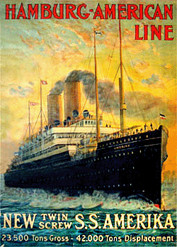
pier_old5.jpg) SS ‘Deutschland’ is seen at the Prince of Wales Pier in 1905. She was owned by the German Hamburg-America Line and was launched in January 1900 at Hamburg; sailing for over 25 years under three different names. She was the second ship to have been built as a four-stacker. In the early years, the Hamburg-Amerika Line exclusively connected European ports with North American ports, such as Hoboken, New Jersey, or New Orleans. In 1910, Hamburg-Amerika withdrew ‘Deutschland’ from transatlantic service and converted her to a dedicated cruise ship renamed ‘Viktoria Luise’ - one of the first liners of the twentieth century to operate as such. In 1906, the ‘Deutschland’ crashed into the Prince of Wales Pier and required 40 new bow plates; the service was switched to
Southampton soon afterwards. Photo from Jim Lake collection
 Home
Page Home
Page
|
 An article in the Illustrated London News of 22 July 1893, titled 'The new Harbour works at Dover', describes the proposals: ‘The scheme of the Dover Harbour Board, for the accommodation of commercial shipping east of the Admiralty Pier, is being carried into execution by Messrs. Coode, Son, and Matthews, engineers, successors to the late Sir John Coode, by whom the works were designed. There will be a new pier, starting from an open iron viaduct 1260ft long, forming an agreeable marine promenade, which will be approached from the esplanade near the Granville clock tower. This involves the removal and rebuilding of the clock tower. The solid pier, at the end of the iron viaduct, will be of concrete blocks faced with granite, equal in height to the Admiralty Pier, and 1500ft in length; its direction at first will be south-easterly, but its outer portion will curve to the south-south-west, approaching the end of the Admiralty Pier, to which an extension of 580ft will be added.’
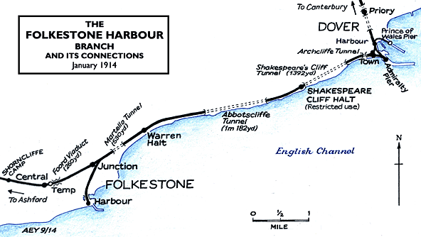
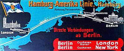 For a brief period between 1905 and 1906 German liners of the Norddeutsche Lloyd and the Hamburg-Amerika line would call at Dover on their way to New York. From 1881 until 1914 the Hamburg-Amerika Line was the world's largest shipping line. It transported hundreds of thousands of emigrants from Germany, Scandinavia, and eastern Europe to the United States, Canada, Latin America, and other destinations around the world. Their first liner to call at Dover was the 'Prinz Waldemar' in July 1904. Unfortunately, as the outer harbour was nearing completion, and the gap between the Southern Breakwater and the Admiralty Pier was narrowing, the currents through the newly formed western entrance made handling these large vessels difficult, especially in bad weather. On one occasion, the Hamburg-Amerika line's 'Deutschland' crashed into the pier. The Hamburg-Amerika Line moved its operations to Southampton in 1906 with the other liner companies following suit over the next two years.
 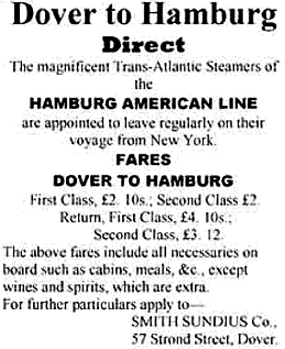 With the outbreak of war in 1914 all passenger services ceased to operate and the pier taken over for military use including a 6in rail-mounted gun for use against German airships. After the war, the ferries and liners never returned to the Prince of Wales Pier with a regular service although some liners did berth there in the 1930s. In later years, the Harbour Board tugs, Lady Brassey and Lady Duncannon were berthed alongside on the western side of the pier. Dover Harbour was particularly important in the Dunkirk evacuation when 200,000 men were returned from Dunkirk to Dover in eight days. During this period the Prince of Wales Pier was one of many places used for disembarking returning troops.
 In 1993 a ‘Seacat’ catamaran berth was built alongside the pier as part of the Hoverport complex. In 1994 the Channel Tunnel opened and, even though the Hovercraft was still the fastest way to cross from Kent to France, its days were numbered. In 2000 Hoverspeed decided to end hovercraft operation. The abolition of duty-free sales in June 1999 had resulted in a significant drop in passenger numbers. On 1 October 2000 the last Hovercraft was brought up onto the beach outside the former ‘Churchill’ Hotel in Dover at the spot where the first hovercraft had landed in 1959. Seacats took over the service the following day. Rising fuel costs, the loss of duty free, a declining market and fierce competition finally put paid to Hoverspeed who announced after much speculation that they would cease operations entirely on 7 November 2005. The Hoverport buildings on the reclaimed land adjacent to the pier were demolished during the summer of 2009.