
Station Name: YARMOUTH SOUTH TOWN
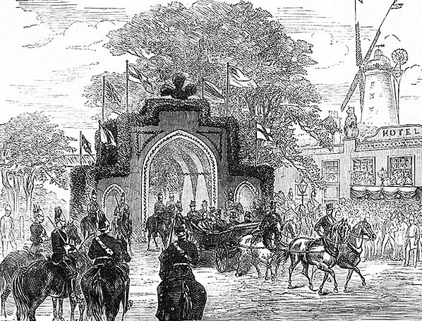 The arrival of the Prince of Wales, later to become King Edward VII, at Yarmouth South Town in June 1872. The Prince is known to have been in Yarmouth on 6 June that year, attending a number of functions, so this engraving probably represents the scene on 5 June. The primary purpose of the visit appears to have been concerned with the Norfolk Artillery, who had a detachment in Yarmouth. The Norfolk Artillery was a volunteer regiment and eventually became part of the TA before being disbanded in 1955. The Prince stayed at Shadingfield Lodge a number of times during the late nineteenth century and did so in 1872. Shadingfield Lodge was built in 1865 as a summer villa and eventually became a public house. Located on Marine Parade, South Beach, it became a casino in 2000. The so-called Triumphal Arch was probably a wooden structure draped, as seen here, in various garnishings assuming, that is, it actually existed as these engravings were prone to varying degrees of artistic licence. On the right a representation of the Two Bears hotel can be seen. One of the two bear statues can be seen and this proves something of a problem as local media, reporting on the demolition of the building during 2013/14 period, stated the bears, perched up on the roof, dated from 1910. As the artist could not have foreseen the appearance and position of the bears, unless time machines existed in 1872, they are therefore assumed to be much older. The building itself dated from 1865; rather this is the earliest record of it which has been discovered. Behind the hotel stands High Mill, said to have been the tallest brick-built mill in the country. When it was demolished its bricks were reused for the construction of some nearby terraced houses (see text).
From Illustrated London News  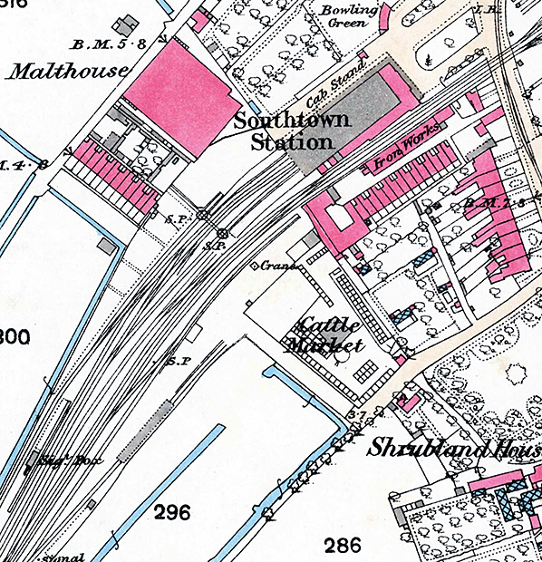
1887 1:2,500 OS Map. The platforms can be seen at the length they had been extended to (300ft to 450ft) in 1884 but there is still no Platforms 1 and 4 apart from a siding stub encroaching into what would become Platform 4 (the northernmost platform face). Of particular interest is the short siding near the Malthouse, entered via turntables with the track crossing the running line at a right angle. One of the turntables is situated on, of all things, the Up (departures) running line. Whilst this arrangement may surprise some readers, it was not uncommon in the nineteenth century although as locomotives grew larger and heavier the practice was soon abandoned. Therein lies the problem with reliance upon old maps; the turntables are not shown on the 1886 map yet are thought to have been present since at least 1869. Mentioned in the text is a Great Eastern Railway Minute from 23 September 1869 which mentions a turntable causing frequent coupling breakages. The turntable required relocating but the cost of £50 was refused at the time. The next reference, this time specifically for a locomotive turntable, was in February 1881 and the £400 cost of this was recommended. This was a 40ft turntable and there is no record of when it was actually installed. What we do know is that also in February 1881 £208 was approved for a new turntable balance, so it would appear provision of a new balance was abandoned very rapidly in favour of a completely new turntable. We are grateful for the survival of old maps, Company Minutes and other sundry documents but after the passing of well over a century these are all we have to go on. Therefore it is possible the two turntables shown on this map constituted the original locomotive turning facilities but the passage of time means confirmation has become impossible. A further point on interest is the crane: nothing unusual about that, except that it seems to have disappeared and reappeared at various times. Note the cattle market and, north of the station, the bowling green. Studying various maps and photographs shows that the cattle market moved further south-west and the bowling green also became a cattle market. The latter is curious as photographic evidence does not concur with cartographic evidence; the 1928 map, for example, shows the bowling green site as being a cattle market yet aerial photographs from roughly the same time show that it as still a bowling green.
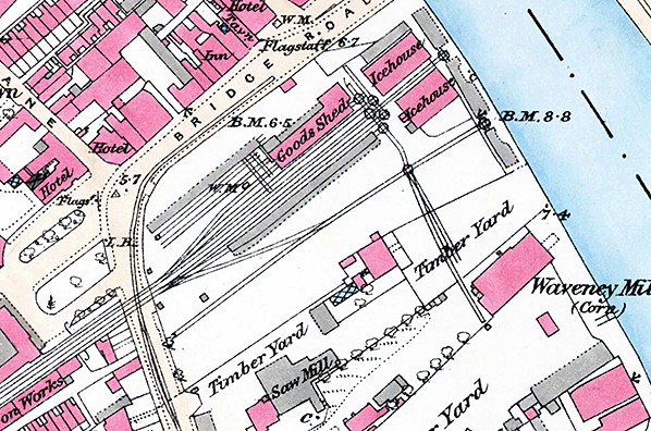
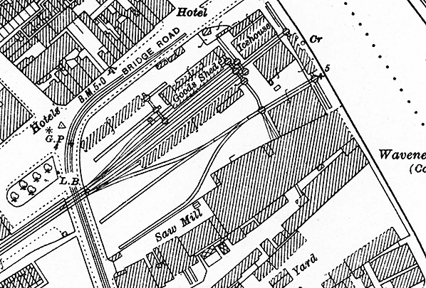
1887 1:2,500 OS Map shows two tracks leading along the south side of South Town station and crossing the road into the goods yard. Maps of this age are not necessarily accurate; in the goods yard not all wagon turntables are shown yet the tracks to which they gave access are. In addition, two icehouses are shown yet surviving railway company records mention only one - that closest to Bridge Road and this building still stands today. The two hotels shown near the top left were, left to right, the Two Bears and the Railway Hotel. The latter still stands as of 2017 and is now a pizza outlet. Note the weighing machine (W.M.) on Bridge Road. Presumably this was for vehicles, horse drawn of course, wishing to cross Haven (aka Southtown) Bridge as the road was a Turnpike at this time - a situation, mentioned in the text, which caused some consternation for the GER.
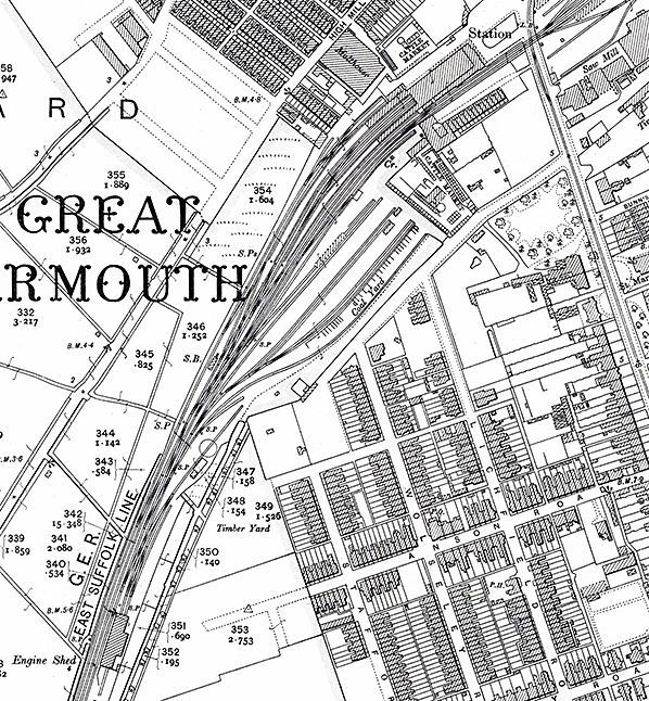 1906 1:2,500 OS map. By this date South Town station plus its goods and locomotive facilities have taken on the form which would remain familiar until 1952 - with a few minor exceptions. The station now has three platform roads, with Platform 1 (on the south-east side of the station) coming into use with the opening of the Lowestoft line shortly before. What became Platform 4 has been widened at its outer end and is in use as a short bay probably, at this date, for non-passenger use. The coal yard, which was not provided until as late as 1884, is shown but as yet no cattle dock or pens are shown, The provision of cattle pens, photographic evidence suggests, was something of a 'now you see it, now you don't' affair and in later years the coal yard took over more or less the entire sidings area. The cattle market south of the station would later occupy the near-vacant site at the end of Station Road (the unnamed road running parallel to the coal yard). The siding running behind the signal box had been a dead end; it now continues southwards towards Yarmouth South Town Junction (off the bottom of the map). The iron works which had stood between the station and what was then Plevna Road has now gone.
Click here for a larger version 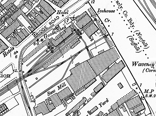
1906 1:2,500 OS map. This map shows the goods yard more or less in the form it was maintain for the rest if its life, especially insofar as the track layout is concerned. This map makes a good comparison with the fire insurance plans from around the same time and reproduced below. It should be remembered that the two tracks crossing Southtown Road were not Up and Down lines but two bidirectional sidings. Note that, compared to the 1887 map, only one icehouse is indicated yet both buildings are still present. Railway records mention only one icehouse so it is possible that there is an error on the 1887 map. The building not marked as an icehouse may have been a fish-packing shed and such a building is mentioned in Company records, albeit without giving its precise location. Note the Norfolk/Suffolk boundary midway of the river; South Town station was therefore in Suffolk at this time. The weighing machine on Bridge Road has disappeared, or at least is no longer marked.
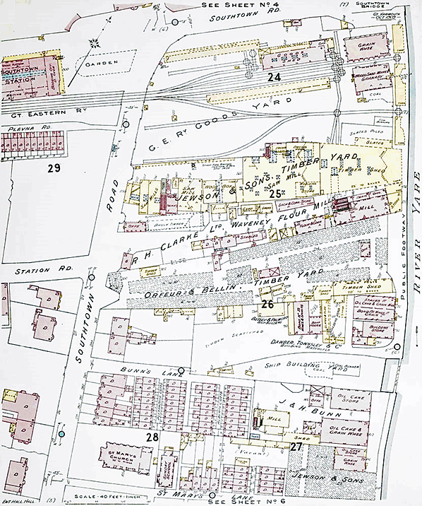
One of a series of 40ft to 1in plans produced by Charles E Goad in October 1909 for fire insurance purposes, in this case showing the area around South Town goods yard. Goad was a Canadian company which started out in 1875, opening a London office ten years later. Although not vastly different from any other map of the time certain labels, such as 'Slates Piled', 'Timber Scattered' and 'Vacant' represent the 'on the ground' situation at the time the survey was carried out and this is what differentiated insurance plans from standard maps. At top right, Haven Bridge is marked as 'Southtown Bridge' while notable by its absence is the electric tramway along Southtown Road. At top left, the station is spelled as one word and not as 'South Town' in the manner the railways always did. Clearly shown are the two tracks which passed along the south side of the station forecourt before crossing the road to enter the goods yard and, as mentioned in the text, these were the final lengths of track to remain in situ following closure. The awkwardness of the goods yard, being reliant upon numerous wagon turntables, is obvious. The yard saw several changes over the years and from surviving GER Records it appears the sidings disappearing into Jewson's timber shed began life as a single siding, whilst the aforementioned siding serving Jewson's loading stage was a later addition. Adjacent to the loading stage is marked 'Staff Fire Brigade', presumably a Jewson facility. South of the goods yard are numerous other industrial premises including a Ship Building Yard and another Jewson premises. These will have also used the GER goods yard but with cartage being used the short distance to and from but a good proportion of goods would have still been transported by water in 1909. Perhaps surprisingly, facilities for fish traffic appear to be absent, including the ice house (which was located adjacent to Haven Bridge). The reason for this was Yarmouth's fish traffic being mainly handled on the quays on the opposite side of the river which were served by the quayside tramway. There was, however, a smoking shed at some time and this did send out goods via South Town. At top left can be seen part of the passenger station. It shows the basic layout of the station building but is by no means well detailed. This is the only known surviving plan of the pre-1952 station building. British Railways’ plans from 1952
have, however, survived. Click here for a larger version. Plan reproduced by kind permission of The British Library. 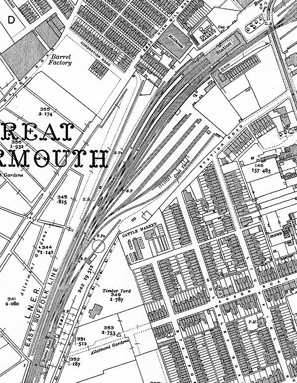
1928 1:2,500 OS map. Apart from some alterations to sidings and pointwork, little has changed on the railway scene since 1906. An additional siding has, however, appeared on the Down side and stretches to a point opposite the end of Coronation Road but its purpose is unknown. It may have been for the barrel factory although given the factory's distance from the railway the siding would have offered little advantage unless the barrel business was booming to the extent where special facilities were deemed necessary. Great Yarmouth once had a thriving brewing industry, little known outside the locality owing, no doubt, to being overshadowed by the fishing industry. One point to note Is that the cattle market south of the station has now moved to the end of Station Road, opposite the locomotive turntable which by this time was a 60ft example and would remain so until 1951/52 when the little-known 65ft example took its place. Click here for a larger version.
 1928 1:2,500 OS map. There have been some minor alterations to the track in the goods yard near the goods shed - this was the GER goods shed - but little else has changed since 1906. Two points to note elsewhere are the disappearance of the smaller garden on the station forecourt and which was also absent on the 1906 map, plus the tramway which is now shown as being double track and, indee,d had been for some years. In 1928 the Great Yarmouth Corporation trams on the Gorleston route, which was isolated from the rest of the system, had a mere couple more years to go before they were withdrawn.
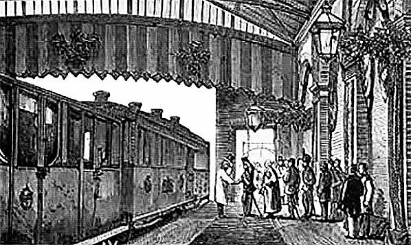 By no means the best quality image, this engraving shows the arrival of the Prince of Wales at South Town station in June 1872. The accuracy of the detail is an impossible to judge but we can take it as a reasonably accurate depiction of the interior of the station in its original form. The platform seen here would in due course become Platform 3. The roof seen here was destined to be removed by British Railways and the wall on the right largely demolished. The wall dead ahead, with the opening, was also removed on an unknown date - if, that is, it ever existed; it could be mere artistic licence to provide a backdrop for the Royal party. The carriages of the Royal Train should not be taken as accurate representations; that on the left, for example, looks like an odd mix of Queen Adelaide's saloon and that built for Queen Victoria in 1851. The latter is worth an additional mention as it came to be known as the 'Prince of Wales' carriage' and is thought to have ended up on the Kent & East Sussex Railway*. Notwithstanding this, the Prince of Wales is known to have requested the provision of ordinary saloon carriages in 1866 as he apparently did not like the 'florid' decoration of his mother's carriages. This did not stop the by then King Edward VII ordering his own most frightfully grand Royal Train in 1902, however. [*This information is drawn from the Colonel Stephens Railway Museum which makes clear that it has found no surviving evidence confirming, once and for all, the history of the 1851 carriage. What is suspected of its history is therefore drawn from power of deduction]. By no means the best quality image, this engraving shows the arrival of the Prince of Wales at South Town station in June 1872. The accuracy of the detail is an impossible to judge but we can take it as a reasonably accurate depiction of the interior of the station in its original form. The platform seen here would in due course become Platform 3. The roof seen here was destined to be removed by British Railways and the wall on the right largely demolished. The wall dead ahead, with the opening, was also removed on an unknown date - if, that is, it ever existed; it could be mere artistic licence to provide a backdrop for the Royal party. The carriages of the Royal Train should not be taken as accurate representations; that on the left, for example, looks like an odd mix of Queen Adelaide's saloon and that built for Queen Victoria in 1851. The latter is worth an additional mention as it came to be known as the 'Prince of Wales' carriage' and is thought to have ended up on the Kent & East Sussex Railway*. Notwithstanding this, the Prince of Wales is known to have requested the provision of ordinary saloon carriages in 1866 as he apparently did not like the 'florid' decoration of his mother's carriages. This did not stop the by then King Edward VII ordering his own most frightfully grand Royal Train in 1902, however. [*This information is drawn from the Colonel Stephens Railway Museum which makes clear that it has found no surviving evidence confirming, once and for all, the history of the 1851 carriage. What is suspected of its history is therefore drawn from power of deduction].From Illustrated London News Click here for Yarmouth South Town Gallery 2:
 Home Page Home Page
|
