Notes: In 1845, the Manchester, Buxton, Matlock & Midlands Junction Railway (MBM&MJR) issued a prospectus for a line which was to run from Ambergate to Stockport. The only section built, however, ran from Ambergate to Rowsley, and opened on 4th June 1849. Due to the poor state of the company’s finances, it leased its line to its two backers, the Midland Railway (MR) – which worked the railway – and the London & North Western Railway (LNWR), on 1st July 1852 for a period of 19 years. At this time, the two companies were fierce rivals, with the LNWR not willing to allow the MR access into Manchester.
In 1860, the MR projected its own line from Rowsley to Buxton, from a point south of the original terminus, and this was opened throughout on 1st June 1863. On 1st October 1866, it opened a further line – initially for goods traffic only – from Blackwell Mill (north of Millers Dale) to New Mills, where it connected with the Manchester, Sheffield & Lincolnshire Railway (MS&LR). The MS&LR allowed the MR access into Manchester via its own line, although from June 1869 the route from New Mills to Hyde became joint property of the two companies. A landslip at Bugsworth at the end of October 1866 closed the MR line for a while, but it re-opened on 24th January 1967 following the construction of a deviation.
Most of the route northwards from Rowsley to Buxton and Peak Forest was built on rising gradients, with long sections as steep as 1 in 100 and, towards the summits, at 1 in 90. This meant that trains would either have to run throughout with loads that could be conveyed by a single engine over the heavy gradients north of Rowsley, or be assisted from that point.
There were a few sidings on the approach to Rowsley 1st station and adjacent to the original engine shed, which could be used for limited recessing, though the shed itself soon became inadequate because of the need to stable assisting locomotives there. A deterrent to any real expansion at that time was the uncertain outcome of the MBM&MJR lease, which was due to expire in July 1871. Fortunately, the MR was able to negotiate an agreement that would give it sole ownership of the line from Ambergate to Rowsley. The way was now clear for expansion.
On 3rd March 1874 the MR agreed to expend £998 on the construction of new sidings at Rowsley. It would appear, however, that these were only a ‘stop gap’, as the company had already begun the process for constructing extensive sidings to the south of the junction between the lines to the original terminus and to Buxton / New Mills. It is believed that these were situated around that point and were later absorbed into the new sidings.
Plans for the extensive sidings at Rowsley had actually been deposited on 28th November 1873 as part of the company’s submission for its annual General Purposes in July 1874 – a necessary requirement whenever compulsory purchase of land was likely to be required. The land shown on the plan was more extensive than that eventually built on. It had originally been intended to purchase land on the Down side of the line south of what was to become Rowsley South Junction, but Sir Joseph Whitworth, the owner of Stancliffe Hall and adjacent gritstone quarries, objected to selling his land. No doubt this was unexpected, as Whitworth had been a director of the Midland Railway from January 1870 to November 1873, when he resigned due to ill health. However, the MR obtained sufficient land for the construction of the sidings, so it did not progress this matter further. It is of note, that in 1902 the MR purchased this same area of land from the Whitworth Estates, an organisation that had been set up following Sir Joseph’s death, and that this is where the new locomotive shed of 1926 was eventually built.
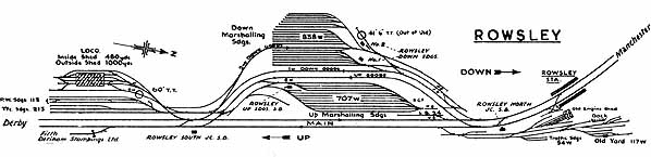
Rowsley Sidings (the MR used the term Sidings rather than Marshalling Yard) were fully opened on 19th March 1877, together with goods lines that ran between separate Up and Down Sidings, often referred to in the early years as South and North Sidings. What is clear, however, is that part of the complex was brought into use much earlier and the working timetable for February 1876 shows a good number of trains interchanging traffic at Rowsley, with some starting and terminating there.
The Up Sidings, which were at a slightly lower level for part of their length, consisted of 12 roads and could be shunted from the Up goods line and from both ends. The Down Sidings had 15 roads and could be shunted from the Down goods line, and at the northern end. A signalbox was situated in each group of sidings.
Initially, traffic consisted mainly of general goods trains, with Express Goods services operating during the evening and night times. Mineral workings were less common, but expanded considerably in later years as coal began to moved from the Nottinghamshire and Derbyshire Coalfields to the industrial areas and ports of Lancashire. The Express Goods operations continued throughout the life of the Sidings, many of the road allocations being different during the evening and night time from those during the day. Indeed, some of the services shown in early time tables were still running in similar times when the Sidings closed.
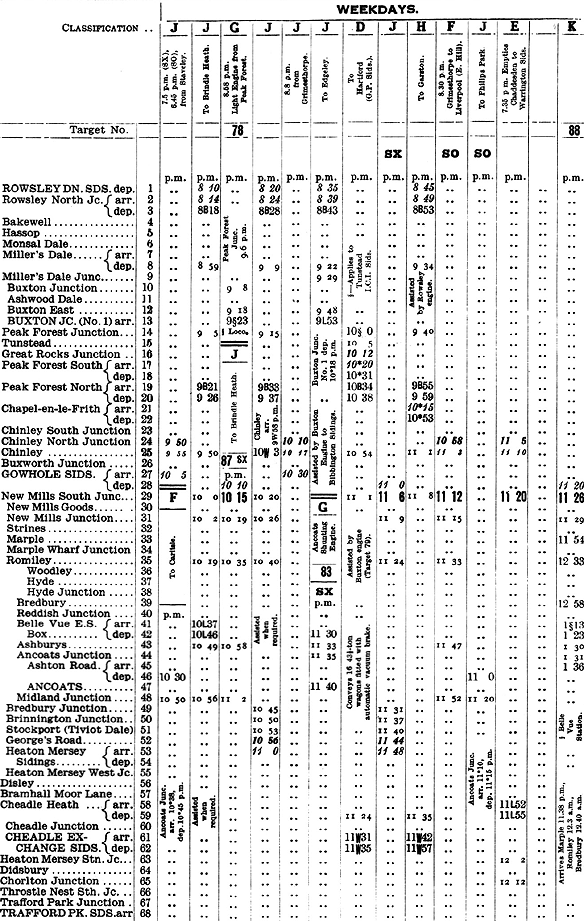 A page from the Freight Working Timetable for July 1951 showing four departures from Rowsley Down Sidings in a 35-minute period during the evening. All four showed a stop at Rowsley North Junction, the letter “B” indicating that this was to attach a bank engine at the rear, although in the first two cases there was a column note stating “Assisted when required” – which indicated that the loads may not have exceeded that of a Class 4F on a regular basis. On the other hand, the column note for the 8.45pm to Garston – a heavy train with export coal – states a banker was definitely required.
 |
In November 1911 the MR set up one of its Control Offices at Rowsley. This was initially located on the Up platform at Rowsley’s second station, but was soon moved to a wooden building at the southern end of the Up Sidings. This covered the whole of the route from Whatstandwell to Peak Forest and Buxton. Following the grouping in 1923 it also became responsible for part of the Buxton to Ashbourne line and the Cromford & High Peak Railway. The work was transferred to Derby and the Control Office closed in January 1949.
In July 1927 the Chief General Superintendent of the London Midland & Scottish Railway reported that the Down Sidings were inadequate for the traffic levels. This was partly due to the need to hold back wagons at Rowsley due to insufficient capacity at Buxton and the recent re-routing of traffic from the southern end of the Cromford & High Peak line via High Peak Junction rather than the northern outlet. It was therefore agreed that seven additional sidings should be provided capable a further 193 wagons and 33 cripples. The extension of the Down Sidings was brought into use on 9th September 1928. The new layout required two signalboxes, while one of the roads that split the two fans became an additional reception line. This was officially named the 2nd Down Goods, but was known locally as the Coal Road, as it was mainly used by that type of traffic.
A feature associated with Rowsley Sidings in the northbound direction was the banking of trains up the 15 mile more-or-less continuous gradient to Buxton and Peak Forest. Initially, assistance is believed to have mainly been provided from the front. However, almost all wagons were unbraked and if a wagon coupling broke on a train on this section of line, only the guard’s brake could prevent the vehicles behind that point from running away towards Rowsley. On 1st November 1903, the Board of Trade carried out tests at Peak Forest, based on a worse case scenario of a break loose occurring between the engine and the first wagon. It therefore deemed that any train conveying in excess of 226 tons should have a bank engine at the rear for safety.
An ingenious arrangement of running a number of double mineral trains from Rowsley to Peak Forest with brakevans in both the middle and ends of trains, and two engines at the front (the pilot engine being a Class 1 goods type), was introduced in July 1906, but this would appear to have been discontinued after a few years.
It would also appear that by the late 1920s, the BOT ruling of 1903 was not being strictly adhered to. Bigger engines and stronger brakevans were now being used, and on 5th March 1930, a new instruction was issued which stated that trains which exceeded the scheduled load for a Class 4 freight engine, must have a bank engine in the rear. That instruction was still in force when freight trains were diverted from the line on 3rd October 1966, the scheduled load for a Class 4F then being 295 tonnes.
Some statistics exist for March 1937, which show that during the week ending Sunday 21st March 8,942 wagons were shunted on the Up side alone, and that on Wednesday 24th March 1,705 were shunted in a single day. Such efficiency in operation would not have been possible had the wagons been fitted with vacuum brakes, of course.
During 1963 studies were carried out on what were considered to be duplicate routes, one of which was the line from Derby to Manchester. One recommendation was that the line should be closed between Matlock and Peak Forest Junction following the completion of the Euston to Manchester Piccadilly electrification, although, as it turned out, this would be done in stages.
It came as a great surprise to those who worked at Rowsley when it was announced at the end of January 1964 that the Sidings would be closed and that banking of freight trains between Rowsley and Buxton / Peak Forest would cease. The target date for closure was given at 23rd March. Consultation meetings took place at the beginning of that month. The case for the withdrawal of banking engines floundered as the safety aspects as the updated instructions of 5th March 1930 could not be rescinded. There was to be no reprieve for the Sidings, however, other than short stay of execution to 23rd April.
The closure of the Sidings duly took place on 23rd April. Traffic had certainly declined in recent years, but even during the last week of operation, when operations were being run down, 3,383 wagons were detached on the Down side and 4,543 on the Up.
Rowsley Up Sidings signalbox was taken out of use on Monday 4th May. The Sidings were not immediately lifted, however, and on the 12th of the month it was agreed that they could be used for the stabling of empty mineral wagons and loaded “one journey only” wagons of loco coal. On 4th June it was reported that there were 550 “OJO” wagons in the Down Sidings and 250 empties in the Up Sidings. On 2nd July it was instructed that the stabled wagons should be accommodated elsewhere. The Down Sidings No.2 signalbox was subsequently closed on 16th August, but it was 20th December before the No.1 box was taken out of use, indicating that the removal of the OJO wagons took a little longer than originally envisaged.
The banking of through freight trains continued until 3rd October 1966, when they were diverted away from the line. Type 2 diesels had replaced steam engines on banking duties on 4th January 1965. The goods lines that divided the two sets of sidings also continued until 3rd October 1966 as they were used for recessing trains requiring a crew change, and for regulation.
Source: Rowsley : A Rural Railway Centre by Glynn Waite and Laurence Knighton, (Midland Railway Society), 2003 ISBN 0-9537486-2-6. - available from the Rowsley Association.
Click here for Rowsley 1st Locomotive depot
Click here for Rowsley 2nd Locomotive depot
Click here to see a series of pictures of the A6 bridge at the north end of Rowsley station being replaced in 1965.
To see other stations between Manchester Central & Matlock click on the station name:Manchester Central, Chorlton-cum-Hardy, Withington & West Didsbury, Didsbury, Heaton Mersey, Cheadle Heath, Hazel Grove (Midland), Buxworth, Chinley (2nd site) STILLOPEN, Chinley (1st site), Chapel-en-le-Frith Central, Peak Forest, Cheedale Halt, Buxton (Midland), Blackwell Mill Halt, Millers Dale, Monsal Dale, Great Longstone, Hassop, Bakewell, Rowsley (1st site), Rowsley South PEAK RAIL, Darley Dale, Matlock Riverside PEAK RAIL & Matlock STILL OPEN. See also Stockport Tiviot Dale & Stockport Portwood |

shed_old41.jpg)
shed_old39.jpg)
old50.jpg)
sidings_old72.jpg)
sidings_old73.jpg)
shed_old37.jpg)
second32.jpg)
old_thumb50.jpg)
sidings_old_thumb76.jpg)
shed_old_thumb38.jpg)
old_thumb52.jpg)
old_thumb53.jpg)
shed_old_thumb57.jpg)
first_old_thumb12.jpg)
sidings_old_thumb75.jpg)
second_old_thumb47.jpg)
sidings_old_thumb71.jpg)

 Home Page