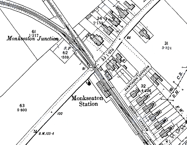
Note: The station was on an alignment some 50 yards north-east of the present Monkseaton Metro station, immediately east of the junction with the Avenue Branch (to Hartley) and the Marine Avenue level crossing. It opened on the day that the New Bridge Street (Newcastle) to Tynemouth services began. There were two paved platforms. On the west platform the main single-storey building was of brick, with round headed windows. The hipped roof was topped by iron cresting and three chimney stacks. A hipped awning sheltered the platform. Screen walls, pierced by paired round-headed openings, extended from the building at either end of the awning. On the east platform stood a smaller hipped-roofed building, accompanied by a similarly roofed signal box, adjacent to the level crossing.
 |
The station was rebuilt on the same site in September 1968. It was renamed Monkseaton (1st site) on 3 July1882 when a new route to Tynemouth was opened closer to the coast, on which a new Whitley station (3rd site) – later renamed Whitley Bay – was located. Monkseaton (1st site) was replaced on an adjacent site in 1915 with a larger facility (Monkseaton 2nd site) to |
accommodate trains on the abortive Collywell Bay branch. The 1915 station remains open on the Metro system.
BRIEF HISTORY OF BLYTH & TYNE RAILWAY (Hartley-Monkseaton ‘Avenue Branch’; Monkseaton / Whitley Bay / Tynemouth area)
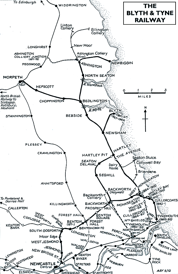
| The southern end of the Blyth & Tyne Railway has a complicated history. Until 1861 there was a single route south from Blyth and Seghill through Prospect Hill to Percy Main, with a terminus adjacent to the NER station. However that year a new branch was opened, following the route of the former Whitley Waggonway, extending from Hartley to Tynemouth. It should be noted that this included the line to what is now Monkseaton, which was to be known as the ‘Avenue Branch’; the line beyond to Tynemouth was half a mile inland of the present day Monkseaton – Tynemouth Metro line. |
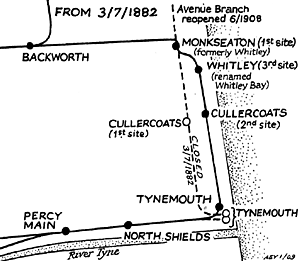 |
At the Tynemouth end the original terminus was quickly replaced with a new one on a short branch which curved south-eastwards, and that in turn closed when its branch was extended to a third terminus, which adjoined the 1847 Tynemouth terminus of what had been the Newcastle & North Shields Railway. These developments are shown on the series of accompanying maps.
| In 1864 the Blyth & Tyne reached Newcastle, with its terminus at New Bridge Street. This was achieved by diverting trains onto a new line just south of Holywell, through Backworth, Benton, and Jesmond. From Backworth a new line was opened to join the 1861 Whitley (Monkseaton) to Tynemouth route. Trains could now travel on the B&T from Newcastle (New |
 |
Bridge Street) to Tynemouth, making the Holywell – Prospect Hill – Percy Main route, and the Avenue Branch between Hartley and Whitley (Monkseaton) redundant. These two lines closed in June 1864 on the day when the Newcastle – Tynemouth service was inaugurated. In June 1904 the Avenue Branch reopened to passenger traffic.
.gif) |
In 1874 the B&T was absorbed by the NER, and the opportunity was taken to reorganise the railway routes in the Monkseaton / Whitley / Tynemouth area. With the growth of housing and holidaymaking on the coast the ‘inland’ route from Monkseaton to North Shields was superseded in 1882 by one within sight of the sea, and the two formerly competing termini at Tynemouth were replaced with a splendid new through station. This created the coastal section of the familiar Coast Circle and Metro route, although there were to be realignments at Whitley Bay in 1910 and Monkseaton in 1915 where new, larger stations were built.
Click here for a list of sources and a Blyth & Tyne bibliography
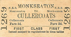
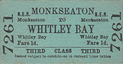
1887 Bradshaw from Chris Totty, 1906 Bradshaw from Chris Hind. Tickets from Michael Stewart & from CJ Dean. Route map drawn by Alan Young.
To see other stations on the Blyth & Tyne Railway Avenue branch click on the station name: The Avenue, Dairy House, Whitley, Cullercoats (1st site), Tynemouth (1st site), North Shields (B & T) & Tynemouth (3rd site)
See also Seaton Sluice and the unopened Collywell Bay branch: Brierdene & Collywell Bay
See also
West Monkseaton, Monkseaton (2nd site), Whitley Bay (1st site), Whitley Bay (2nd site), Cullercoats (2nd site) & Tynemouth (4th site)
See also
Tynemouth (Newcastle & Berwick terminus) |

c1915)first_old1.jpg)
.gif)
first_old2.jpg)
first1.jpg) Looking north-west from the Marine Avenue level crossing in July 1987 towards the junction. The first Monkseaton station was behind the photographer.
Looking north-west from the Marine Avenue level crossing in July 1987 towards the junction. The first Monkseaton station was behind the photographer.first2.jpg)
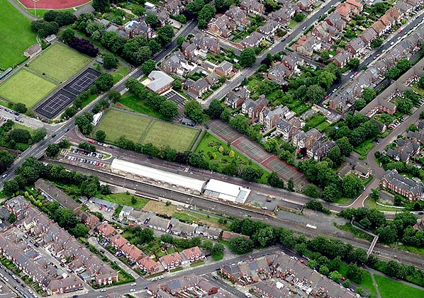
first4.jpg) Looking north-west at the site of the first Monkseaton station in May 2012. The site of the station buildings now lies under the car park and the Marine Avenue medical Centre seen in the background.
Looking north-west at the site of the first Monkseaton station in May 2012. The site of the station buildings now lies under the car park and the Marine Avenue medical Centre seen in the background.first6.jpg)
first_thumb3.jpg)
first_thumb5.jpg)

 Home Page