Note: Jesmond Metro station immediately north-west (opened 11.8.1980) replaced the ex-B&T station.
 |
When opened Jesmond was on the outskirts of the built-up area of Newcastle and served a prosperous residential suburb whose residents could be expected to travel first or second class – in contrast to the dominantly ‘third class’ clientele of the northern part of the B&T system. The station’s almost rural character survived into the 1970s, and this possibly encouraged |
the staff to maintain it and carefully tend the station garden. Their efforts were rewarded with certificates awarded in the North Eastern Region’s ‘Best Kept Station’ competition, proudly displayed in the booking hall.
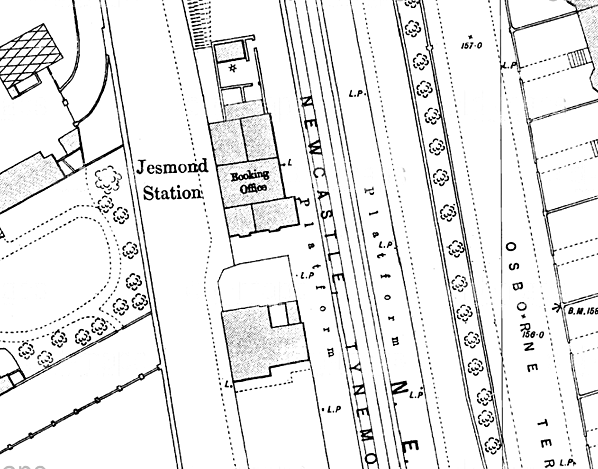
The buildings towards the north end of the down platform consisted of a lofty single-storey Tudor gothic booking hall built of brick with stone quoins. Fawcett (2003) notes the similarity of this design (also formerly at South Gosforth) to some of Brunel’s GWR stations, such as Culham. He describes the structure as a three-cell building, with the roof ridges all in line but stepping down to different heights either side of the central portion. The separate stationmaster’s house was added in 1879. Fawcett remarks that the NER tried to provide an inexpensive dwelling for under £300, but the discerning local residents insisted on something of a more ornamental character. The result was a building decorated with lavish bargeboards; regrettably it was demolished in the mid-1970s.
| On the up platform was a wooden waiting shelter reminiscent of a large rabbit hutch. Passengers wishing to cross the line used Jesmond Road bridge which crossed over the railway to the north of the platforms. Under LNER administration Jesmond station was fitted with nameboards of a design that was probably unique to the Coast Circle stations incorporating the |
 |
company’s early diamond motif: in effect a spike above and below the centre of the board, and these were in place until about 1959 when BR(NE) vitreous enamel signs replaced them. The LNER also installed swan-neck electric lamps and nameplates, but BR did not fit totem signs. In 1971 tall ‘vandal-proof’ lamps replaced the LNER ones, and corporate identity signage followed in 1973.
Inner suburban stations proved vulnerable to competition from road transport, and, apart from Backworth, Jesmond booked least passengers of any of the Coast Circle stations in the 1950s. The light use resulted in the withdrawal of winter Sunday services from 1964 until 1970. Total closure came in 1978 in connection with conversion of the Coast Circle line to Metro light rail. A single track is retained through the station for empty Metro stock movements.
The platforms are intact and the station building is in use as The Carriage public house. On the same platform, a structure in the style of a signal box has been constructed which, together with an old Gresley brake carriage, are the premises of Valley Junction Indian Restaurant.
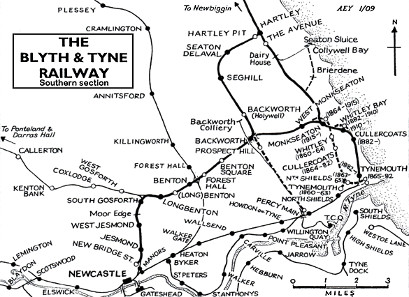
BRIEF HISTORY OF BLYTH & TYNE RAILWAY (Newcastle [New Bridge Street] – Jesmond – Benton – Backworth)
The southern end of the Blyth & Tyne Railway has a complicated history. Until 1861 there was a single route from Blyth and Seghill onward through Prospect Hill to Percy Main, with a terminus adjacent to the NER station. However in that year a new branch was opened, following the route of the former Whitley Waggonway, extending from Hartley to Tynemouth. It should be noted that this included the stretch to what is now Monkseaton, which was to be known as the ‘Avenue Branch’, and that the line beyond to Tynemouth was half a mile inland of the present day Monkseaton – Tynemouth Metro line.
At the Tynemouth end the original terminus was quickly replaced with a new one on a short branch which curved south eastwards, and that in turn closed when its branch was extended to a third terminus, which adjoined the 1847 Tynemouth terminus of what had been the Newcastle & North Shields Railway.
 |
In 1864 the Blyth & Tyne reached Newcastle, with a terminus at New Bridge Street. This was achieved by diverting trains onto a new line just south of Holywell, then through Backworth, Benton, and Jesmond. At Backworth a new line was opened to join the 1861 Whitley (Monkseaton) to Tynemouth route. Trains could now travel on the B&T from Newcastle (New |
Bridge Street) to Tynemouth, making the Holywell – Prospect Hill – Percy Main route, and the ‘Avenue Branch’ between Hartley and Whitley (Monkseaton) redundant. These two lines closed in June 1864 on the day when the Newcastle – Tynemouth service was inaugurated.
| In 1874 the B&T was absorbed by the NER, and the opportunity was taken to reorganise the railway routes in the Monkseaton / Whitley / Tynemouth area. With the growth of housing and holidaymaking on the coast the ‘inland’ route from Monkseaton to North Shields was superseded in 1882 by one within sight of the sea, and the two formerly competing termini at Tynemouth |
4.gif) |
were replaced with a splendid new through station. This created the coastal section of the familiar Coast Circle and Metro route, although there were to be realignments at Whitley Bay in 1910 and Monkseaton in 1915 where new, larger stations were built.
In response to the growth and electrification of street tram networks on North Tyneside the Coast Circle route via both Wallsend and Carville was electrified in 1904 on the third rail system, and the irregular and infrequent steam service was replaced with a frequent interval service. For almost six decades the basic pattern was three trains per hour in each direction, with extras in the rush hour.
 |
In 1963 the Reshaping of British Railways (‘Beeching’) report made no reference to the main Coast Circle line, but the Riverside Branch, via Carville, was recommended for closure (which was eventually implemented in 1973). However on a visit to Tyneside shortly after the report’s publication Beeching made it clear that the Coast Circle line was a likely candidate for closure. In the mid 1960s the ageing electric multiple units, dating from 1937, were being allowed a few more minutes to complete their journeys, and the decision was made to replace them with diesel multiple units cascaded from other areas rather than with newer electric stock. In June 1967, shortly after the line became part of British Rail’s Eastern Region – the North Eastern having been abolished - the last EMUs ran, and the third rails were removed.
 |
The service of three stopping trains per hour in each direction was replaced with a half-hourly service, plus one ‘express’ serving only the coastal stations, Wallsend and Manors; it is no surprise that custom was lost at the stations whose service was cut. However in October 1970 the tide turned, and the Eastern Region launched the vigorous Tynerider campaign to revitalise |
the line (including the Riverside branch) and the South Shields branch. Although the Riverside continued to have a sparse service at rush hours only, the Coast Circle’s 20-minutely service returned, with the new feature of trains in the early hours to bring revellers home from Newcastle city centre. Passenger numbers increased dramatically, and strengthened the case for further investment. The idea of incorporating the local railways into a rapid transit system was examined, and in 1973 Royal Assent was obtained to use the Coast Circle as the basis of such a network, which was to become the Tyne & Wear Metro.
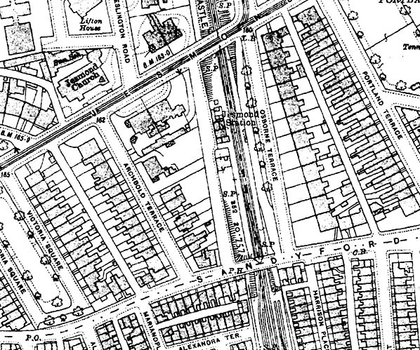
The engineering work to bring about this transformation was ambitious, involving the driving of tunnels under central Newcastle and Gateshead and constructing a sixth bridge over the Tyne between these centres, so that the Metro could be separated from the ‘main line’ system. For some time between January 1978 and November 1982 all of the stations on the Coast Circle (except Tynemouth) were closed for conversion work to be done: this included West Jesmond, South Gosforth, Longbenton, Benton, and West Monkseaton on the former B&T Newcastle route, thus their inclusion in the list of Disused Stations. Backworth closed in 1977 and Manors North in 1978 and were not to reopen on the new Metro line (although Manors underground station replaced Manors North, and Northumberland Park was opened in 2005 immediately south-west of the site of Backworth).
Almost all of the Newcastle – Backworth route remains as part of the Metro system. Only at the southern end has there been any significant change. A short distance north of the original Jesmond station the Metro route of 1980 curves to the south-west to enter the tunnel beneath central Newcastle and the new Jesmond station.
Click here for a list of sources and a Blyth & Tyne bibliography
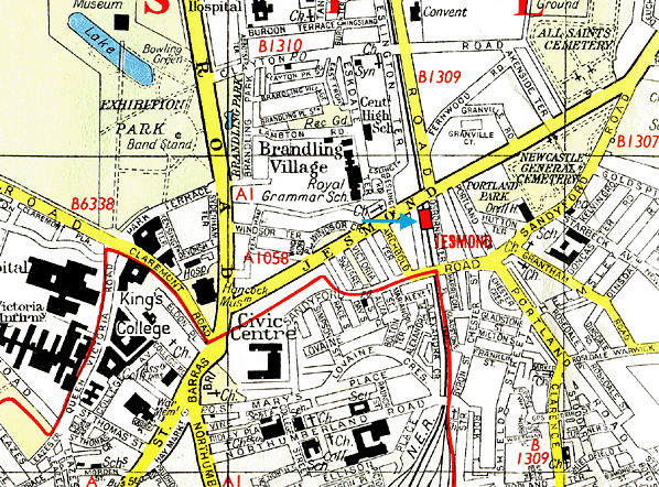
Tickets from Michael Stewart except 8219 CJ Dean and goods labels from Brian Johnson. 1906 Bradshaw from Chris Hind, 1864, B & T timetable from C J Dean. Street map from Ali Ford. Route map drawn by Alan Young.
To see other stations on the Blyth & Tyne Railway Newcastle - Backworth line click on the station name: Newcastle New Bridge Street, Manors North, West Jesmond*, Moor Edge, South Gosforth*, Longbenton*, Benton (1st site)*, Benton (2nd site)*, Forest Hall, Benton Square and Backworth (2nd site).
* Station reopened as part of the Tyne & Wear metro. Three other Metro stations on this line are new sites and are not included. These are Palmersville, Northumberland Park and Ilford Road. |

old18.jpg)
old8.jpg)
old4.jpg)
old3.jpg)
old5.jpg)
13.jpg)
16.jpg)
old17.jpg)
7.jpg)
10.jpg)
.gif)
old2.jpg)
old19.jpg)

 Home Page