
PENWORTHAM TRIANGLE[Source:Tony Graham & Paul Wright]
1.jpg) In July 1963, Stanier 2-6-4T No 42494 comes off the long, sweeping curve from the site of the former Middleforth Junction, with the 5:30 pm Preston - Southport and rattles over the point-work at Penwortham Junction. The tracks to the right carry straight on across the River Ribble into the former Preston WLR terminus, known in 1963 as Preston West Lancs Goods. The latter was a route, reduced by this time to a daily trip working carrying cattle foodstuffs to the depot of Messrs. J. Silcock & Sons, whose headquarters were in the old station buildings. Penwortham Junction was, in 1963, a ground-frame operated by the guards of trains requiring access to the branch, and the point-locking was released electrically as necessary by the signalman on duty at Whitehouse West Junction. Beyond the bridge and to the right was the large expanse of railway-owned land which had been appropriated on construction of the railway for use as storage sidings for rolling stock using the severely
congested old terminus. Photo by Alan Castle 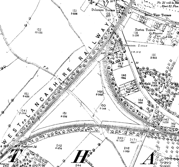 The Penwortham Triangle as shown on an 1893 map when all sides were operational and in regular use. Preston West Lancashire station was to the north on the other side of the River Ribble. Trains departing for Blackburn would have travelled over the eastern side of the triangle; those for Southport travelled over the west side. Through services between Blackburn and Southport used the southern side. 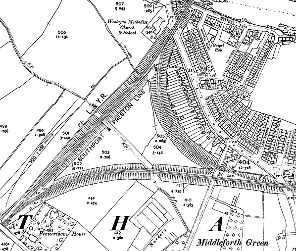
The Penwortham Triangle in 1912. By this time Preston West Lancashire station was closed to passenger services. The southern side of the triangle had become the main line into Preston, via the Whitehouse Triangle that lay to the east. The western side and the line up to Preston West Lancashire station had become a branch used only by goods services. Close observation shows that the lines on the east side had been disconnected at Middleforth Junction. It is not known why they were left in situ and still connected at Ribble Junction, but it is assumed that they were used as sidings.
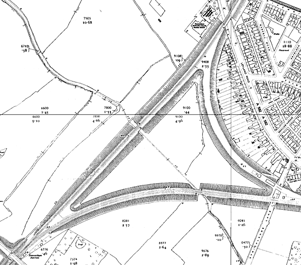
By 1960 there were effectively only two sides to the Penwortham Triangle although the embankment formerly occupied by lines on the eastern side is shown on this map. The main line between Southport and Preston, on the south side, was still in regular use. The original line leading to Preston West Lancashire Goods had been singled and was carrying only one weekday goods train. Close to Middleforth Junction on the former east spur, a scout hut is visible, erected on the trackbed.
2.jpg)
On 22 September 1962, having already propelled the 5 ex-LMS coaches forming the RCTS 'Mid Lancs Railtour' over the tracks to the right up from Preston (West Lancs Goods) former LNWR 'Super D' 0-8-0 No. 49451 had reversed and was about to traverse the short section towards Whitehouse South Junction. Penwortham Junction was a ground-frame that had been operated by the guard, the point locks released electrically by the signalman on duty at Whitehouse West Junction. After leaving the former WLR lines the train continued along former East Lancs Railway tracks through Todd Lane Junction, before turning right through Lostock Hall and onto LNW tracks-proper at Farington Curve Junction, completing a full circle in order to head north again towards another long-closed passenger terminus, that at Longridge.
Photo by Alan Castle 3.jpg) Looking north-east towards Penwortham Junction in August 1964. One of Southport's Caprotti valve geared Class 5s, No. 44745, shuts-off steam and rolls up the last few yards of the gradient into Penwortham (Cop Lane) station. 44745 was built by BR in July 1948 and entered service at Leeds Holbeck, where it stayed for 12 months before moving to 22A, Bristol Barrow Road. Further allocations were Derby and Bank Hall, before its final allocation to Southport on 17.3.1962. It was withdrawn on 24.10.1964 and cut up by Wards of Killamarsh in February 1965.
The reason for the apparently over-engineered three-arch overbridge for what is merely a farm track is that, upon construction of the original route into Fishergate Hill station, the WLR purchased a considerable area of land immediately to the left of the train for carriage-siding accommodation to relieve the severely congested terminus. Although not used for railway purposes for many years, the land remained in railway ownership until closure in 1964. Today the bridge has gone and in its place sprawl the lanes of the Penwortham bypass, all traces of the railway having been obliterated in the process. Photo
by Alan Castle
4.jpg)
In August 1964 Lostock Hall's long-serving Fairburn 2-6-4T No. 42286 rounds the curve between the site of the former Middleforth Junction and Penwortham Junction Ground Frame with the 6:59 pm Preston - Southport. The long-abandoned third side of the triangle from Middleforth Junction to Ribble Junction, which originally provided direct access from the East Lancashire line to the former original Preston West Lancs terminus at Fishergate Hill, can just be discerned in the background. By this time the trackbed, disused since 16 July 1900, had for some years been occupied by a hut belonging to the Middleforth scouts; this building can also be seen to the left of the rear coach,
Photo
by Alan Castle
bridge5.jpg) Looking north in August 1964 the 6:35 pm Southport - Preston service, headed bunker-first by a Fairburn 2-6-4T rumbles over Leyland Road Bridge, Middleforth, and slows to pass under the six tracks of the West Coast main line. It will then take the left-hand curve at Whitehouse West Junction and make the short climb beyond into the East Lancs platforms of Preston Station. Middleforth Junction is out of view to the left of the picture.
Photo by Alan Castle 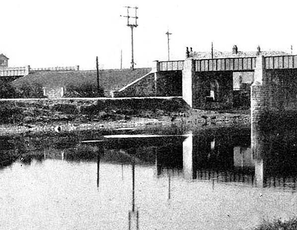 The northern point of the Penwortham Triangle was Ribble Junction, just south of the River Ribble. In this view from the late 19th century looking south-west the signal box that controlled the junction can just about be seen to the far left; this is the only known photograph of it. The fork of the junction itself was to its left, out of view. In the top centre the signals that controlled the junction in the up direction can be seen. The signal arms to the left controlled movements over the east spur to Middleforth whilst those to the right controlled the line to Southport via the west spur. The arms at equal height indicated that both spurs had equal status. junction11.jpg) Looking south towards the site of Ribble Junction, the northern point of the Penwortham Triangle, in January 2012. The actual junction was on the far side of the road (Leyland Road); the bridge was removed shortly after the line had closed in January 1965. Ribble Junction signal box was located on the right side of the line just beyond the advertisement hording.
Photo by Paul Wright junction17.jpg)
Looking north at the site of Penwortham Junction in January 2012. The original line to Preston WLR station continued straight on; the 1883 line to Whitehouse veered to the right.
Photo
by Paul Wright
junction6.jpg)
Looking east towards Middleforth Junction from the trackbed of the southern side of the Penwortham Triangle in January 2012. The actual junction was at a point within the housing estate seen in the background.
Photo by Paul Wright junction15.jpg)
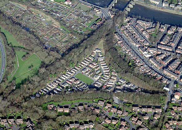
Looking east at the Penwortham Triangle from a point just south of Ribble Junction in January 2012. The tree-lined bank to the left of the picture was the Ribble Junction to Middleforth Junction spur. In the distance, at the far end of the Penwortham residential park (Park Road), can be seen the Middleforth Junction to Penwortham Junction spur. The residential park is located inside the triangle.
Photo by Paul Wright
|
junction_thumb7.jpg)
junction_thumb8.jpg)
junction_thumb9.jpg)
junction_thumb10.jpg)
junction_thumb12.jpg)
junction_thumb13.jpg)
junction_thumb14.jpg)
junction_thumb16.jpg)

 Home Page