Notes: Wikipedia, the online encyclopedia, includes, at the foot of its extensively referenced entry about Dereham Station, mention of a second station in the town. It states: Early Ordnance Survey maps show a second railway station located in the South Green area of Dereham on the branch line to King's Lynn. This line was originally provided with a number of stations that lasted less than a decade, and this second station does not appear in later documents.
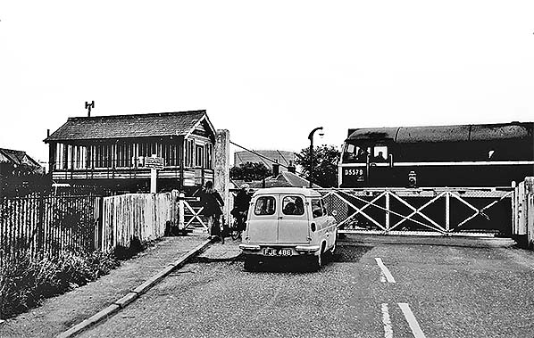
The station building was retained as a crossing keeper's cottage, and survived the closure of the branch - becoming a private residence. The building survives, and the entrance to the booking hall and former platform door, now converted to be windows, can be seen and compared to contemporary station buildings.
The online entry is not referenced to any sources for the information. The existence of a second station is not mentioned elsewhere online and is not mentioned in books about the Lynn & Dereham Railway. The railway had several short-lived stations, two closing after just three years and one more, Bilney, within fewer than twenty years from opening.
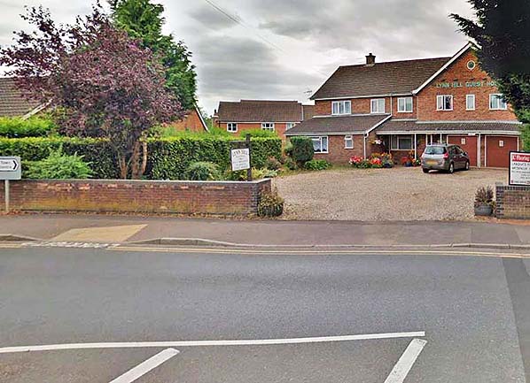
Whilst there has been some doubt about existence of the station, there is some convincing evidence of its short life. Michael Quick in his book ‘Railway Passenger Stations in Great Britain - a Chronology’ refers to a station opened on 11 September 1848 in Swan Lane. Immediately there is doubt because there is no modern trace of Swan Lane. However two mentions of the lane appear in old documents. Norfolk Record Office has them both: the first refers to an independent chapel in Swan Lane and asserts that the name is no longer known in the town. The second, also mentioned by National Archives, is about voting irregularity and is a ‘Letter from Jeremiah Martins, brickmaker, Swan Lane, East Dereham, complaining that he had not been given game in return for his vote’. Swan Lane was what is now London Road. There clearly is the surviving gatehouse on the west side of what is now Southend although it was part of Baxter Row at the time, 'Southend' seemingly being a later name for the southern end of the road that exists today; the cottage in London Road has been demolished and the site is now occupied by the Lynn Hill Guesthouse.
Michael Quick also states that relationships between the two railways were poor. It is unclear, however, whether the Lynn & Dereham’s station at Swan Lane was intended only as a temporary measure until matters could be resolved to complete the line to a junction south of the main station.
The minutes of East Anglian Railway (Lynn & Dereham) (EA) and Eastern Counties Railway (EC), contain only fragmented information on the station, but enough to prove that it did exist. In the minutes of the railway companies the first mention of the station dates from 17 July 1849. This minute concerns complaints from a Mr. Coote about charges for coal wagons per ton from ‘the East Anglia station at Dereham to stations of the Norfolk line being higher than those from Yarmouth and Lowestoft to the same stations’. Mr. Coote was a coal merchant, his firm later becoming Coote & Warren: 'Norfolk line' actually means 'Norfolk Railway’. On the same date, another minute recorded a problem with rates for flour from the EA station to Manchester, specifically that an increase from twenty shillings to twenty-five shillings resulted in the loss of this traffic to water transport. Presumably this in some way affected the Norfolk Railway and one would assume because flour was then conveyed from the EA station at Dereham via the Norfolk Railway to one or other of the East Anglian ports. What the quoted rates applied to is not mentioned but it was probably per ton. While the EA station was in use, the two Dereham station were referred to in the minutes as ‘EA station’ and ‘EC station’ so by default this confirms there were indeed two separate stations.
There are two further minutes from 17 July 1849. One concerns a complaint about the two shillings and sixpence per charge per wagon for transference between ‘the EA station and EC station at Dereham’ and the other is interesting because it signals the demise of the EA station .... ‘Booking of passengers at Dereham. East Anglian Co. ask for joint use of Eastern Counties Railway Co.’s office there on satisfactory terms, trains to arrive and depart from EC Platform’. The mention of ‘EC platform’ is not a simple as it may seem. The NR/EC station did not then have a bay and EA trains had to wait outside the station until ECR trains had arrived and departed, after which they drew into the station to collect passengers, then depart westwards. This brought complaints about poor connections but 'poor connections' was not defined. We can however assume that it meant connecting passengers had to wait on the platform while shunting was performed. Information thereafter is extremely patchy but what we do know is that the 'poor connection' complaints persisted until sometime in 1850 when it was decided to provide a bay at the west side of Dereham (ECR) northbound platform.
Checking timetable mileages we find that in British Railways days, the mileage between Dereham and Wendling was 4 exactly. The March 1850 Bradshaw (timetable) gives identical mileage and there is no mention of through passengers having to transfer between stations in Dereham, so we can take it the original (EA) station had closed by March 1850.
Therefore, from the above information, we can conclude that Dereham's EA station was in use between 1848 and 1850. Patchy as the surviving minutes may be, it is enough to prove the EA station did exist.
Further evidence of the station is found in Journal 20 of the Great Eastern Railway Society which states: A second route to Dereham was brought into use on 11th September 1848 with the opening of the Sporle - Dereham section of the Lynn and Dereham Railway. Connection with the Norfolk Railway was brought into use the following year, the junction south of Dereham facing northwards, precluding through running between Norwich and King’s Lynn without reversal.
This suggests there was no connection with the Norfolk Railway until 1849 which must mean if passenger services ran between Sporle and Dereham, which we know it did, there must have been a separate station on the EA at Dereham.
Wikipedia states the station is shown on early Ordnance Survey maps. The first 6” and 25” map of Dereham were published in 1884 which is too late to have shown the station, so it must be a 1” map which may have been published around 1850. It has not been possible yet to see a copy of this map. Wikipedia includes a photo of the existing gatehouse on the west site of Southend, it states that the gatehouse was originally the station building. The station's location adjacent to what was Swan Lane actually makes much more sense than Baxter Row/Southend as it is closer to the Norfolk Railway's station and the track up to that point would have been the property of the Lynn & Dereham/East Anglian Railway. A map has recently come to light that confirms the position of the station on the west side of the Swan Lane (London Road) level crossing. The map is dated 1859 which is after the station closed. It shows the Norfolk Railway’s Dereham station which opened 11 February 1847 and it shows the junction with the Lynn & Dereham line south of the station. It is not uncommon for maps to show stations as open some years after they have closed.
An estate map for a land sale in 1850 came to light in early 2023 (above), this clearly shows the station, station building and a platform.
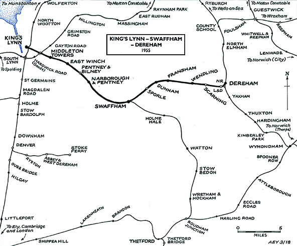
Route map dawn by Alan Young.
Click here for a brief history of the Lynn & Dereham Railway
See other stations on the Lynn - Dereham line: Middleton Towers, East Winch, Pentney & Bilney, Narborough & Pentney, Swaffham, Sporle, Dunham, Fransham, Wendling & Scarning |

 1859 1:63,360 (1" Norwich sheet 66) map. Although published in 1859 the survey woukd have been some years earlier.
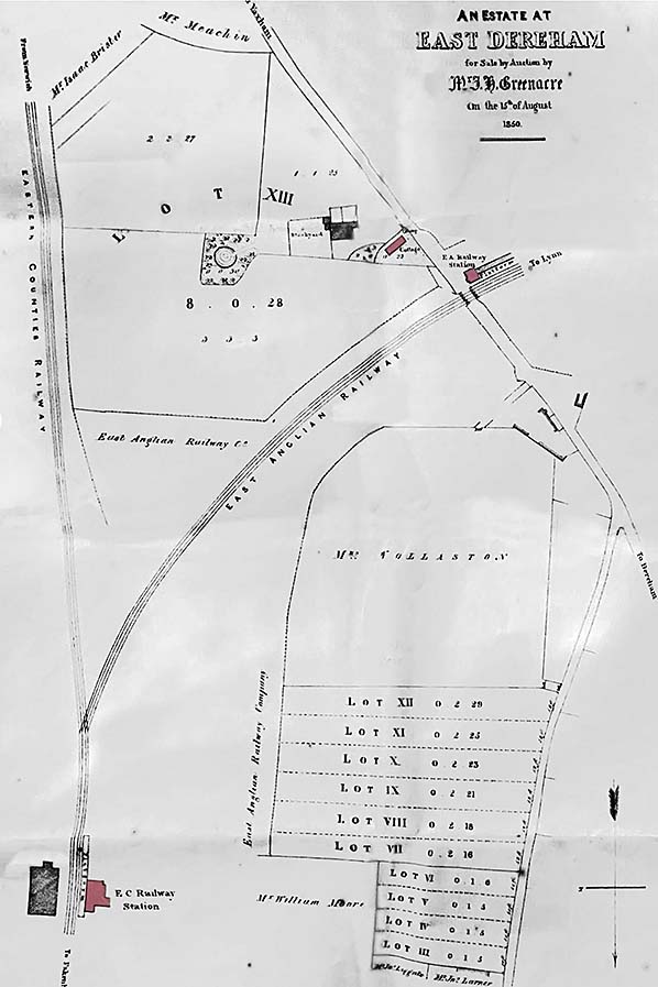 1850 estate map clearly shows the station complete with building and platform.
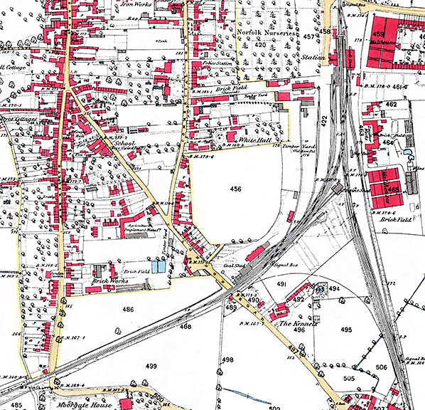
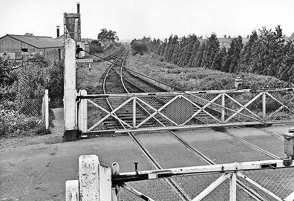
 The site of Dereham (EAR) station from the site of the Swan Lane/London Road level crossing in May 2016. The station would have been where the hedge is seen.
 Home Page