
Coundon Road Station: Gallery 1  Coundon Road station in the 1890s. The surrounding area around the railway and Coundon Road station itself was rural with little to no housing or industries surrounding it.
Photo from Coventry City Local Studies Collection 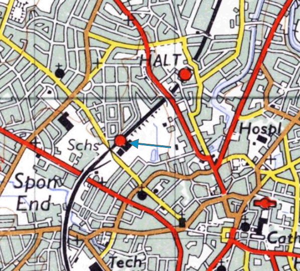 
Coundon Road station as seen on an 1888 1`:500 feet Ordnance Survey (OS) First Edition map. The area at this time was rural and had no housing or industry present.

Coundon Road station as seen on a 1906 Ordnance Survey Second Edition 1:2,500 map. By this time, a coal wharf had opened directly south of the station. As well as housing being built on Coundon Road.
 Coundon Road station as seen on a 1950 1:2,500 OS map. By this point, housing was now built directly on Baker’s Butts Lane, opposite the station.

Coundon Road station as seen on a 1972 1:2,500 OS map. By this time, the station can be seen as disused. The line remains in use at this point.
 Coundon Road in the 1930s, the signal box can be seen directly behind the car to the centre-right of the image. The view is looking from Baker's Butts Lane towards the Coundon Road level crossing. The bus in the top left corner is a Daimler bus, which was a common bus built by the nearby Daimler Company and operated by the Coventry Corporation Transport in their bus fleet around the city. These were commonly painted in maroon and cream colour, and were the common uniform of the bus company at the time. To the right, is also an underbridge. This led down to a farm track but was used by small cars to bypass the waiting at the level crossing. This road has since been converted partly into a footpath
Photo from John Mann collection old7.jpg) An aerial view of Coundon Road station, level crossing and the sidings to the adjacent coal wharf in 1934. Click here to see a larger version
Photo from Britain From Above (EPW046373) reproduced with permission  old3.jpg)
Coundon Road railway station looking towards Coventry, from the down platform in 1953. The station master's house can be seen behind the up platform and its waiting shelter. The down platform’s shelter is to the right of the photo, and the Coundon Road signal box is in the distance to the right. The up platform was served by services heading to Coventry. The down platform was served by services heading to Nuneaton via Bedworth. There were also some services extended to Leamington Spa via Kenilworth. LMS Hawkseye signs were still in use at this time. Coundon Road coal wharf is opposite the signal box.
Copyright photo from John Alsop collection 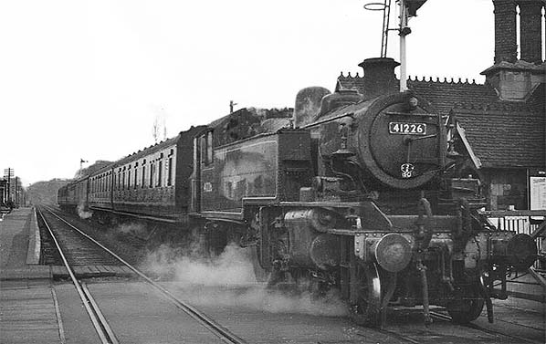 An Ivatt Class 2MT tank engine (number 41226) passes through Coundon Road station in the 1950s. heading towards Coventry. The station house can be seen to the right of the train and the down platform towards Nuneaton to the left. The engine 41226 was a commonly used locomotive on the wider Midlands rail network at the time. It was built by the Crewe Works in 1948 and was used for both passenger and freight services during its lifespan. They were later scrapped in the late 1960s, during the transition from steam to diesel and electric across the entire British Railways Network. There are no engines of the same class as 41226 surviving in preservation or heritage use today.
Photo from John Mann collection 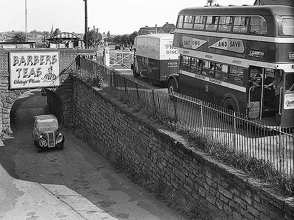 The level crossing at Coundon Road, as can be seen in this photo. The delivery van, possibly a Bedford PC or a Morris Commercial PV can be seen waiting at the level crossing gates with a Daimler CVA6 or a Daimler CVG6 double decker bus. These two vehicles are waiting for the level crossing gates to be opened by the resident station master at Coundon Road station house. Meanwhile, at the bottom left of the photo. A Ford Anglia (E04A) or a Ford Popular (103E) is using the old farmers access lane to bypass the level crossing, this had a very low height restriction and as can be seen was rather too low for a delivery van or a bus.
Photo from John Mann collection old4.jpg)
Coundon Road station in June 1964, looking north towards Bedworth and Nuneaton along the line. The main station buildings on both the up and down platforms were typical of stations along the Coventry-Nuneaton line. Some also had their own station master’s house due to some of the level crossings along the route. BR signage (running in boards and totems) are now in use.
Copyright photo from Stations UK

A close up view of the waiting shelter at Coundon Road station in the 1960s. This was an example of the many waiting shelters used at most stations along the line and at most of the stations built and owned by the London and North Western Railway at the time.
Photo by H. F. Wheeller and H. B. Priestley
old6.jpg)
The platforms at Coundon Road station in the 1970s, this time the photographer is standing on the up platform towards Coventry. In the photo, the down platform towards Nuneaton is visible and still has its original waiting shelter in place. Unlike the up platform, which had its building structures demolished, the down platform's building structure remained in situ but would be finally demolished in the late 1970s.
Photo from John Mann collection )road7.jpg)
The platforms at Coundon Road station in the 1970s. The photograph is facing towards the up platform, towards Coventry. By this time, the station had been in a post-closure state. The canopies and station buildings have been demolished as well as the stone edges, later on, due to health and safety regulations. The photographer is standing on the down platform, towards Nuneaton.
Photo from John Mann collection old5.jpg) Coundon Road Station Signal Box was erected in 1876, and was one of the last manually controlled signal boxes within the Coventry area. The signal box remained a landmark of the former Coundon Road station after it closed to passengers, surviving until 2014. Coundon Road Station Signal Box was erected in 1876, and was one of the last manually controlled signal boxes within the Coventry area. The signal box remained a landmark of the former Coundon Road station after it closed to passengers, surviving until 2014.Photo from John Mann collection road9.jpg)
The site of Coundon Road station in 1980, the station had been closed for 15 years by this time. The passing train in the photo is heading towards Coventry. The photo was taken from the down platform.
Photo
by John K Wells
road9.jpg) The site of the coal wharf in 1983. By this time, the yard was mostly disconnected from the national rail, and the sidings had been lifted. The yard remained in use at this time for Co-op fuels and other merchants until its full closure in September 1983. Coal merchants' huts are seen on the left. The site of the coal wharf in 1983. By this time, the yard was mostly disconnected from the national rail, and the sidings had been lifted. The yard remained in use at this time for Co-op fuels and other merchants until its full closure in September 1983. Coal merchants' huts are seen on the left.Photo by Mark Smithers
|

 Notes: Coundon Road was situated on the London and North Western Railway's (LNWR) Coventry-Nuneaton Line. Named after the Coventry suburb of Coundon, it was the first intermediate station north of the city centre. The station was located at a level crossing-the last surviving crossing within the immediate Coventry city boundary following the removal of those at Canley and Tile Hill in 2002 and 2004 respectively, during West Coast Main Line (WCML) infrastructure upgrades.
 Original intermediate stations included Coundon Road, Foleshill, Longford & Exhall, Hawkesbury Lane, Bedworth, and Chilvers Coton. Daimler Halt was added later as a private station for workers at the adjacent Daimler Company factory. A further station, Radford Road, was constructed between Coundon Road and Foleshill but never opened to the public, reputedly due to disputes between the LNWR and Coventry City Council. Although the station building survived for over a century, it never served a scheduled passenger train.
 Following the 1923 Grouping, the line became part of the London, Midland and Scottish Railway (LMS), passing to British Railways (London Midland Region) upon nationalisation in 1948. The first station closure occurred that year at Longford & Exhall. The remaining intermediate stations, including Coundon Road, were withdrawn from passenger service on 18 January 1965 under the Reshaping of British Railways (Beeching) report.
 The coal yard remained open with coal coming in by road. In 1964 it was bought by Gordon Loakes, who had previously been a depot manager, however he went bust in 1965 and the yard was taken over by Morton's Fuel and Supplies Limited, part of the Maurice James Group (they already had depots in Binley and Baginton). In early 1967, J Coates & Son of Broomfield Place were operating from the yard and by 1968 the yard had been taken over by Co-op Fuels. There were 8 - 10 coal merchants operating from the yard the largest being Poretta's which are still based on the Radford Road. It became Coventry Coal Concentration Depot and finally closed September 1983.
 Passenger services on the main line were partially restored on 16 May 1987 with the reopening of Bedworth station, followed by the addition of Coventry Arena and Bermuda Park in 2016. Coundon Road Signal Box was officially closed on 23 May 2009, with control transferred to the West Midlands Signalling Centre. The structure remained a local landmark until its demolition in January 2014.
 Home Page