
Station Name: BLAYDON
|
| Date opened: | 10.3.1835 |
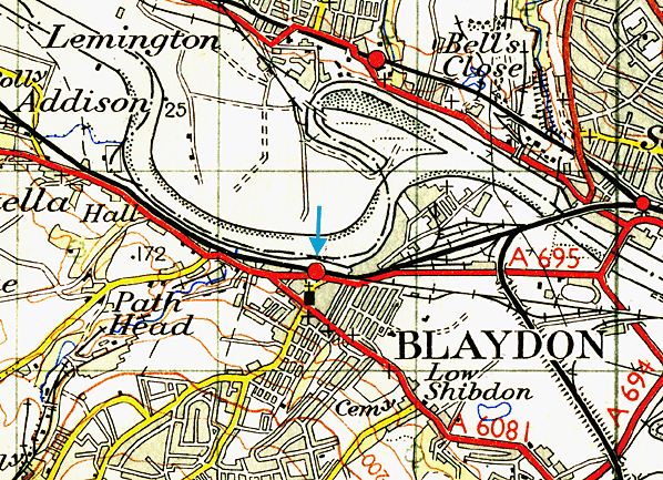
| Location: | Immediately north of Tyne Street (A695) |
| Company on opening: | Newcastle & Carlisle Railway |
| Date closed to passengers: | Still open |
| Date closed completely: | Still open |
| Company on closing: | Still open |
| Present state: | Still open |
| County: | Durham |
| OS Grid Ref: | NZ184635 |
| Date of visit: | September 1962, August 1972, April 1977, March 1978 & November 1996 |
|
Notes: The original station had a small, single-storey building, narrow platforms, and a primitive trainshed. In 1881 the Board of Health received a complaint about the inadequate facilities, prompting the NER to make improvements. In 1912 elegant new buildings were constructed. Most of the tall, single-storey structure was red brick. 97 yd glazed awnings of ridged cross-section covered much of the two platforms. They ended with glazed screens and were supported by iron columns and spandrels of a hooped design, as at West Jesmond (opened 1900). A covered footbridge linked the platforms. The lengthy exterior possessed restrained dignity. The lofty central section carried a pavilion roof. Its segmental-arched openings were separated by four sandstone pilasters that rose above the eaves and were capped by large ball-finials. A cross-gable window concealed and lit the footbridge, and was complemented by dormer-style ventilators on either side. The up platform had an unremarkable single-storey building with a pitched roof, flanked by high walls to support the awning. Blaydon had extensive sidings, handling Newcastle-Carlisle derived traffic, also waggons from the East Coast main line via Derwenthaugh, the Derwent Valley, local collieries, and other businesses. An engine shed existed from early N&CR days, but a larger one opened in 1900 for goods and passenger locomotives. In 1930 there were 84 locomotives based there. Under BR, Shed 52C bade farewell to steam locomotives in March 1963, and closed two years later.
ungainly and attracted local graffiti artists. Vandals smashed what was breakable; an arsonist attempted to destroy what was left. In Off the Rails (1977), the companion booklet to Save Britain’s Heritage exhibition of endangered railway architecture, I contributed the ‘Demolished and Maltreated Stations’ chapter. I remarked that Blaydon was probably Britain’s least attractive station. Local television and newspapers seized upon this and insisted on action to rectify matters. BR’s response was, rather than repairing the buildings, to bulldoze them later that year and install ‘bus shelters’! From being a busy station issuing over quarter-of-a-million tickets, and at which almost every train called, Blaydon now has only a token service, currently the station is served by just three Hexham-bound trains and three Newcastle-bound trains on Mondays to Fridays. On Saturdays there are three Hexham and two Newcastle trains. There are no trains at all on Sundays. It is poorly sited to serve a town with excellent bus links, being isolated from the town centre by a main road; immediately to its north is the River Tyne, so there is no hinterland in that direction. Beeching recommended Blaydon station for closure, but it was reprieved. It remains to be seen how much longer it will survive.
The Newcastle (or, more accurately, Gateshead) to Carlisle line was the first to cross the breadth of England from the east to the west coast. Horse-drawn goods trains commenced between Blaydon and Hexham in late-1834, and passenger services on 9 March 1835. Newcastle passengers were conveyed to and from Blaydon by horse-omnibus or boat. Steam locomotives hauled passenger trains from the opening day. On 11 June 1835 a 1¼ mile extension opened eastwards to Derwenthaugh, followed by 7½ miles from Hexham to Haydon Bridge on 28 June. Carlisle to Blenkinsopp Colliery, near Haltwhistle (20 miles), opened on 19 July 1836. On 1 March 1837 trains were introduced on the 2½ miles from Derwenthaugh to Redheugh (Gateshead), passengers being ferried by steamboat across the Tyne to a ‘station’ in Newcastle at No. 66 The Close, where the later High Level Bridge crossed the river. (The Close was one of a scarce breed of rail-less stations in Britain, others being Dartmouth and Hull Corporation Pier.)
N&CR rails reached Newcastle via a three-mile route including a ‘temporary’ Tyne bridge at Scotswood (which was eventually replaced with the present structure in 1870). Formal opening to a station at Railway Street, close to the Shot Tower, took place on 21 May 1839; regular services began on 21 October. The new Forth terminus, replacing that at Railway Street, opened on 1 March 1847. From 1 January 1851 the company used Newcastle Central, shared with the York, Newcastle & Berwick Railway. Although access to Carlisle Citadel had yet to be achieved, the 60½-mile route was complete.
The Newcastle & Carlisle was absorbed into the North Eastern Railway empire in July 1862. Its eccentric arrangement of right-hand running was discontinued after the re-signalling of the route for the standard left-hand operation in 1863-4. In the 1960s the transformation of the townscape surrounding the railway between Newcastle and Blaydon began. Many of the terraces of two-storey Tyneside flats were demolished and high-rise blocks took their place, and more recently the Elswick works site has been all but cleared and redeveloped as a business park.
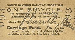
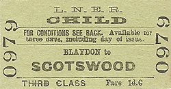
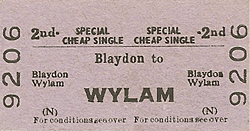
Tickets from Michael Stewart Sources:
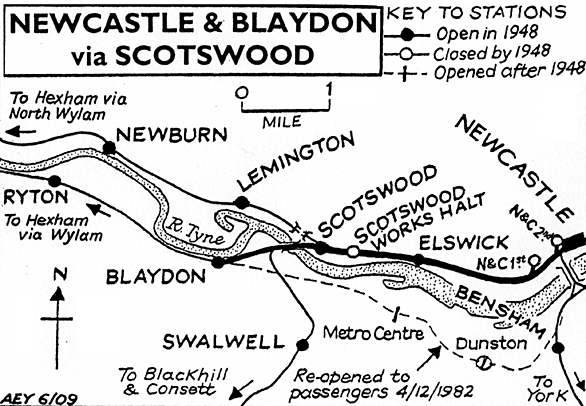
To see other stations on the Newcastle - Blaydon click on the station name: Newcastle (N & C 1st site), Newcastle (N & C 2nd site), Elswick, Scotswood Works Halt & Scotswood |
old1.jpg)
Copyright photo from John Alsop collection
old4.jpg)
Copyright photo from John Alsop collection
3.jpg)
Photo by Alan Young
4.jpg)
5.jpg)
Photo by Steve McShane reproduced from Wikipedia under Creative Commons Licence
old_thumb2.jpg)
old_thumb3.jpg)
old_thumb5.jpg)
old_thumb6.jpg)
|
|
thumb1.jpg)
thumb2.jpg)

|
 Home Page
 | Last updated: Sunday, 04-Jun-2017 09:50:20 CEST |
© 1998-2009 Disused Stations
|