
Station Name: BLACKFRIARS (SER Station)[Source: Nick Catford]
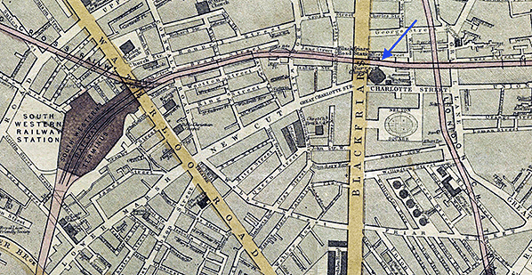
1868 Map of London by Edward Weller (Click here for a large version)
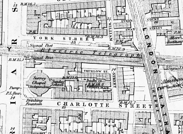
1879 1:2,500 OS map. Although this map was published 10 years after the station closed the platforms are intact. A side platform was originally planned for the north side of the formation but as no platform is shown here there is some doubt as to whether the platform was ever built. There is a clear widening of the viaduct to accommodate the platform. Blackfriars signal box is seen on the right. Click here for a larger version.
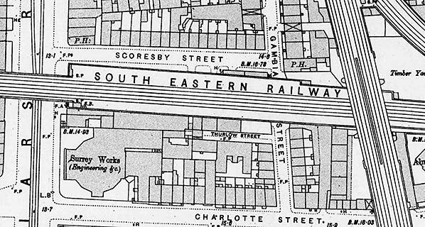 1:1,056 OS map. The platforms have now been removed and the track realigned. A widening of the viaduct on both side of the to accommodate the side platforms is seen, that to the north of the formation was probably never built. The Surrey Chapel in Charlotte Street has become an engineering works. A signal box now stands at the west end south side platform. Click here for a large version.
An 1881 painting showing a similar view to the engraving above. Again the entrance to Blackfriars station is visible under the bridge. Click here for a larger view,
Painting by John Crowther 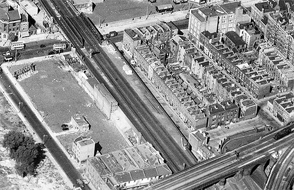
Aerial view showing the site of Blackfriars station in 1952. The widening of the viaduct for the north side platform is very obvious. The bomb damaged buildings in Charlotte Street to the south of the line have been cleared. This includes Revd. Roland Hill's Surrey Chapel which opened in 1783 and became a boxing arena known as The Ring in 1910. Click here for a large version
Photo from Britain From Above, reproduced with permission 7.jpg) Blackfriars station entrance on Blackfriars Road in June 2004. The inscribed panels on either side of the entrance have been filled in and painted over/
Photo by Alistair Fitchett 8.jpg)
Aerial view showing the site of Blackfriars station in December 2003. No trace of the station remains at track level other than a widening of the viaduct on both sides of the line to accommodate side platforms. It is unlikely the north side platform seen here was ever built.
1.jpg) Blackfriars station entrance in December 2008. The station entrance and inscribed stone panels were restored in 2005. Blackfriars station entrance in December 2008. The station entrance and inscribed stone panels were restored in 2005.Photo by Nick Catford 2.jpg)
The Charing Cross Railway inscribed panel in December 2008. Before restoration in 2005 the letters had been filled in and painted over and the panel was partially obscured by advertising hoardings.
Photo by Nick Catford 3.jpg) Blackfriars station panel in December 2008. Blackfriars station panel in December 2008.Photo by Nick Catford 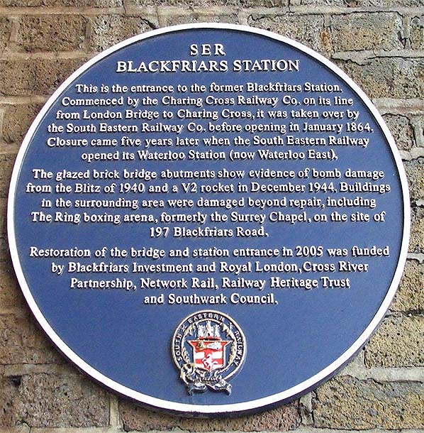
Blue plaque in December 2008
Photo
by Nick Catford
5.jpg)
6.jpg)
Blackfriars Road bridge seen from the north side in April 2020. The widened viaduct for the north side platform (which was probably never built) is clearly seen
Photo by Sunil Prasannan 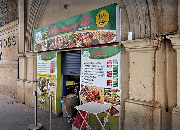 The Lebanese Grill which now occupies part of the Blackfriars station booking office.
Photo by Peter Kidd 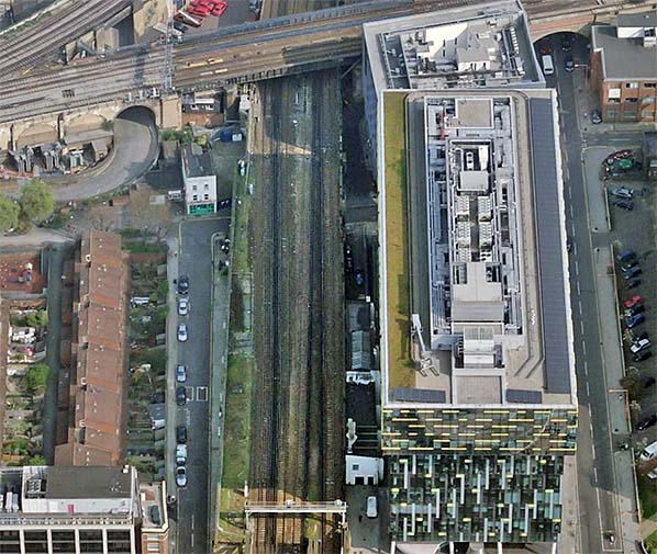
Recent aerial view of the site of Blackfriars station looking east.
|
 London Bridge was dropped from the title when the Charing Cross Railway Company was formed in 1859 in order to build the line, and the SER paid £300,000 in capital to help build it. The line towards Charing Cross was expensive to build as it traversed a heavily built-up area, which was exacerbated in February 1861 when the company chose to upgrade the two running lines to three, and doubled the capacity over the bridge to four tracks. The decision to upgrade the Hungerford river crossing to three lines was to cater for a proposed shuttle between Charing Cross and Canon Street on the north side of the line. The first Hungerford Bridge, designed by Isambard Kingdom Brunel, opened in 1845 as a suspension footbridge. It was named after the then Hungerford Market, because it went from the South Bank to Hungerford Market on the north side of the Thames. In 1859 the original bridge was bought by the Charing Cross Railway who replaced the suspension bridge with a structure designed by Sir John Hawkshaw.
 Blackfriars station was to be short lived. Within four years of opening the SER had already drawn up plans to replace Blackfriars with a new station to the west which would provide interchange facilities with the London & South Western Railway. On 27th March 1868 Lord Bury (William Coutts Keppel) who sat on the board of a number of railway companies, including the SER wrote “The South Eastern will erect a station at Waterloo and efficiently work it, and will charge the Charing Cross fares for the time being... and shut up Blackfriars. ”
  At street level the entrance door on Blackfriars Road survives as do two inscribed stone panels either side of the door. The panel to the north said ‘Charing Cross Railway’ and to the south Blackfriars Station’. For years these panels were partially obscured by advertising hoardings and the inscribed words had been filled in and painted over. In 2005 the bridge and station entrance were restored. This was funded by The Royal London Cross River Partnership, Network Rail, Railway Heritage Trust and Southwark Council. In July 2009 planning permission was granted for a cafe in the former station entrance at 200 Blackfriars Road. This is now known as the Lebanese Grill.
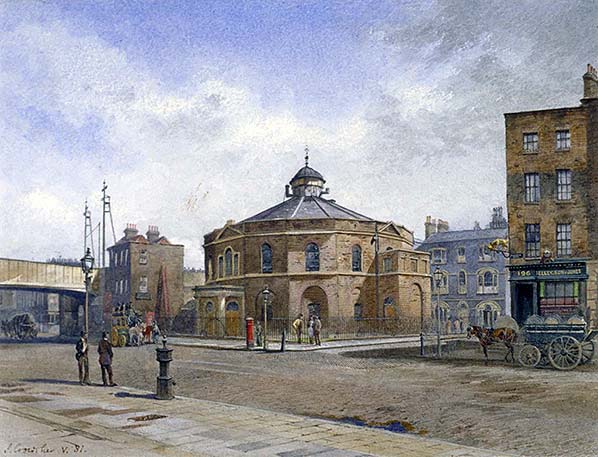
 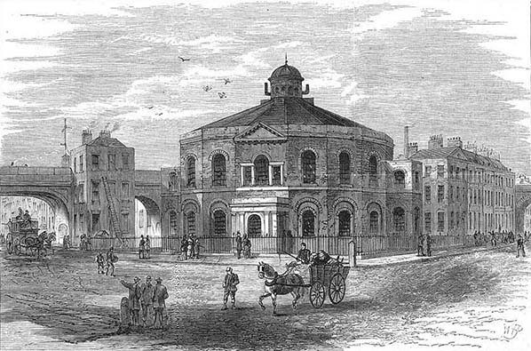 Wood engraving showing the Surrey Chapel at the junction of Blackfriars Road and Charlotte Street in 1881. Blackfriars Road bridge is to the left. The entrance to Blackfriars station is clearly visible under the bridge. The open arch to the east is a mystery as according to the engineers report prior to the station's construction described access to the station platforms was from stairs in the second and third arches. A doorway can be made out in the second arch which probably leads into the third arch. The building adjacent to the bridge appears to have pre-dated the railway; but it is possible it was incorporated into the station. The Bridge over Blackfriars Road was replaced to accommodate four tracks between 1907 - 1916. The bridge on the right is the LC&DR crossing over Charlotte Street; before passing over the SER. Click
 Home Page