
[Nick Catford]
Bentley Station Gallery 1: 1911 - 1930
old1.jpg) A 1911 view looking south at Bentley station and probably taken from the signal box. Whilst this is not the best of photographs it does provide a view of the Down side goods yard, the cartage sidings, as they were known, as well as the goods shed road behind the Up platform and the cattle pens (the white painted structure left of centre). Despite Bentley listed as being able to handle most types of goods, a notable exception being coal, it was not provided with a crane. The Hadleigh branch train stands in the bay platform, its Starting signal being the taller of the pair on the bracket. The shorter signal controlled exit from the cartage sidings. Given that the trap points, right foreground, which were standard installation, were provided with a ground signal (or points indicator) one wonders precisely what interlocking with the signals was provided at this time. Also visible is the Down side loading gauge, a second being located on the goods shed road.
Photo from James Lake collection 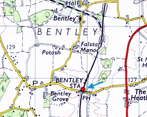 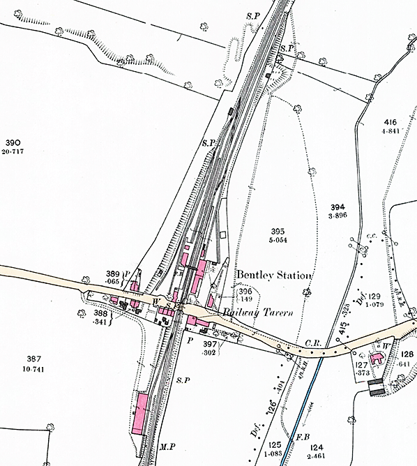
1892 1:2,500 OS map. This map clearly shows the complex layout of Bentley station with sidings on both sides of the line. The station was located on the north side of the Station Road level crossing with the Down platform and Bentley branch bay platform on the west side of the line and the Up platform on the east side. The main station building is on the Up side, and the large building also incorporates a goods shed at its north end. A smaller waiting room and the gents' toilet stand opposite on the Down platform. A footbridge spans the line between the two buildings. Two diverging cartage sidings are provided on the down side, running on the west side of the bay road. The siding on the Up side terminates at the north end of the goods shed while another siding runs diagonally south-east from this siding running past a small cattle pen. Two signal posts are shown on the down side and the signal box is shown but not identified at the north end of the cartage sidings alongside the bay road. The branch line continues north alongside the main line. The Railway Tavern is identified on the south side of the level crossing on the up side. South of the station Wilson's siding is seen on the Down side serving an unidentified Malthouse. Click here for a larger version.
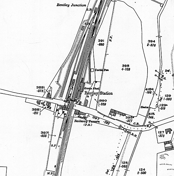
1904 1:2,500 OS map. Little has changed since the earlier map although the signal box, cattle pen, goods shed and Malthouse are now identified. The footbridge has been relocated closer to the level crossing and the down platform has been extended to the signal post. On the up side the junction with the siding has been moved further north and the platform also extended. Click here for a larger version.
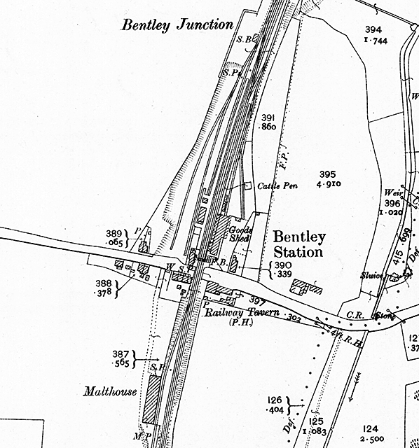
 1926 1: 2,500 OS map. A third parallel cartage siding has been provided on the down side running to the west of the signal box. The Malthouse to the south of the station has been removed and the siding partially lifted. The Up side building is more clearly defined, indicating which part is the goods shed. A canopy is shown over the shed's road vehicle bay.
old2.jpg)
Looking east along Station Road probably in the second decade of the 20th century. Railway staff cottages are seen to the right. In the left foreground is the entrance to the Down side goods yard, good sidings were provided on both side of the line with the goods shed being sited on the Up side. Note the very tall signal pole. Its height is for sighting purposes and this is described in more detail in the photo caption below.
Photo from John Mann collection old3.jpg)
Looking south along Bentley's Down platform, with the Hadleigh branch bay on the right. The period is believed to be shortly before WW1. The platforms, at least, are oil lit and would remain so for many more years despite the station being on a main line. The tall signals are of note especially the taller example with its lamp part way down the post; it is 'off' for an approaching Up train and its position on the Down side, as well as its height, is for sighting purposes as the station was on a curve. The signal beyond the level crossing is mounted on a tall post for the same reason. Note the running-in board on the left, announcing 'Junction for Hadleigh Branch'. The equivalent board on the Down platform provided no such information. The two-storey building to the left of the footbridge was the Railway Tavern, standing on the south side of Station Road. Bentley station master was not provided with domestic accommodation until 1864, seen here left background. This building also survives today. This view of the station is deceiving without careful examination, for the building on the Up platform is not what it seems. There were goods facilities on both Up and Down sides and the Up platform building closest the camera is in fact the goods shed. Close examination shows the canopy over the road vehicle bay at the extreme left of the building. The actual station building was between the goods shed and the level crossing but from this angle it is indistinguishable. Also on the left was a siding serving cattle pens but completely out of view here. The wagons on the right are on what was known as the cartage siding; in simple terms this was where cartage agents would load or unload goods to and from wagons with little or no involvement by railway staff. It was in effect a public siding. On the Down side of the railway and on the south side of Station Road stood maltings served by a siding accessed by points trailing in the Down direction. The points to this siding, known as Wilson's Siding, can just be discerned immediately beyond the level crossing.
Copyright photo from John Alsop collection old6.jpg)
Judging by the wagons in the cartage siding, right, this view almost certainly dates from the same time as the previous view. This time the photographer is positioned further north, thus offering a glimpse of Bentley's extended Down platform. The work was authorised in 1892 and presumably carried out immediately, taking the platform to a length of 550ft. The new section of platform in the foreground is at standard height but its mating with the original, lower, platform is somewhat ungainly. Surviving records are vague about whether the work involved both platforms; the Up platform appears to have a raised section but, if so, it is unclear when this was done. The new section of the Down platform has what appears to be ash infill between the flags, a common economy at one time. At the right are what appear to be stacks of sleepers. Perhaps the main lines had been relayed or, more likely, alterations to the sidings had occurred of which there were several down the years. Left of centre the loading gauge can be seen on the goods shed road which ran directly behind the Up platform. There were two cartage sidings on the right which merged before joining the bay road, actually the Hadleigh branch proper, and another loading gauge was located at that point.
old4.jpg)
The Railway Tavern pub on the north side of the level crossing at Bentley in 1915. The pub opened c1850 and was sometimes known as The Railway Hotel. Cobbold & Co is a local brewery. The company was founded at Harwich by Thomas Cobbold in 1723 moving to Ipswich in 1746. The company merged with Tollemache Breweries Ltd. in 1957 to form Tollemache & Cobbold Breweries Ltd. (aka Tolly Cobbold), owning 370 tied houses. The pub closed c1970 and is now a private residence.
Photo from James Lake collection old5.jpg) The level crossing, footbridge and gatekeeper' house seen from the south end of the Up platform circa first two decades of the 20th century. Railway cottages are seen beyond the crossing.
Photo from James Lake collection old7.jpg) Looking north at Bentley's Down platform sometime in 1930, two years before the Hadleigh branch closed to passengers. The branch train is seen in the bay platform, its two carriages no doubt being more than adequate for the business on offer. Both carriages date from the 1880s during Worsdell's tenure. The locomotive is reportedly a Class F3 2-4-2T. The Down platform now appears to have been raised to standard height throughout (see earlier photographs), while its modest accommodation and gentlemen’s lavatory, nearest the camera, can be seen. Note that unlike on the Up platform, the running-in board fails to announce that the station is the junction for Hadleigh. Further along the platform one of the oil lamps is receiving attention while at extreme right the signal box just comes into view. Among the advertisements are the then ubiquitous examples for Virol and Bovril plus one for the Daily Telegraph. Whilst such advertisements for newspapers were common, especially for The Times, the Daily Mirror and the now-defunct Daily Sketch, those for the Daily Telegraph were relatively uncommon on railway stations. Looking north at Bentley's Down platform sometime in 1930, two years before the Hadleigh branch closed to passengers. The branch train is seen in the bay platform, its two carriages no doubt being more than adequate for the business on offer. Both carriages date from the 1880s during Worsdell's tenure. The locomotive is reportedly a Class F3 2-4-2T. The Down platform now appears to have been raised to standard height throughout (see earlier photographs), while its modest accommodation and gentlemen’s lavatory, nearest the camera, can be seen. Note that unlike on the Up platform, the running-in board fails to announce that the station is the junction for Hadleigh. Further along the platform one of the oil lamps is receiving attention while at extreme right the signal box just comes into view. Among the advertisements are the then ubiquitous examples for Virol and Bovril plus one for the Daily Telegraph. Whilst such advertisements for newspapers were common, especially for The Times, the Daily Mirror and the now-defunct Daily Sketch, those for the Daily Telegraph were relatively uncommon on railway stations.Photo from James Lake collection Click here for Bentley Station Gallery 2:
|

 The main station building was on the Up side with a small forecourt. The building was of timber construction and comprised booking hall, combined booking office and stationmaster's office, waiting room, ladies' toilet and lamp room. The building abutted the irregularly shaped goods shed; 130ft in length and 39ft wide at the north end and 18ft wide at the south end. The two buildings shared an extravagant, over-sized hipped roof which also served as a platform canopy. There was also a canopy over the road vehicle loading dock at the front of the goods shed. A separate gents’ toilet stood to the north of the goods shed. On the Down platform there was a smaller building with a pitched roof and canopy comprising waiting room, ladies' toilet and a lock-up parcels store. There was a second gents' toilet block alongside. A footbridge spanned the line between the two buildings. Bentley station master was not provided with domestic accommodation until mid 19th century. The first house was of timber construction, suffered damp problems and was too small. After much bickering, a new house was rebuilt in 1864 at right angles to Station Road facing onto the short approach road.
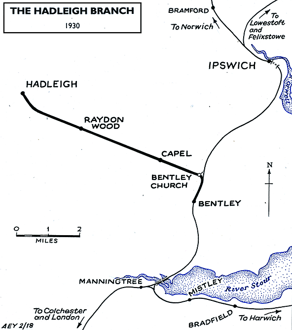
 Bentley station was around half a mile from the centre of the village it served but as was often the case a cluster of buildings grew up adjacent to the station. At the end of the Down platform was the gate keeper’s cottage and hut with two staff cottages on the opposite side of the road. In November 1874 complaints of overcrowding resulting in poor sanitary conditions were presented. The result was additional accommodation being constructed, adding to the small community growing up around the station.
 During 1916 the Great Eastern Railway ran poultry demonstration trains throughout East Anglia, often visiting towns on market day. The purpose of this train was to encourage self-sufficiency during the food shortages of the First World War. Encouraged by the reception this train got, in 1919 the GER purchased Dodnash Priory Farm, a mile south of the station, as a poultry demonstration farm. The hen houses were built at Stratford Works and had individual works numbers. By 1920 the farm was producing 40,000 eggs per month for the GER as well as chickens, turkeys, fruit and vegetables for the GER hotels, restaurants, dining cars and buffets. Dodnash Priory also served as a rest home for GER horses. A siding on the Down side accessed from points trailing in the Down direction served the farm. The siding was lifted in 1925 and the farm disposed of in 1927 when the farmer, by then aged 70, retired.
 Revenue earning goods services commenced on 1 June Revenue earning goods services commenced on 1 June 1846. On 4 June Major General Pasley visited the line to carry out the Board of Trade inspection, as approval was required to start passenger operation. Pasley was satisfied and a ceremonial opening took place on 11 June 1846. A train departed from Ipswich for Colchester, where it picked up a number of notaries, including George Hudson, chairman of the ECR, and Joseph Locke. On return to Ipswich lavish celebrations took place for all involved in the railway and in the evening a balloon ascent over the town was made by a famous balloonist, Charles Green.
 Home Page