Station Name: ALLT-Y-GRAIG

[Source: Paul Wright]


Date opened: 1.2.1929
Location: North side of Allt-y-Graig (road name)
Company on opening: London Midland & Scottish Railway
Date closed to passengers: 22.9.1930
Date closed completely: 22.9.1930
Company on closing: London Midland & Scottish Railway
Present state: Demolished
County: Denbighshire
OS Grid Ref: SJ058802
Date of visit: 18.11.2010

Notes: Allt-y-Graig was located on the 2½-mile long Prestatyn to Dyserth Branch. The line was opened in 1869 by the London & North Western Railway (LNWR) to carry lead and haematite from mines in the upper Prestatyn Valley down to the Chester and Holyhead Main line at Prestatyn.

Towards the end of the nineteenth century there was a demand for a passenger service on the line, with a petition being sent to the LNWR in 1896. The LNWR eventually agreed to this, and a regular passenger service started on Monday 28 August 1905. On 1 January 1923 the line became part of the London Midland & Scottish Railway (LMS).

Allt-y-Graig opened on 1 February 1929. It was located on the north side of a road overbridge and consisted of a simple, short low-level platform on the east side of the line. A sloping footpath and steps led up from the road. One of the main sources of passenger traffic was tourists who travelled up to Allt-y-Graig to view the Cwm waterfalls and a ruined castle.

Although in the early days the passenger service had been well patronised, by the time that Allt-y-Graig opened the railway had lost
passengers to a local motor bus service. The passenger service had been struggling financially for years, especially in the winter months. The opening of Allt-y-Graig had done nothing to improve the situation, and after being open for less than two years it was closed when the LMS withdrew all passenger services from the line on 22 September 1930.

The line reverted to being purely a freight route, and stone trains continued to pass through the site of Allt-y-Graig regularly until 7 September 1973.Even after 1973 trains occasionally passed through, but the traffic had ceased by 1980, and the track was lifted in that year. Attempts were made to reopen the line as a preserved railway, and, to this end, the local authority even bought the trackbed. Eventually the plans came to nothing, and the trackbed was developed into a footpath

Sources:

Further reading: The Prestatyn and Dyserth branch line by Stephen P. Goodall (Oakwood Press 1986) ISBN-13: 978-0853613138.
Other web site: www.dyserth.com web site for a feature on the Dyserth branch with more photos.
Click here to see a 4 minute film of a DMU railtour to the Dyserth branch in 1968.

Route map drawn by Alan Young

To see other stations on the Dyserth branch line click on the station name:
Chapel Street, Woodland Park, St. Melyd Gold Links, Meliden & Dyserth


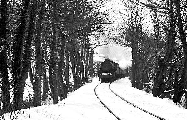
Ex LMS Class 5 4-6-0 45116 returns from Dyserth,and is seen approaching the site of Allt-y-Craig Halt on a snowy day, 5th March 1965, it was unusual for locomotives to work chimney first towards Prestatyn due to the gradients on this line; it being beneficial to assist in keeping keep the boiler water over the firebox crown by working chimney first; it is possible the turntable at Rhyl was inoperative due to the inclement weather.
Copyright photo by J.F.A.Hobbs


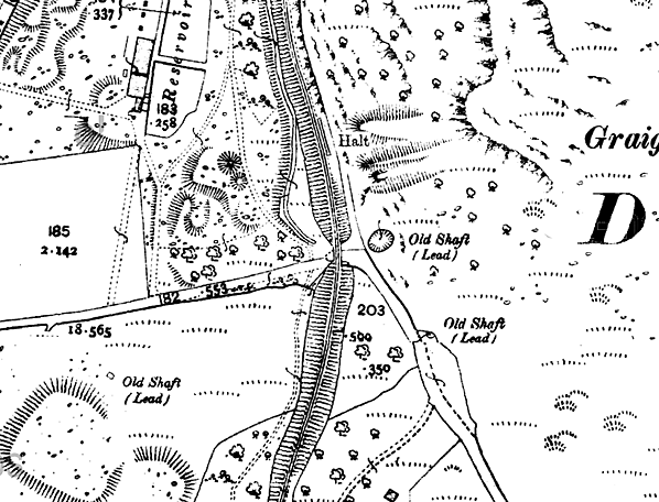
1912 1:2,500 OS map (with station added).


Looking north at the site of Alt-y-Graig in November 2010. The platform, which was short and low, was to the right of the picture.
P
hoto by Paul Wright

The slope that led up to Alt-y-Graig in November 2010. The slope is still in use as an access to what is now the Dyserth Railway path.
Photo by Paul Wright

Looking south at the site of Alt-y-Graig in November 2010.
P
hoto by Paul Wright

At Alt-y-Graig the Dyserth branch crossed the road by a bridge. The stopping place was to the right and was accessed via a sloping path. The path also passed under the line through the arch on the right.
Photo Paul Wright

Looking north-west towards Alt-y-graig from the road in November 2010. To the right there is a sloping path up to the track.
P
hoto Paul Wright

The access path to Alt-y-Graig in November 2010
Photo Paul Wright


[Source: Paul Wright]


Last updated: Friday, 12-May-2017 19:41:19 CEST
© 1998-2012 Disused Stations