
Station Name: ABERFAN[Source: Nick Catford]
Aberfan Station Gallery 1: c1908 - 1973
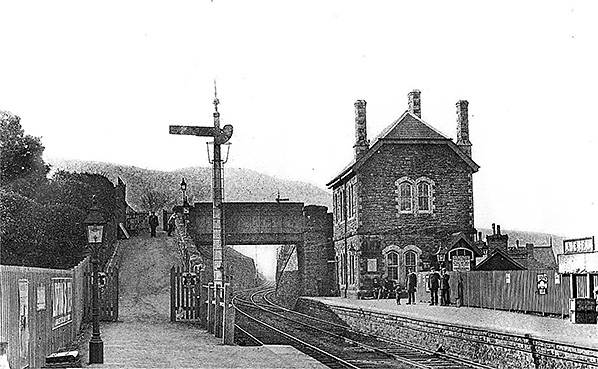
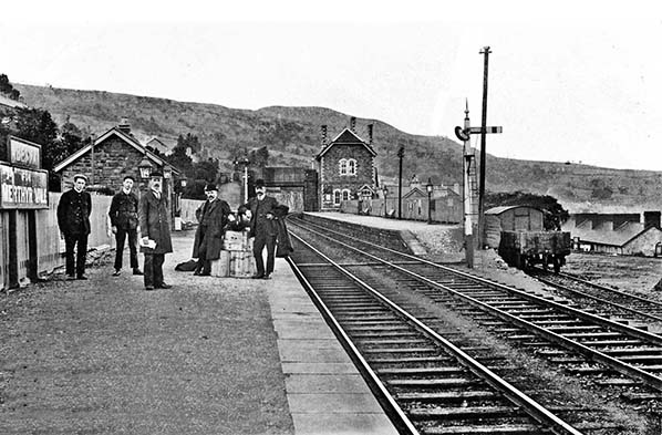 Aberfan station looking north west, this view being dated c.1908. This photograph comes with a 'spot the illusion' game. The telegraph pole on the right appears to be mounted behind the signal but passes in front of the signal arm. These signals are of the Rhymney Railway somersault type and what appears to be the pole passing the camera side of the signal arm is in fact the pivot point for the arm. Other photographs give the true picture perhaps better than words can describe. Note the flat-bottom rail in short lengths. This type of rail was standard on the Rhymney Railway until c. 1910 but much of it remained for many years subsequently and would only be replaced by bullhead rail when necessary. The station platforms, at least, are gas lit. The burners are inside glass domes which are themselves inside the lamp casements; this arrangement might seem a little elaborate today due to the familiarity of gas mantles but in the 19th century and into the early 20th century the arrangement was not uncommon. The local gasworks stood on the east side of Nixonville (a road name) and immediately south of Merthyr Vale Colliery. The site of the gasworks is now mostly covered by housing. To the right can be seen the northern end of Aberfan goods yard, most of which, including the goods shed, was a little further south. Photographs of railway stations from a century or more ago usually included a staff line-up and this has tended to become the butt of jokes due to the seemingly excessive number of staff. This view is therefore perhaps unusual in that only three obvious staff members are posing, with what was presumably the stationmaster nearest the camera. Who the two gentlemen with bowler hats were is not known. This views provides a good idea of the topography of the area. Apart from the obvious background hills note the houses on a higher level at extreme left and the houses at a much lower level at extreme right. This is, after all, the Vale of the River Taff.
Copyright photo from John Alsop collection 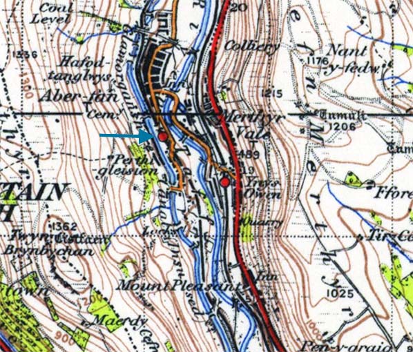 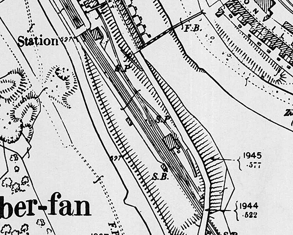
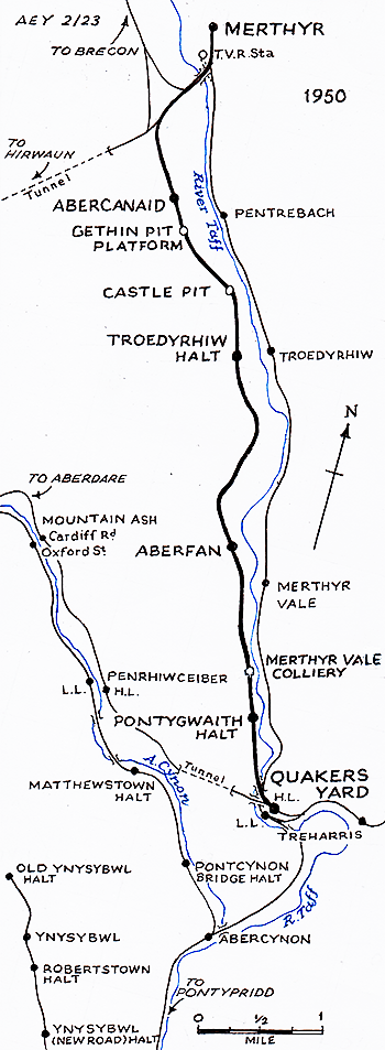
1899 1:2,500 OS map shows the layout of Aberfan station and goods yard as built. The station entrance is just visible adjacent to the bridge on the upper floor of the north west corner of the building. Passengers would go down stairs and out through an arch in the south east corner. A wide ramp leads to the down platform. A signal box south of the down platforms stands opposite the entrance to the goods yard. The yard comprises a loop with one side running through the goods shed and a short head shunt off one side of the loop. Beyond the loop, a long siding, probably for coal, runs diagonally across the yard to terminate north of the station building. From this siding a reversal gives access to another siding running under a canopy behind the good shed. Road access to the yard is along a steep drive up from Aberfan Crescent.
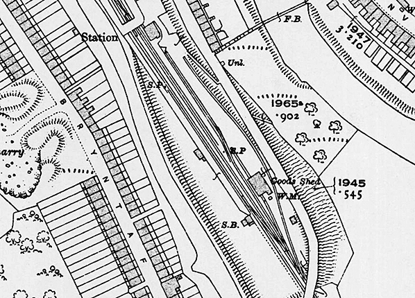
1916 1:2,500 OS map. By this date the yard had been partially relaid. The long coal siding has been shortened and realigned behind the up platform. The short head shunt from the loop has been removed and another siding has been added running behind the goods shed and along the east perimeter of the yard. The reversal from the coal siding has been removed. WM indicates a weighbridge and office.
 Aberfan station looking north west c1908. The addition to the 'For Merthyr Vale' suffix in 1902 saw the original running-in boards remain but with a second, larger, board added beneath them as seen here on the right. One might not unreasonably assume the lengthened name came about through competition with the nearby, very nearby in fact, Taff Vale Railway's Merthyr Vale station. It was something of a feature of the Welsh Valleys to find lines of different Pre-Grouping companies running more or less side by side and topography was no minor reason for this. In the era of coal mining and other heavy industries goods traffic would have sustained these lines for a time but passenger traffic was another matter. To discover why it is necessary to research the history of what were once very much self-contained, insular one might say, mining communities. On the west side of the railway and immediately behind the arched wall the long-defunct Glamorganshire Canal once ran. Only a small fragment of this canal remains watered but in Aberfan nothing especially obvious remains. The course of the canal can be followed by a footpath and it is not difficult to confuse this with the course of the former railway trackbed even though the two are on different levels. The exit from the booking office was through the arch in the south east corner of the building
Copyright photo from John Alsop collection
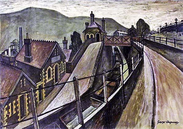 A dramatic painting of an empty coal train passing under the hairpin bend in Station Hill and into Aberfan station c1950. The station building stood at the bend in the road with the passenger entrance adjacent to the bridge. A dramatic painting of an empty coal train passing under the hairpin bend in Station Hill and into Aberfan station c1950. The station building stood at the bend in the road with the passenger entrance adjacent to the bridge.Painting by George Chapman (1908 - 1993). From Newport Museum and Art Gallery. 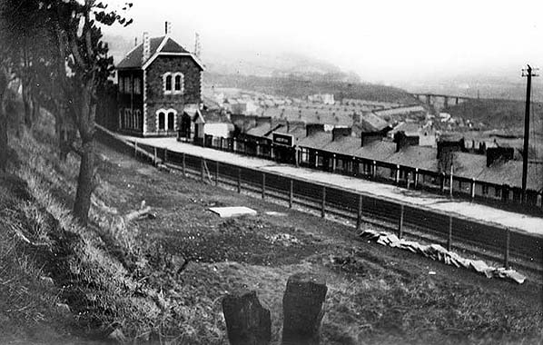 Looking north across the two platforms at Aberfan in 1954 after passenger traffic had ceased. Note that station name has reverted back to Aberfan. In the background a tramway over the River Taff takes spoil from Merthyr Vale Colliery. Within a few years this tramway would be extended past Pantglas Junior school to a new spoil tip in the hills above Aberfan. Looking north across the two platforms at Aberfan in 1954 after passenger traffic had ceased. Note that station name has reverted back to Aberfan. In the background a tramway over the River Taff takes spoil from Merthyr Vale Colliery. Within a few years this tramway would be extended past Pantglas Junior school to a new spoil tip in the hills above Aberfan.Photo from John Mann collection 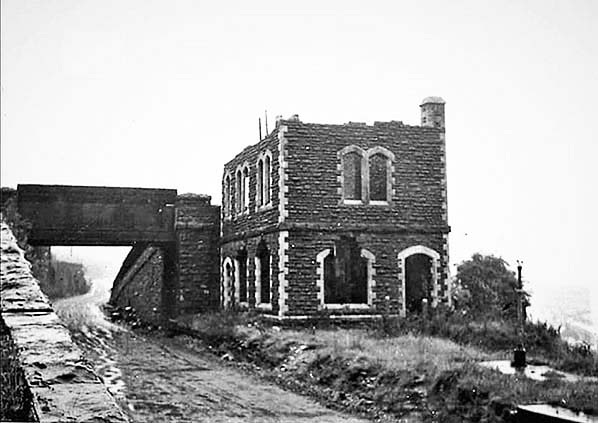 Aberfan station building on a wet day c1967. The building is now roofless and in a dilapidated state. During the 1960s it was a playground of local children and was even home to a homeless person for a while. The trackbed is being used as a road for removal of spoil following the Aberfan disaster of 1966 and would continue to be so used for some time thereafter.. Note the lamp standard still in place on the platform.
Photo from Jim Lake collection 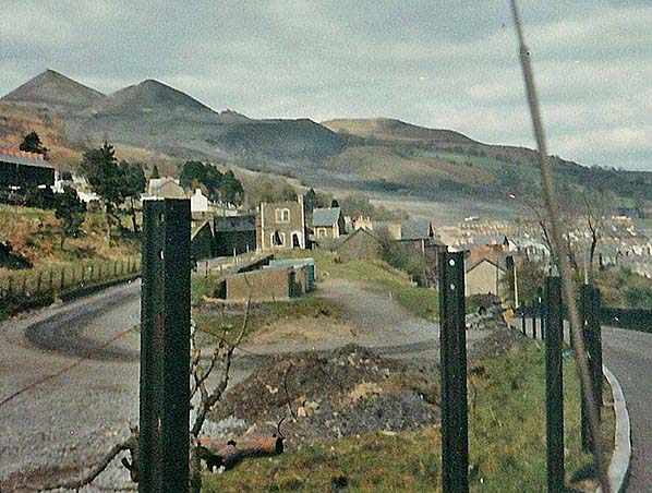 The remains of Aberfan station c. 1967. Most prominent are the posts made from lengths of redundant rail, the two nearest the camera, at least, are flat bottom rail and likely of Rhymney Railway origin, being surplus when the GWR relaid the line with bullhead rail. In the centre background platform remains are evident and the station house is in a derelict state awaiting demolition. In the centre of the picture, what the apparently concrete objects are is not known although they appear to be coal bunkers. They sit on what had been a goods dock, the location having been the northernmost end of Aberfan goods yard. The remains of No. 7 spoil tip, that involved with the disaster, can be seen centre distance and the trail of what was in effect a mudslide is discernible down the hillside. It should be mentioned for orientation purposes that north of Aberfan station the railway turned to run in a north-north-east direction before turning again to run due north. The school and houses at which so many lost their lives and the former railway, which at that point was on embankment, are therefore just out of view at the extreme right background of the picture. Subsequent to the disaster the remaining spoil tips, some of which are visible here, were removed but not until after much argument. The National Coal Board (NCB) argued against on the grounds of cost. In the end the task was paid for in part by the NCB and in part from the disaster fund, helped in no small part by one Margaret Thatcher, then Shadow Treasury Spokeswoman, who spoke out strongly in support of Aberfan. The spoil tips were on the hills between Aberfan and Mountain Ash, to the south-west, with spoil being transported from Merthyr Vale Colliery by means of a narrow gauge and largely cable-worked tramway. The tramway was known for many years of 'Nixon's Colliery Spoil Tramway', Nixon being the name of the colliery's founder. Merthyr Vale Colliery ceased operation on 25 August 1989.
Photo from Jonathan David Herron 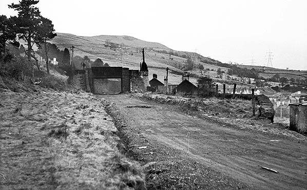 Aberfan station looking north west from the down platform in 1973. The station building was demolished c1968 with only the back wall remaining. The degraded platforms are still there as is the retaining wall and fencing at the rear of the up platform. The goods yard which was behind the wall was at a lower level. Aberfan station looking north west from the down platform in 1973. The station building was demolished c1968 with only the back wall remaining. The degraded platforms are still there as is the retaining wall and fencing at the rear of the up platform. The goods yard which was behind the wall was at a lower level.Photo by Nick Catford 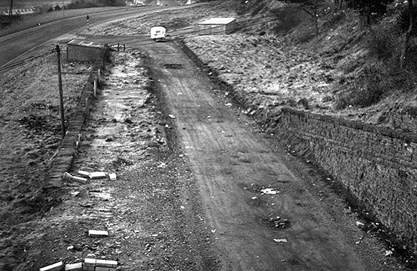
|
 A signal box stood at the south end of the up platform opposite the entrance to the goods yard which, as built, comprised a loop with one side running through a goods shed. There was a short head shunt at the south end of this side of the loop. From the loop, a long siding, probably used for coal, ran diagonally across the yard behind the down platform terminating at the north extremity of the yard beyond the station building. From this siding a reversal led to another siding running to the east of the goods shed under a short canopy. Somewhere in the yard there was a 1 ton 10cwt capacity yard crane but it isn't known where it was sited. The yard handled general goods and parcels but not livestock. Road access to the yard was along a steep track from Aberfan Crescent with a weighbridge and office being provided on the south side of the goods shed.
 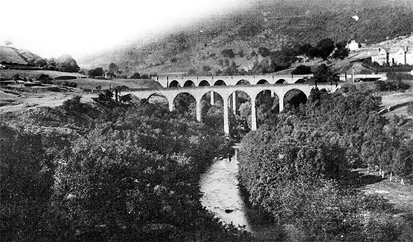 Quakers Yard viaducts No 2 (foreground) and No 3. From Quakers Yard station a line passed over the second viaduct before entering a tunnel to reach the Cynon Valley below Aberdare from where it ran on to Neath and Swansea. The Rhymney Railway later diverged from the Swansea line at Quakers Yard running along the west bank of the River Taff. This required the building of a third viaduct, parallel to the second but curving away northwards towards Merthyr from it. Both viaducts have now been demolished.
 The line opened for passenger traffic on 1 April 1886, trains using the High Street station at Merthyr. The new line crossed over the Taff Vale line and the Glamorganshire Canal shortly after leaving Quakers Yard GWR (later High Level) station. At nearly 2 miles south there was a branch on the east side to the Merthyr Vale group of coal pits, crossing the river on a long steel viaduct. Initially there were only two intermediate stations at Aberfan and Abercanaid, with the service being worked by the Rhymney company. At Cyfarthfa Level Crossing Junction, where the spur to the former Vale of Neath line ran round Glyndyris Pond, the private Gethin Railway ran straight on to the Cyfarthfa Ironworks, with a branch to the east running up to the Ynys Fach works, and. Rhymney goods trains and workmen's trains ran up to Cyfarthfa Furnace Tops.
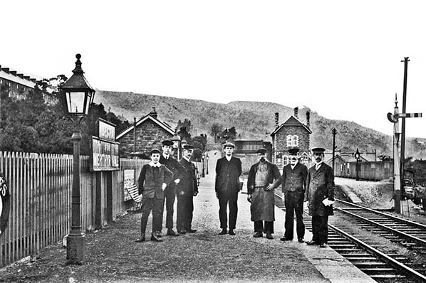 This image, also c1908, explains the 'signal illusion' mentioned in another caption. This time we are offered a rather better view of the staff line-up and it would appear certain of them, especially the stationmaster seen here farthest right, are present in other images. Stationmasters could remain at a particular station for many years but it was also not uncommon for them to be moved frequently, therefore it is not unreasonable to wonder if these three views along the northbound platform were taken at approximately the same time and perhaps within a few months of each other. The apparently immaculate white collars will be noted; in the days of steam locomotives and dirty air resulting from industry in general it must have been difficult to maintain a clean and tidy appearance but nevertheless that is exactly what these people did. Even the 'lower ranks' seen here were able to maintain smart collars and polished shoes. The exception is the gentleman wearing an apron but what his job was is difficult to say. The most likely explanation is he was a road vehicle driver, delivering goods arriving by train by means of a horse-drawn vehicle.
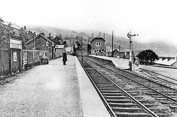 Aberfan station looking north west along the down platform c.1920s/30s; the running in board has now been replaced by a single board. The steeply graded goods yard is seen on the right ; vehicle access was from Aberfan Crescent, also seen on the right.
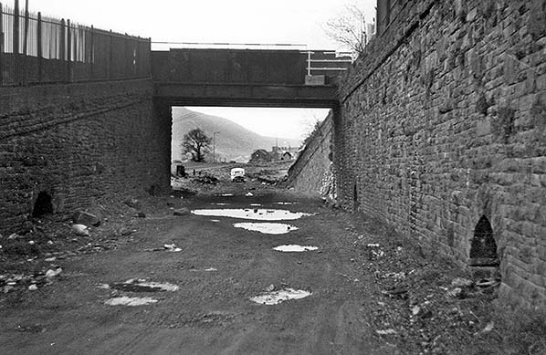 Looking south east towards Aberfan station in 1973.
 Home Page