Station Name: WARRINGTON BANK QUAY (1st)

[Source: Paul Wright]


Date opened: 4.7.1837
Location: South side of Bank Quay Bridge
Company on opening: Grand Junction Railway
Date closed to passengers: 16.11.1868
Date closed completely: 16.11.1868
Company on closing: London & North Western Railway
Present state: Demolished
County: Lancashire
OS Grid Ref: SJ599880
Date of visit: 21.4.2014

Notes: The first Warrington Bank Quay was situated on the Grand Junction Railway (GJR) which opened from Newton to Birmingham on 4 July 1837. The GJR was Britain’s first trunk railway and had been supported by many of the same individuals who had been behind the Liverpool & Manchester Railway (L&M). The GJR connected with the L&M at Newton Junction (which later became Earlestown Junction) thereby providing a link between Birmingham, Liverpool and Manchester. From 9 April 1838 the line connected with the London & Birmingham Railway (LBR) at Birmingham Curzon Street allowing passengers to travel between London, the Midlands and the great industrial and port cities of the north-west.

Warrington had been an important regional centre for centuries due to its strategic location as crossing point on the River Mersey; the bridge at Warrington was the most westerly road crossing until 1905. Because of its importance Warrington was provided with a substantial station on the western edge of the town. It was located on the south side of Bank Quay Bridge which passed over the line.

The station was reached by an approach road on the east side of the line. It led to a large two-storey building that faced directly east. Behind the building there were three platforms.

The station had sidings to the south, east of the line, and on the north side of the Bank Quay Bridge there were extensive goods facilities on the east side of the line. On the west side of the line opposite the goods facilities was a six-road engine shed.

In the early years Warrington Bank Quay would have been served by trains running to Birmingham Curzon Street, Liverpool Lime Street, Manchester Liverpool Road and Wigan. There would have also been through coaches to London (via the LBR) and to Bolton.

On 16 July 1846 Preston Brook became part of the London & North Western Railway (LNWR). By this time the station was on a route that stretched from London to Carlisle.

The March 1850 timetable showed 8 up and 9 down trains Monday-to-Saturday. There were 4 trains in each direction on Sundays. Destinations served included Birmingham, Carlisle, Crewe, Glasgow, Liverpool and London.

On 1 May 1854 the St Helens Canal & Railway Company (SHC&RC) opened an extension to its line from Garston into the centre of Warrington. The line passed under the former GJR a short distance south of Bank Quay station. It made an end-on connection with the Warrington & Stockport (W&S) Railway at Warrington Arpley where both companies shared a station. The LNWR took over the W&S on the xxx 186x and the SHC&RC on xxx 1864. The LNWR did not wish to have two stations in the town and wanted to make interchange between the two lines easier. The solution was to build a new station at the point where the two lines crossed on two levels. The new station was also called Warrington Bank Quay and it opened 16 November 1868. The original station closed on the same day.

After closure the original Bank Quay station was demolished and its site was used for sidings. The station building survived as offices until the middle of the twentieth century but by 2014 the area on which it stood had become a retail store.

Tickets from Michael Stewart route map by Alan Young.

Sources:

  • Britains First Trunk Line - The Grand Junction Railway - Norman W Webster - Adams & Dart 1972
  • Railway Passenger Stations in Great Britain - A Chronology - Michael Quick - RCHS 2009

To see other stations on the Grand Junction Railway between Earlestown and Crewe click on the station name: Vulcan Halt, Winwick Quay, Warrington Dallam Lane, Moore, Preston Brook, Minshull Vernon and Coppenhall

The 8D Association - Dedicated to promoting the history of South Lancashire and North Cheshire railways. Web Site


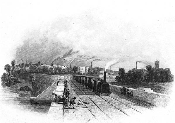
Looking north towards Warrington in 1839 from the bridge that carried the GJR over the River Mersey. The station is out of sight in the distance but the town of Warrington can be seen on the horizon.


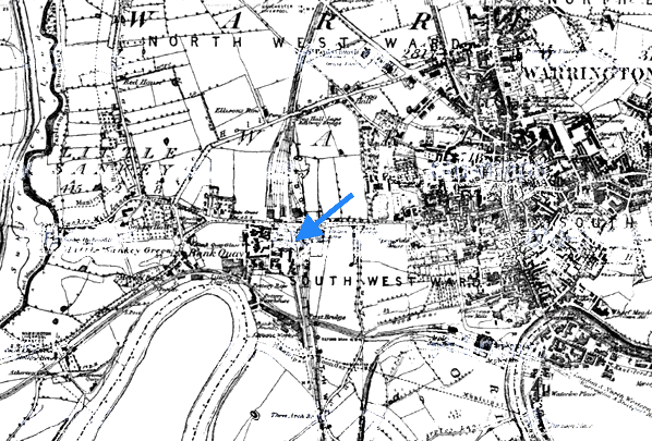
As an important regional centre the Grand Junction Railway provided extensive railway facilities at Warrington from the start. This map from the early 1850s shows the passenger station and the goods and servicing facilities that lay to the north.

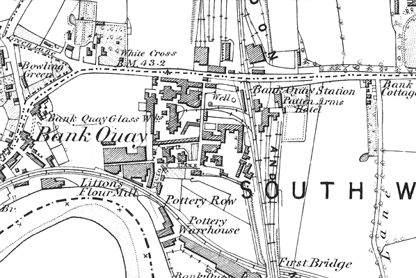
The first Warrington Bank Quay station shown on a town plan from the early 1850s.

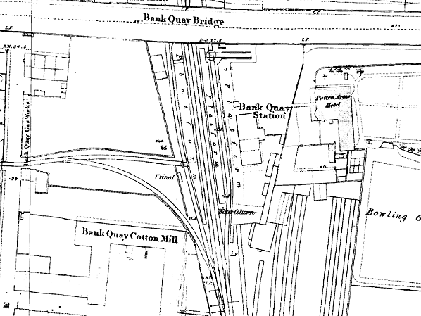
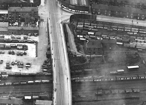
An aerial view of the site of the first Warrington Bank Quay station taken in 1920. The station had been to the right of the bridge where a passenger train can be seen. The house like building surrounded by railway tracks had been the Patten Arms hotel and had existed at the time of the station. It can be seen on the town plan above. The access road to the first station can also be seen to the left of the Patten Arms. Hotel.Nothing survived of the station as the land had been utilised for extra sidings and tracks.
Reproduced with the kind permission of Simmons Aerofilms Ltd


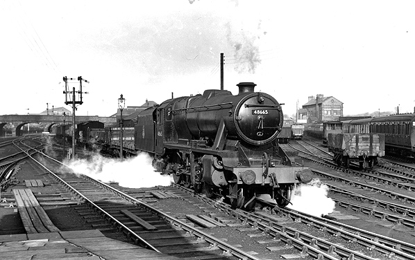
A view looking north towards the site of the first Warrington Bank Quay station from the north end of the second station on 17 October 1953. The station was located adjacent to the bridge that can be seen in the distance. Passing through the first station site is a mixed goods train hauled by ex-LMS 2-8-0 8F locomotive number 48665.
Photo by John Kirwood

The site of the first Warrington Bank Quay station looking south on 21 April 2012. The station was in the foregroundand would have extended no further than the locomotive that is seen heading north on a ballast train. In the distance can be seen the second Warrington Bank Quay station.
Photo by Paul Wright


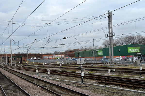
Looking north at the site of the first Warrington Bank Quay station on 18 February 2015.
Photo by Terry Callaghan


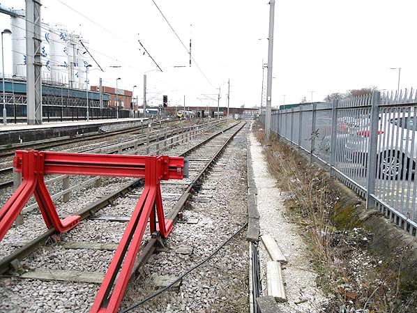
A view looking north towards the site of the first Warrington Bank Quay station on 14 March 2015.
Photo by John Wilson
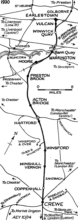


[Source: Paul Wright]


Last updated: Friday, 26-May-2017 09:55:05 CEST
© 2004-2015 Disused Stations