|
Notes: The first St Helens station was the northern passenger terminus of the St Helens & Runcorn Gap Railway (SH&RGR). The SH&RGR was promoted by a group of St Helens industrialists who were dissatisfied with the Sankey Canal as a means of transporting goods, in particular coal, to the River Mersey for onward shipment. The canal was the first of the industrial age in England opening in 1757. Although it had changed the fortunes of St Helens by the 1820s it was considered to be too slow. Also during periods of extreme cold or drought it could not be used. In 1829, as construction of the Liverpool & Manchester Railway (L&M) was underway, the industrialists arranged for a survey to be carried out for a line between St Helens and the River Mersey at Runcorn Gap (later to become Widnes). The survey was carried out by Charles Blackner Vignoles who had previously undertaken work on the L & M.
 A route was determined and an estimated cost of £119,980 to build the line was put forward. In January 1830 a prospectus was issued and a subscription list for 1,200 shares at £100 was opened at the Fleece Inn in St Helens. Peter Greenall of a large local brewing company was elected Chairman of a Board of ten directors. The shares sold rapidly and, while all of this had been going, on authorisation for the line was being sought. A Bill for its construction was posted on 16 February 1830 and Royal Assent was granted on 29 May 1830; a connection to the L&M at Sutton was also authorised. A route was determined and an estimated cost of £119,980 to build the line was put forward. In January 1830 a prospectus was issued and a subscription list for 1,200 shares at £100 was opened at the Fleece Inn in St Helens. Peter Greenall of a large local brewing company was elected Chairman of a Board of ten directors. The shares sold rapidly and, while all of this had been going, on authorisation for the line was being sought. A Bill for its construction was posted on 16 February 1830 and Royal Assent was granted on 29 May 1830; a connection to the L&M at Sutton was also authorised.
On 15 June 1830 Vignoles was appointed as engineer to the project on an annual salary of £650 and works began. Various problems caused the work to progress slowly and costs overran but by xx, but by March 1832 the route between St Helens and the Liverpool & Manchester Railway was complete. The L&M had been a great success from its opening on 30 September 1830 as both a passenger and a freight railway. A passenger station was provided at Sutton - it became St Helens Junction - and it was not long before the residents of St Helens were asking for a connecting service over the SH&RGR.
From September 1832 a horse-drawn carriage was operated between St Helens and St Helens junction along the SH&RGR. It was privately operated and the railway was paid 25% of the takings. It is not known exactly where the service operated from at St Helens, but it is likely to have been from Peasley Cross Lane - later to become the Warrington Old Road - as this was the nearest point to the town. On 28 November 1832 a train carrying coal was able to pass along the entire length of the line from St Helens to Runcorn Gap. Final works were completed and the line was officially opened on 21 February 1833. Further lobbying took place, this time for a passenger service to Runcorn Gap.
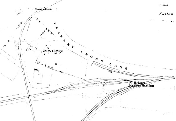
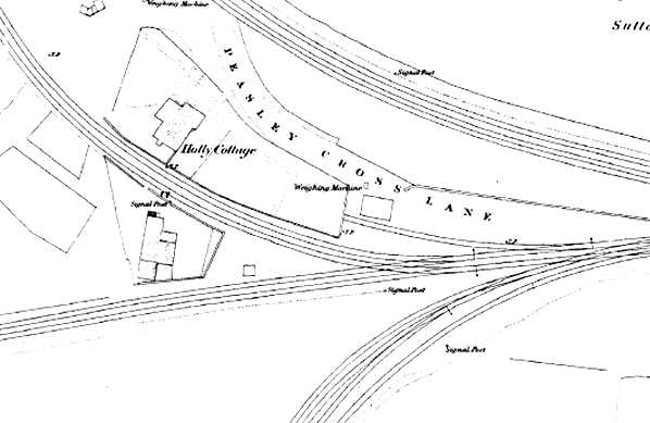
In September 1833 the SH&RGR hired two coaches from the L&M at £1 0s 0d per coach per week. They used them to introduce a passenger service between St Helens and Runcorn Gap by attaching them to goods trains. The company clearly did not place much value in its passenger business! A passenger station would have been created by this time although it is likely to have been very basic. It was located at the southern end of Peasley Cross Lane. A map from the 1850s (drawn after it was closed) shows a small building equipped with a weighing machine.
 Interestingly some services down to St Helens Junction were still horse-drawn in 1835 as Sir George Head in his Book A Home Tour Through the Manufacturing Districts of England in the Summer of 1835 explained how 'we all got into one large covered vehicle, and were dragged at a foot pace, by a single horse, along the branch railroad, about a mile in length, that leads to the town…it must be confessed that the present mode of conveyance was as disagreeable and slow as can well be imagined'. It is not known when the last horse-drawn services operated. Interestingly some services down to St Helens Junction were still horse-drawn in 1835 as Sir George Head in his Book A Home Tour Through the Manufacturing Districts of England in the Summer of 1835 explained how 'we all got into one large covered vehicle, and were dragged at a foot pace, by a single horse, along the branch railroad, about a mile in length, that leads to the town…it must be confessed that the present mode of conveyance was as disagreeable and slow as can well be imagined'. It is not known when the last horse-drawn services operated.
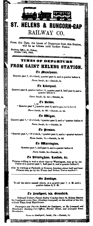
In 1838 over 26,000 passengers used the line. Very little thought was given to them: the SH&RGR did not so much as submit a timetable for the Bradshaw publication which began in 1839. Journeys between St Helens and Runcorn Gap were very slow due to the line having two inclined planes, one at Sutton and the other a mile to the north of Runcorn Gap.
The SH&RGR struggled financially in the early years owing to a price war with the Sankey Canal Navigation Company. The Sankey Canal had been extended to Runcorn Gap in July 1833 so that it could compete with the railway. The price war had a negative effect on both companies, but they reached an accord and merged as the St Helens Canal & Railway Company (SHC&RC) on 21 July 1845.
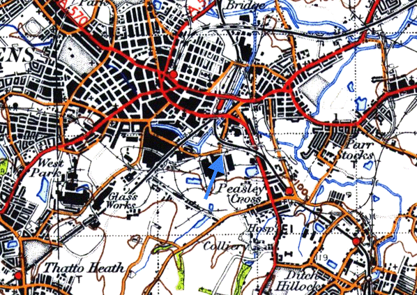
The merger of the canal and railway companies put both on a stronger financial footing. Plans were soon drawn up for extensions and improvements, which included making the original line double track and easing of the inclined planes so that locomotives could work throughout. One of the authorised improvements was the provision of a new St Helens station closer to the town centre. A new line of 21 ¾ chain was built which branched from the original to the east of the station at what became Ravenhead Junction.
The new line and station opened to passenger traffic on 18 December 1849 and the original station was closed.
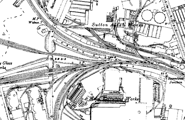
The original station continued to be used by goods services. It was still present in the 1850s but by the 1890s there had been an expansion in the number of sidings, and the station site had been lost under them.
The site of the original St Helens station remained in use as railway sidings until 11 July 1990. It was subsequently lost under road and retail developments.
Sources:
- Industrial Railways of St Helens, Widnes and Warrington - Part 2 St Helens Coalfield and the Sandfields - C H A Townley & J A Peden - Industrial Railway Society 2002
- The St Helens Railway, Its Rivals and Successors – J M Tolston – The Oakwood Press 1982
- The Widnes to St Helens Railway in Halton 1833 - 1982 - P T Wright - Halton Borough Council 2008
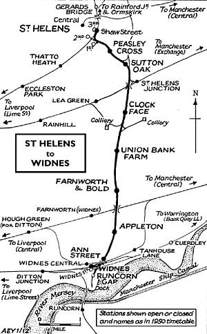
To see the other stations on Widnes - St. Helens line click on the station name: Runcorn Gap, Ann Street, Appleton, Farnworth & Bold, Union Bank Farm Halt, Sutton Oak, Peasley Cross, St Helens 2nd & St Helens 3rd
|

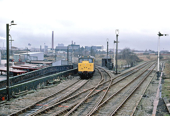
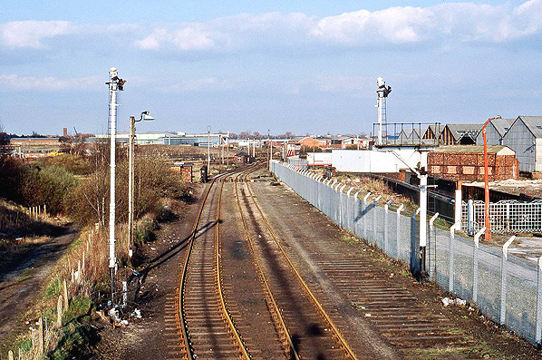 Looking east towards the site of the first St Helens station on 9 April 1988. The station was located in the middle distance. By this date the line at this point, which had become the Ravenhead branch, was in terminal decline.
1.jpg)
2.jpg)
3.jpg)
.jpg)
.jpg)
.jpg)
 Home Page