
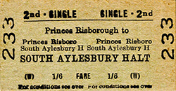
Station Name: SOUTH AYLESBURY HALT[Source: Nick Catford]
halt_old1.jpg)
South Aylesbury Halt looking north towards Aylesbury in June 1960. This is believed to show the station as built, no earlier photographs have so far come to light. Mandeville Road runs parallel with the line. The Concrete Utilities street lighting dates from the 1930s and provided sufficient light so no additional platform lights were necessary.
Copyright photo from Stations UK  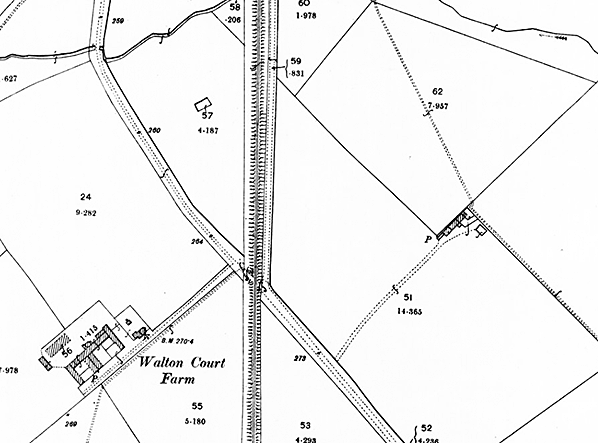
1899 1:2,500 OS map. This map shows the site of South Aylesbury Halt before there was any development of the area. At this time the crossing was a road crossing but by 1921 it had been closed to road traffic.
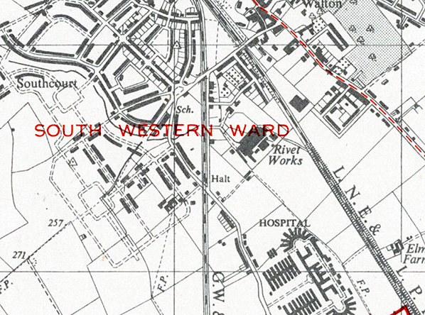
1949 1:25,00 OS map. This map shows the Southcourt residential development, the Bifurcated and Tubular Rivet Company works and Stoke Mandeville Hospital are seen. The halt was provided in 1933 to serve them. During the First World War the works manufactured rivets for soldiers’ boots and tyre studs, and during the Second World War the rivets were used in aircraft and bomb casings.
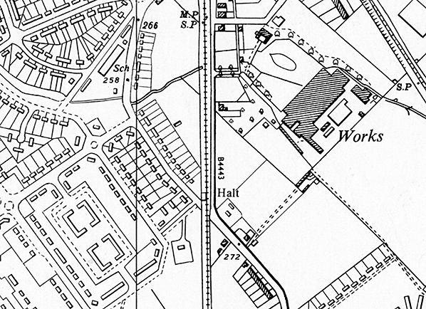
1969 1:10,000 OS map.
halt_old2.jpg) South Aylesbury Halt seen from Mandeville Road circa early 1960s.
Photo from John Mann collection halt_old3.jpg)
South Aylesbury Halt looking north towards Aylesbury circa early 1960s. Note one oil lamp at the end of the platform. The platform rasp was used for passenger access. From photographic evidence this was the only platform lighting ever provided the street lighting in Mandeville Road which dates from the 1930s was considered adequate to light the platform. The oil lamp was removed before the halt closed. Note the solid timber side walls of the shelter. Before closure windows were installed in both sides (see photo below) to provide additional lighting inside the shelter.
Photo from John Mann collection halt_old4.jpg)
On 31 May 1966, a year before closure, a diesel multiple-unit (DMU), apparently an 8-car formation, pulls away from South Aylesbury Halt and will shortly arrive at Aylesbury Town (once known as Aylesbury Joint), a mere three-quarters of a mile away. The headcode, 2B54, notwithstanding it being on the rear of the train, signified a Marylebone to Aylesbury via Princes Risborough service. Shuttles between Aylesbury Town and Princes Risborough carried the headcode 2B94. The DMUs are what came to be known as Class 115. Built at Derby, they were 4-car high density units with 4 x 230hp Leyland Albion engines per unit, making them somewhat more 'gutsy' than units fitted with the standard 150hp BUT (AEC/Leyland) engines. Albion was a Glasgow concern largely involved in the manufacture of commercial road vehicles, being taken over by Leyland in 1951 but the Albion name continued in use until 1972. Class 115, as it became, was operated in various areas of the country in the early years following its inception in 1960 and also during its final years which came to an end at Tyseley (Birmingham) in 1994. Otherwise Class 115 was intended for and spent the bulk of its working life on suburban services out of Marylebone and for that reason the class was known to rail enthusiasts and some railway staff as "Marylebone units". Until 1966 there were also some workings to Nottingham Victoria and return, most famously the 08:38 ex Marylebone (headcode 1D33) and 12:30 return (headcode 1B95). A number of cars, power and trailer, survive in preservation but as of 2021 only a couple of power cars are in running order. One final point of interest is that the Aylesbury - Princes Risborough line was destined to become the final haunt of what are now known as First Generation DMU's in public service on the National Network. The final pair, single unit railcars 55020 and 55034 (121020/34), finally bowed out on 19 May 2017. Both had, however, been refurbished and reinstated from departmental service. The original purpose of the halt was to serve the Southcourt housing estate, some houses of which can be seen in the left background. The line here was parallel with Mandeville Road, indicated here by the electric street lighting; this was considered adequate to illuminate the platform as no other lighting was provided in later years. The photographer is standing on the foot crossing over the line which gave access to the platform. The path connected Old Stoke Road with Mandeville Road and it is possible it was originally a level crossing for road traffic.
Photo by Bryan Jeyes halt_old5.jpg)
South Aylesbury Halt looking south on 31 May 1966. The oil lamp seen at the end of the platform in an earlier view has now gone. Some detail of the waiting shelter can be seen. The shelter has a wooden bench. The windows were fitted after 1960 but it is unclear if they were ever completed. One of the four may have had glass fitted.
Photo by Bryan Jeyes halt1.jpg) South Aylesbury Halt looking north along the platform in October 1967, a few months after closure. Mandeville Road is seen on the right. The bridge visible in the background carries Old Stoke Road over the railway and has itself become something of a saga. In the 1990s it was decided the bridge needed upgrading to carry increased weight of road traffic and a temporary bridge was erected. This temporary bridge and the 7.5 tonne weight restriction is still in place as of 2021.
Photo by Nick Catford halt2.jpg)
Looking north along Mandeville Road which ran parallel with the line as far as Old Stoke Road bridge. The street lighting provided adequate lighting so no additional lights were provided on the platform.
Photo
by Nick Catford
halt3.jpg)
The unusual two sided running-in board seen from Mandeville Road. The running-in board never carried the 'Halt' suffix.
Photo by Nick Catford halt4.jpg)
South Aylesbury Halt looking south in October 1967, a few months after closure.
Photo by Nick Catford halt5.jpg) South Aylesbury Halt looking north from the foot crossing linking Mandeville Road with Old Stoke Road.
Photo by Nick Catford halt6.jpg)
Looking north at the Mandeville Road / Old Stoke Road foot crossing and the site of South Aylesbury Halt c1969. After closure the halt was quickly demolished leaving no evidence that it ever existed.
Photo
from John Mann collection
halt7.jpg)
Looking along Mandeville Road towards the foot crossing and the site of South Aylesbury Halt c1969. After closure the halt was quickly demolished leaving no evidence that it ever existed.
Photo from John Mann collection halt8.jpg)
Looking north at the site of South Aylesbury Halt from the foot crossing linking Mandeville Road and Old Stoke Road in June 2006. The crossing was closed in 2017.
Photo by Nigel Cox. Reproduced from Geograph under creative commons licence
|
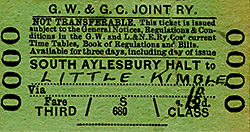
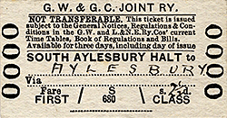 Notes: South Aylesbury halt was provided by the GWR in 1933 and while the 'halt' suffix appeared in timetables it is thought to have never appeared on the running-in board. The halt had a basic construction mostly using redundant sleepers with a clinker surface and in this respect was typical of many wayside halts. There was a wooden shelter with a bench which as built had solid sides (see 1960 photo) but in the 1960s windows were fitted to the sides presumably to provide more light inside the shelter. The running-in board was unusual for a single platform halt in that it bore the name on both sides. Presumably to advertise its presence to passing traffic on the adjacent and parallel Mandeville Road. Access was up the ramp at the south end of the platform from the foot crossing (formerly a level crossing) linking Mandeville Road with Old Stoke Road. At the south end of the platform there was a post-mounted oil lamp and this is the only known lighting to have been provided, early photographs of the halt being difficult to find. In later years the oil lamp had been removed but the adjacent street lighting will have provided some platform illumination and this was presumably considered adequate..
 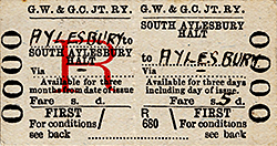 South Aylesbury halt had a decent number of services calling but the frequency was erratic with long gaps and a number of Saturdays Only and Excepted variations. It was likely for this reason that passenger volumes were never high, along with the proximity of the much better served Aylesbury Town station. In 1966, British Rail proposed the closure of the station which was queried by the East Midlands Transport Users Consultative Committee (TUCC) as usage figures showed that receipts were £130 per year while direct costs were only £26.British Rail subsequently justified the closure on the basis of anticipated renewal costs of £2,500 (a very familiar argument at the time) and the TUCC approved the closure, as there would be no hardship caused. The station closed on 5 June 1967 and was quickly demolished.. The irony is that although the area around the halt was still semi-rural in 1967 it is today very much built up, plus it now has a rather more convenient service pattern. Pedestrian access across the railway was maintained at the halt site until a fatality in November 2016 when a cyclist was killed. With a line speed of 40mph and 85 trains passing a day the crossing was closed in 2017 as the risk of further incidents was considered very high..
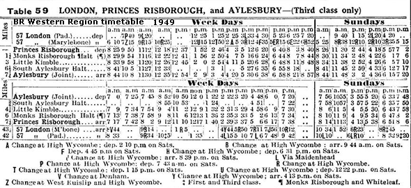
 In 1862, the Wycombe Railway opened an extension from High Wycombe via Princes Risborough to Thame. In 1863, it opened a single track broad gauge branch line from Princes Risborough to Aylesbury. In 1864, it opened an extension from Thame to Kennington Junction on the GWR line between Didcot and Oxford, thus finally completing its route to Oxford.
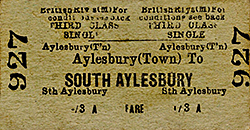

 Home Page