Notes: Robins Lane was situated on the St Helens Junction to Sutton Oak Junction fast lines which had been opened by the London & North Western Railway (LNWR) around 1883/4 (it was authorised as part of the 'LNWR New Railways Act of 1881'). The line connected the Liverpool & Manchester Railway of 1830 from St Helens Junction to the St Helens & Runcorn Gap Railway (Widnes and St Helens line) of 1832 at Sutton Oak Junction. There had been a connection between the two lines since 2 January 1832 when the first stage of the St Helens & Runcorn Gap had opened. The original connection branched off from Sutton Oak Junction and curved towards the east making a connection with the Liverpool and Manchester line. Passenger services had been carried over it from as early as September 1832, originally in the form of a horse-drawn coach.
 On 31 July 1864 the LNWR took over the St Helens & Runcorn Gap line. The railways in the St Helens area had become very busy by this time especially with the movement of vast tonnages of freight. There was also an intensive passenger service between St Helens and St Helens Junction, and the connecting line had become a bottleneck, causing delays. The solution was to build the new fast line connection. The new line diverged from the original connection just to the west of St Helens Junction. It then ran parallel to the original, but to its south, before passing under the Widnes and St Helens line after which it climbed up to meet it at Sutton Oak Junction on the western side. The new line passed over Robins Lane at a lower elevation than the Widnes line and the original St Helens Junction line. The line was designated as the fast lines for use by passenger services and through freight trains. The original route became the slow lines and was used by freight trains. Sutton Oak Junction had become a large and complex location and a new signal box was opened in November 1885 to control the traffic; it was replaced in 1932 with an LMS Type 11 timber structure with a 65-lever frame, making it the largest box on the line. On 31 July 1864 the LNWR took over the St Helens & Runcorn Gap line. The railways in the St Helens area had become very busy by this time especially with the movement of vast tonnages of freight. There was also an intensive passenger service between St Helens and St Helens Junction, and the connecting line had become a bottleneck, causing delays. The solution was to build the new fast line connection. The new line diverged from the original connection just to the west of St Helens Junction. It then ran parallel to the original, but to its south, before passing under the Widnes and St Helens line after which it climbed up to meet it at Sutton Oak Junction on the western side. The new line passed over Robins Lane at a lower elevation than the Widnes line and the original St Helens Junction line. The line was designated as the fast lines for use by passenger services and through freight trains. The original route became the slow lines and was used by freight trains. Sutton Oak Junction had become a large and complex location and a new signal box was opened in November 1885 to control the traffic; it was replaced in 1932 with an LMS Type 11 timber structure with a 65-lever frame, making it the largest box on the line.
By December 1895 there were 21 up and 24 down passenger trains using the fast lines between St Helens Junction and Sutton Oak Junction. By the early 1930s this had increased to 33 up and 29 down.
The LNWR had been absorbed into the London Midland & Scottish Railway (LMS) at the grouping of the railways on 1 January 1923. With such an frequent service between St Helens and St Helens Junction the LMS considered that it could gain extra revenue through the provision of a halt at Robins Lane which they opened on 12 October 1936.
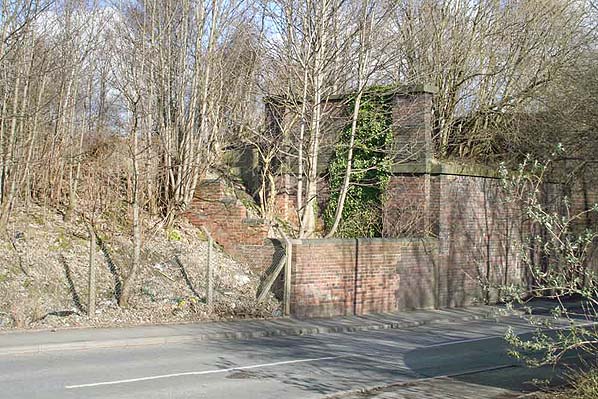
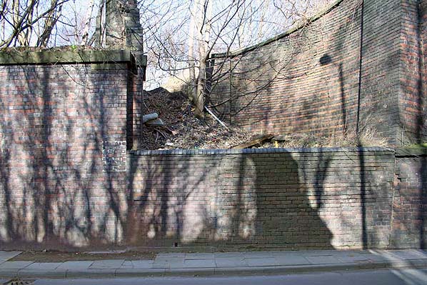
It was located on the north side of Robins Lane. Access was via gateways which were cut into the wall on either side of the St Helens Junction – Sutton Oak Junction fast lines bridge. No maps or photographs are known to exist of the halt, but a study of the topography in September 2012 determined that there must have been a set of steps between each access gate and platform. The platforms themselves were most likely constructed of timber and may have had simple waiting shelters. Painted onto the bridge abutment, adjacent to each gate, was information on which platform served which destination. The painted signs could still be seen in September 2012.
Robins Lane would have been served by trains running between St Helens and St Helens Junction. Some services continued or started from beyond the junction station from places such as Warrington Bank Quay or Earlestown. The service ran at roughly half hourly intervals in each direction and had already been nicknamed the ‘junction bus’ long before Robins Lane opened.
Robins Lane never generated the revenues that the LMS had anticipated and less than two years after it had opened it was closed on 26 September 1938.
Passenger trains continued to pass through the site of Robins Lane after it was closed. In the early 1960s, by which time the line was part of British Railways, most of them were provided by Diesel Multiple Units and there were 33 trains in each direction. Despite such an intensive service the Reshaping of British Railways report of 1963 (the’ Beeching’ report) recommended its withdrawal, which took place on 14 June 1965.
With the general decline in traffic, freight and passenger, by the second half of the 1960s there was no longer a need for fast and slow line connections between St Helens Junction and Sutton Oak Junction, and the fast lines of 1883/4 closed to all traffic on 2 March 1969. The bridge used by these lines to cross Robins Lane was removed but the brick abutments were still present in 2012.
The Widnes line closed as a through route on 1 November 1981, the section between Sutton Oak Junction and Clock Face remaining open to serve Sutton Manor Colliery. It saw its last train on 15 August 1987 and was taken out of use on 10 October 1987. The line between St Helens Junction and a point just to the north of Sutton Oak Junction closed on 27 May 1989 and was lifted shortly after.
The 8D Association - Dedicated to promoting the history of South Lancashire and North Cheshire railways. Web Site
Sources:
- Industrial Railways of St Helens, Widnes and Warrington - Part 2 St Helens Coalfield and the Sandfields - C H A Townley & J A Peden - Industrial Railway Society 2002
- The St Helens Railway, Its Rivals and Successors – J M Tolston – The Oakwood Press 1982
- The Widnes to St Helens Railway in Halton 1833 - 1982 - P T Wright - Halton Borough Council 2008
To see the other stations on the St Helens Junction - St. Helens line click on the station name: Sutton Oak, Peasley Cross, St Helens (1st), St Helens (2nd)
& St Helens (3rd)
|

lane.jpg)
.jpg)
.jpg)


 Home Page