Notes: Londonderry Foyle Road was opened by the Londonderry & Enniskillen Railway (L&ER) on 18 April 1850. Located on the west bank of the River Foyle close to the historic centre of Derry/Londonderry the station was the northern terminus of the L&ER line. The line had opened to a temporary terminus (Londonderry Cow Market) that was not well situated on 19 April 1847. Foyle Road station was located adjacent to a bridge, built in 1790, which spanned the River Foyle and provided a link to the Waterside district.
At the time of opening the station had one platform that was enclosed by a relatively basic train shed.
Goods facilities were located to the south of the station on the west side of the line.
It took until 19 August 1854 for the L&ER to reach Enniskillen and it wasn’t until 15 February 1859 for a connection to be made through to Dublin.
From 1859 operation of trains on the L&ER line was undertaken by the Dundalk & Enniskillen Railway (D&ER) and from 1 January 1860 they leased the L&ER line. In 1862 the D&ER renamed themselves as the Irish North Western Railway (INWR). By this time Londonderry Foyle Road was connected to both Dublin and Belfast.
In 1862 an iceberg caused extensive damage to the Foyle Bridge that linked Derry/Londonderry to the eastern side of the River Foyle. A new bridge (the Carlisle Bridge) was constructed to replace it. The new bridge was a double deck structure and the lower deck of the bridge was provided with railway track and a connection was made to Foyle Road station.
The INWR carried out an extensive rebuild of Foyle Road station which was completed by April 1870. The rebuild included a new entrance building a large train shed and two platforms.
In 1876 the INWR merged with the Northern Railway of Ireland and the Ulster Railway to form the Great Northern Railway Ireland (GNRI). In 1883 they formally absorbed the L&ER company.
In 1887 the layout of the station was altered and the two seperate platforms were replaced with a single island platform that had two faces. The new platform extended further to the south than the originals. It was provided with a canopy.
In 1907 the 1870 train shed was replaced by a new structure.
In 1921 Ireland was partitioned into two separate countries, The Irish Free State and Northern Ireland. The county of Londonderry became part of Northern Ireland but the nearby county of Donegal became part of the Irish Free State. The GNRI became a railway company that was operating in two separate countries.
In April 1949 the railways of Northern Ireland were nationalised under the Ulster Transport Authority (UTA). As a large proportion of the GNRI network lay within a separate country (the Free State was renamed as the Republic of Ireland in 1949) it was not immediately nationalised. However because of financial difficulties in 1953 the company had to be taken into the joint ownership of the governments of Northern Ireland and the Republic of Ireland, and it was run as the GNRI Board. The board had a short life and at midnight on 30 September 1958 all of the GNRI lines in Northern Ireland were transferred to the UTA. All lines in the Republic of Ireland were transferred to Córas Iompair Éireann (CIÉ).
 By 1960 the UTA had closed many of the former GNRI lines in Northern Ireland and it turned its attention to the Derry Road. Although opposed by local authorities closure was eventually authorised and the last passenger train departed from Londonderry Foyle Road on Sunday 14 February 1965. By 1960 the UTA had closed many of the former GNRI lines in Northern Ireland and it turned its attention to the Derry Road. Although opposed by local authorities closure was eventually authorised and the last passenger train departed from Londonderry Foyle Road on Sunday 14 February 1965.
Track lifting was carried out in the late Autumn of 1965 and in 1971 Londonderry Foyle Road was demolished to make way for a road scheme.
CLICK HERE FOR A DETAILED HISTORY OF LONDONDERRY FOYLE ROAD STATION
Tickets from Michael Stewart. Timetables from Jim McBride and route map by Alan Young
Sources:
- Challoner, E Fairwell the Derry Road (Colourpoint, 2010)
- Johnson, S Johnson's Atlas & Gazetteer of The Railways of Ireland (Midland Publishing, 1997)
- Mahon, G Irish Railway Record Society Journals - 1954 to 1985 (Irish Railway Record Society)
- Patterson, E The Great Northern Railway Ireland (The Oakwood Press, 2003)
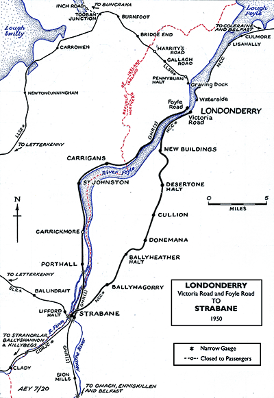
To see the other disused
stations on the Londonderry Foyle Road - Omagh line click on the station
name: Londonderry (Gallows Strand), Carrigans, St Johnston, Carrickmore, Porthall and Strabane (GNRI)
|

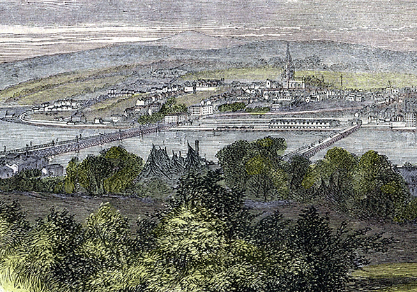 An illustration that shows Londonderry Foyle Road station from the Waterside district in the summer of 1863. The station can be seen on the far side of the River Foyle to the left of the 1790 bridge (right of view). The Carlisle Bridge which was completed in this year can be seen to the left of the station.
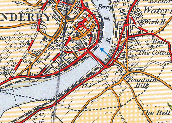
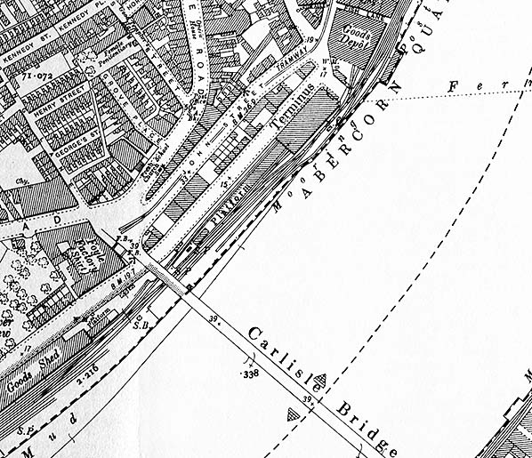 Londonderry Foyle Road station shown on a 25-inch scale map from 1905. The station occupies land on the west bank of the River Foyle. The passenger facilities can be seen to the north of the Carlisle Bridge and the goods facilities to the south. The large goods depot to the north of the station belong to the rival Midland Railway who had their terminus at Waterside on the other east side of the river.
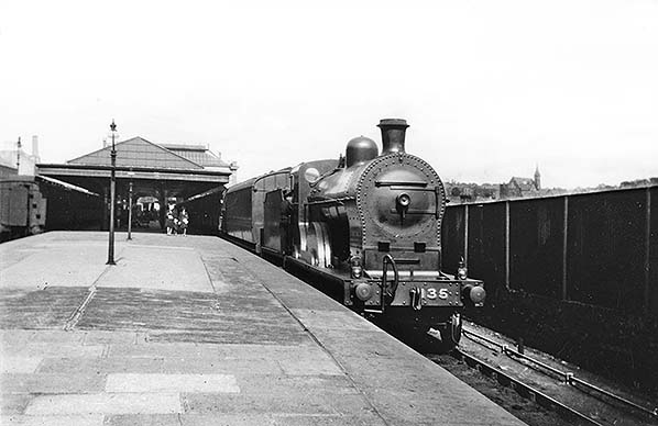
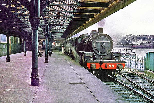 Londonderry Foyle Road station looking north on Saturday in July 1964. Waiting to depart on a local service to Strabane is ex-NCC W class 2-6-0 locomotive number 99 'King George VI'. The engine was withdrawn in May 1965. To the right the connection to the harbour commision lines can be seen but it had not been used for two years.
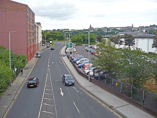 A view looking north-east at the site of Londonderry Foyle Road station on 7 July 2016. The view is looking along Foyle Road which was widened and partly realigned after the station was demolished. The station was to the right of the road where the car park can be seen.
 Home Page