Notes: Opened by the Knott End Railway (KER) on 29 July 1908 Knott End station was situated at the western end of the 11 mile 29 chain single track Garstang and Knott End branch line at the small coastal settlement from which it took its name. Knott End is located on the northern side of the River Wyre at the point where it joins the Irish Sea. On the southern side of the river is Fleetwood which in 1908 was an important port and fishing town that was also an attraction for tourists visiting the Fylde Coast. A ferry service was introduced between the two settlements in 1841 (which was taken into public ownership in 1893).
 A railway from the London & North Western Railway’s (LNWR) west coast trunk route, at Garstang & Catterall, had been opened to Pilling (4½ miles east of Knott End) by the Garstang & Knot (sic) End Railway (G&KER) on 5 December 1870. The line had struggled financially and had gone into receivership in 1878. It was never able to raise the capital to extend to Knot End. A railway from the London & North Western Railway’s (LNWR) west coast trunk route, at Garstang & Catterall, had been opened to Pilling (4½ miles east of Knott End) by the Garstang & Knot (sic) End Railway (G&KER) on 5 December 1870. The line had struggled financially and had gone into receivership in 1878. It was never able to raise the capital to extend to Knot End.
On 12 August 1898 the KER was formed to build the line from Pilling to Knott End. The new company also had financial difficulties as well as a legal dispute with its contractor and it took them 10 years to build the 4½ mile line. On 1 July 1908 the KER had purchased the G&KER route.
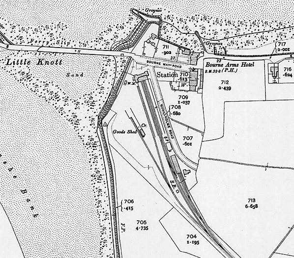
The station at Knott End was located on the east bank of the River Wyre close to the ferry landing point. It consisted of a single storey building which contained all of the usual facilities and two platforms. Goods facilities were provided in the form of two long sidings, a goods shed, a lifting crane, a weighing machine and a loading ramp. The goods facilities were located to the west of the passenger station.
 From the start the KER had seen the tourism of the Fylde Coast as an important source of traffic and during the summer months the operated an intensive train service which was promoted extensively. A further source of traffic for the line was the opening of a 1½ mile branch line from a point ¾ mile to the east of Knott End station to a salt works of the United Alkali Company at Preesall. From the start the KER had seen the tourism of the Fylde Coast as an important source of traffic and during the summer months the operated an intensive train service which was promoted extensively. A further source of traffic for the line was the opening of a 1½ mile branch line from a point ¾ mile to the east of Knott End station to a salt works of the United Alkali Company at Preesall.
A local company had been running motor bus services between Knott End and Pilling (one of the favoured visitor attractions of the area) since 1909 and as the buses went into the centre of the village they took many passengers away from the railway. In 1920 the KER hired a railmotor from the LNWR to supplement its summer services and to better compete with the buses. During the winter the railmotor started to operate all of the passenger services (click here to see the KER line on a quater inch scale map from 1920).
The July timetable for 1922 showed seven arrivals and departures Monday-to-Saturday.
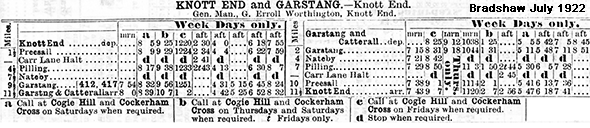
In 1922 the line was used by 77,579 passengers and it carried 69,535 tons of goods. The total revenue for that year was £12,815 against an expenditure of £11,583.
On 1 July 1923 the KER was absorbed into the London Midland & Scottish Railway (LMS). The LMS continued to use the railmotor for most of the passenger services.
During the 1920s competition from buses intensified and passenger services became uneconomic. On 31 March 1930 the LMS withdrew the passenger services from the line. Knott End station remained open for goods until 13 November 1950 by which time it had passed into the ownership of British Railways.
The line between Knott End and Pilling was lifted sometime after 1953.
The Knott End station building became a café after closure and was still performing that function in 2020 (albeit in a heavily modified form).
CLICK HERE FOR A DETAILED HISTORY OF KNOTT END STATION
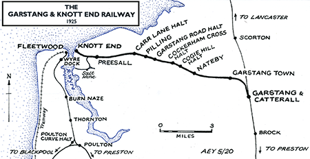
Route map by Alan Young
Sources:
- Awdry, C British railway companies (Guild Publishing,1990)
- Clinker, C R Clinker’s register of closed passenger stations and goods depots in England, Scotland and Wales 1830-1977 (Avon-Anglia,1978)
- Cobb, M H The Railways of Great Britain – vol.1 (Third Edition) (Author, 2015)
- Holt, G O A Regional History of the Railways of Great Britain – vol.10 (David & Charles, 1978)
- Quick, Michael Railway passenger stations in Great Britain - a chronology (RCHS, 2009 and on-line supplements)
- Richardson, D The Pilling Pig - A History of the Garstang and Knott End Railway (Cumbrian Railways Association, 2019)
To see the
other closed of the Knott End Branch
click on the station name: Garstang & Catterall, Garstang Town, Nateby, Cogie Hill, Cockerham Cross, Garstang Road, Pilling, Carr Lane and Preesall
Click here to see Register of Closed Railways 1901 - 1994 |

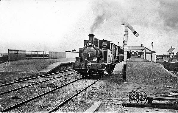 Knott End station looking north in shortly after it had opened in 1908. A train for Garstang & Catterall is seen departing from the station.
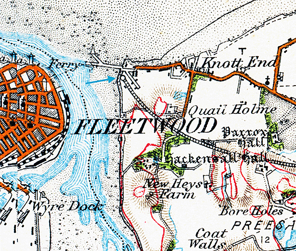
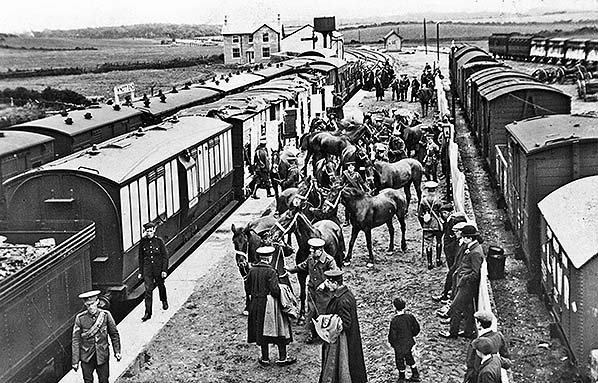 The military made use of Knott End station as their xxx camp was nearby. In this view from June 1909 horses are being unloaded from a train that is comprised of LNWR rolling stock. In the yard to the right gun limbers can be seen which would have also arrived by train.
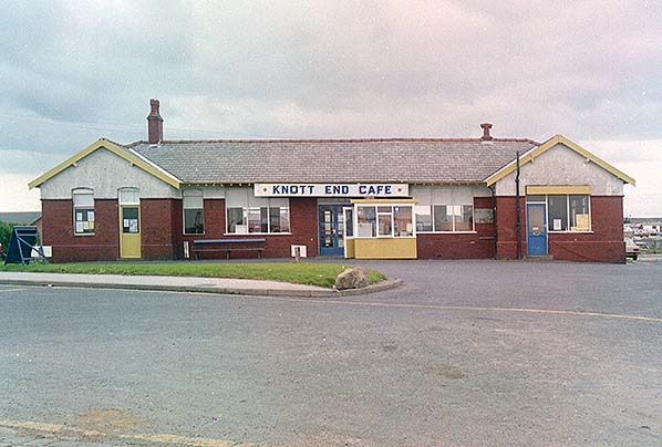 Looking south at the Knott End station building in September 1989.
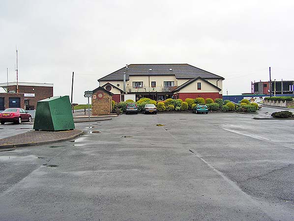 The site of Knott End station looking north on 29 May 2010.
 Home Page