|
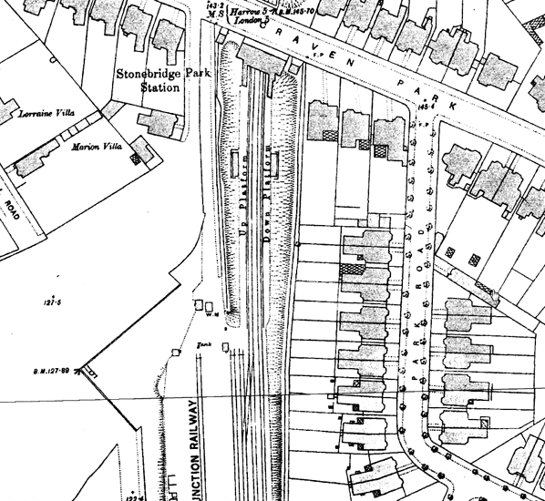
Notes: Harrow Road for Stonebridge Park and Willesden station opened on the 3rd August 1875. The station was sited in a cutting on the south side of Craven Park with a timber and slate entrance building incorporating the booking office. From the back of the building stairs led down to the two side platforms which were both provided with small timber waiting shelters.
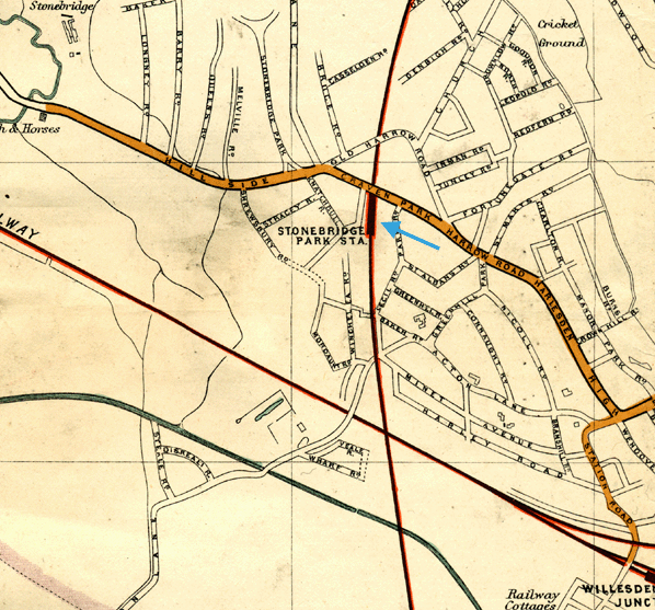
The station had a small goods yard with two sidings which was sited south of the station on the up side of the line. Access to the yard was controlled by a signal box which opened before 1875. This remained in use until 19th August 1890 when it was replaced by a new box on the down side of the line 10 chains south od the station,
 |
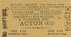
The stations name was changed on a number of occasions; on 1st February 1876 it became Harrow Road for Stonebridge Park & Harlesden and on 1st February 1876 it became Harrow Road (For Stonebridge Park and Harlesden). The suffix disappeared from 1st May 1878 only to return on 1st October 1879 as Harrow Road For Stonebridge and |
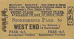
and Harlesden. It reverted to 'for Stonebridge Park & Harlesden' from 1st November 1880. Then the name was changed completely on 1st July 1884 to Stonebridge Park for West Willesden & Harlesden.
The station proved more popular than Dudding Hill with 7,838 tickets issued in 1876, rising to 20,991 in 1879 but tickets sale were then in decline dropping to 4,742 in 1887; the station closed the following year.
When the station reopened on 1st March 1893 there was an improvement in ticket sales remaining at around 20,000 a year until final closure. In a final attempt to attract more passengers the name was changed for one final time to Harlesden for West Willesden and Stonebridge Park on 1st February 1901 and that year proved to be the station's busiest with 27,744 tickets issued. This still wasn't sufficient however and the station closed for the final time on 1st October 1902.
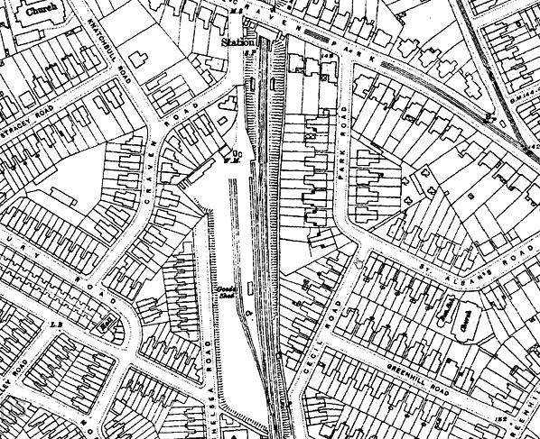
The two stairways were quickly removed but apart from that the station remained unaltered into the 1920s. The goods yard remained in use until 6th July 1964 with a private siding remaining in use after that date. The signal box closed on 31st October 1965 and was subsequently demolished.
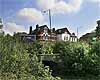
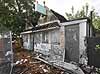
The street level building remained in use as a a secondhand shop for many years until it was finally demolished in the late 1960s. A small building alongside appears to be contemporary with the station (probably a coal office), this remained in retail use for many years but after falling derelict it was gutted by fire in 2010 and will presumably be demolished. Both platforms remained largely intact into the 1980s but now only the up platform remains
BRIEF HISTORY OF THE MIDLAND & SOUTH WESTERN JUNCTION RAILWAY
The Midland and South Western Junction Railway was authorised on 14 July 1864 and although it was an independent company it was worked by the Midland Railway from the outset with running powers also being given to the London & South Western Railway to Brent. (Confusingly, the similar name Midland and South Western Junction Railway was later used for a completely different railway in Gloucestershire, which was eventually taken over by the Great Western Railway.)
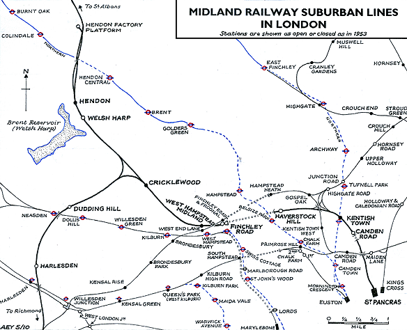 |
The line which is often referred to as the Dudding Hill loop line, ran through open countryside and was opened to goods traffic on 1 October 1868 from a north facing junction at Brent, south of Hendon to Acton Wells where it joined the North & South Western Junction Railway. This meant through running into St Pancras was initially not possible but as the line was intended as a goods and mineral link between the Midlands and the south of England this was not thought to be a disadvantage. Within a short while however, it was felt that a south-facing connection would be useful, so in 1871 powers were obtained to build the south facing Cricklewood Curve to a junction with the Midland north of Childs Hill station. The line was absorbed by the Midland Railway on 30 July 1874.
| With the opening of the Cricklewood curve it was now possible to run a passenger service from central London and stations were provided at Dudding Hill and Harrow Road opening on 3rd August 1875 with a circuitous service between Moorgate Street and Richmond. This service didn't prove popular and on 1st February 1876 it was replaced by a shuttle service |
 |
between Childs Hill & Cricklewood (now Cricklewood) and Harrow Road.
Ticket sales remained low with only 6,145 tickets issued at Dudding Hill in 1876 while at Harrow Road tickets sales were little better.
From 1st May 1878 a new through service was introduced from St Pancras to Earl’s Court on the Metropolitan District Railway; this immediately brought an increase in ticket sales. This new service formed the basis of the Midland Railway's Outer Circle, which ran from St Pancras to Earl's Court via Cricklewood, Acton and the District Line.
The popularity of the new service was, however, short lived as the fortunes of the passenger service once again went into decline. Through services were again withdrawn and the shuttle reinstated from 30th September 1880. There was a brief resurgence but then ticket sales plummeted to an all time low. In 1887 the total receipts for Dudding Hill stood at just £7. Although Harrow Road (now renamed Stonebridge Park) was doing better the line would clearly never make a profit and the passenger service was withdrawn completely from 1st July 1888 although he line remained open as an import freight route.
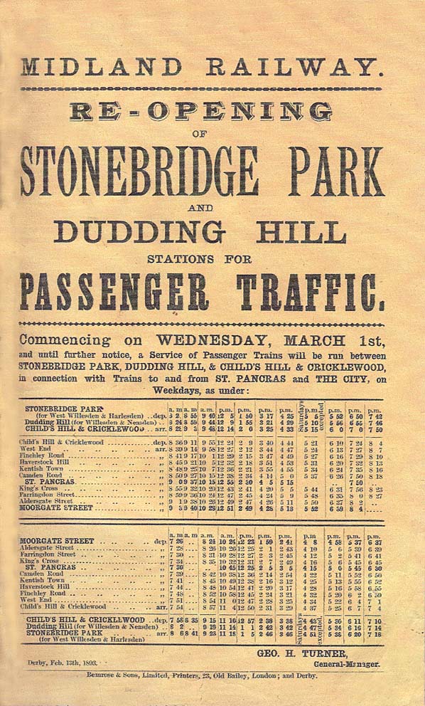
Five years later, the Midland Railway decided to have another attempt at running a passenger service and the two stations reopened on 1st March 1893. At first, the trains only ran between Child’s Hill and Stonebridge Park, but from 1st January 1894 they were extended southwards to Gunnersbury.
Although passenger numbers gradually began to improve towards the turn of the century the line was still considered to be uneconomic and the passenger service was withdrawn completely from 1st October 1902.
War-time traffic was particularly heavy. The Dudding Loop became an important freight route and southwest-to-northwest chords were later added to the West Coast Main Line at Harlesden and what is now called the Chiltern Main Line (originally the Great Central Railway) at Neasden.
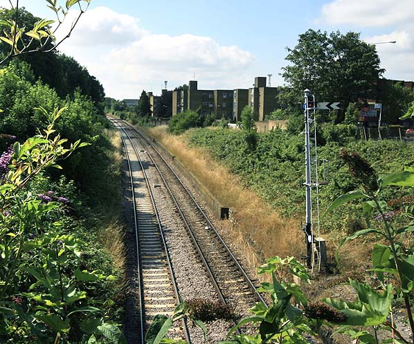
At present the line has not been electrified and has a 30 mph speed limit with semaphore signalling. It is lightly used for freight with a dozen trains a day in each direction. The main traffic is aggregates (including to a cement depot at Neasden) and compacted household waste from depots at Brent Cross and Dagenham to the land-fill site at Calvert in Buckinghamshire. The line is still authorised for passenger services and very occasionally, it is used for chartered passenger trains, including Pullman heritage coaches.
Sources:London's Disused Stations Volume 7 The Midland Railway by J E Connor. Published 2009 by Connor & Butler. ISBN 978 0 947699 42 2
Ticket from Michael Stewart, timetable from Glynn Waite, route map drawn by Alan Young
For other Midland Railway London suburban stations click on the station name: Hendon Factory Platform, Welsh Harp, Finchley Road, Haverstock Hill, Camden Road & Dudding Hill
| 
old1.jpg)
old2.jpg)
16.jpg)
7.jpg)
8.jpg)
4.jpg)
 Home Page
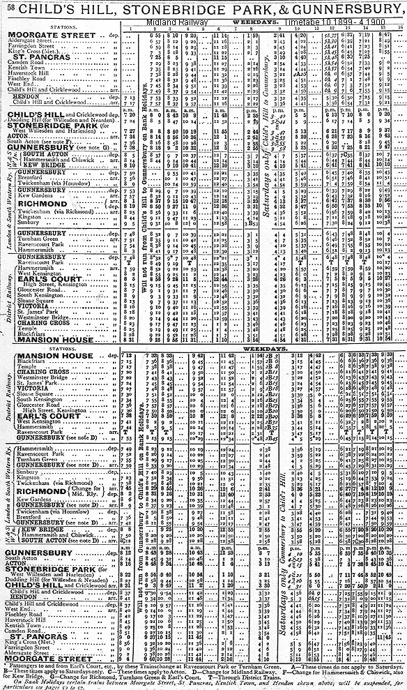
1.jpg)
thumb6.jpg)
thumb5.jpg)
thumb3.jpg)
thumb2.jpg)
thumb13.jpg)
thumb14.jpg)
thumb15.jpg)