Notes: Gilmerton station opened with the Loanhead line in August 1874 - the exact date of the opening of the line and the station is not recorded.
The earliest record of coal mining at Gilmerton was in 1627. By 1700 seams were worked to a depth of 48 ft, but by 1707 there was thought to be no workable coal left. In 1726 coal was once again being produced but mining remained sporadic. Fifty miners worked underground in the 1780s. After the 1823 strike there was no mining at Gilmerton from 1828 until the 1850s when small scale production was resumed.
When Edinburgh, Loanhead & Roslin railway was proposed the promoters were confident that their venture would help to develop the Lothian coalfield, and when the line opened a new mine was already under construction at Gilmerton on the down (west) side of the line.
The single platform at Gilmerton was on the down side. The single-storey stone-built stationmaster’s house was alongside Gilmerton Station Road. On the platform the station building consisted of two brick-built wings containing the booking office, toilets (initially ‘dry pan’ as the station had no running water) and a gents’ urinal, either side of a timber waiting room with a sloping roof. A grounded coach body was placed at the back of the platform adjacent to the building, but its purpose is unknown. There was also a small lamp room and a platelayers’ hut.
The station closed as a war time economy measure on 1 January 1917, reopening on 2 June 1919. During this period morning and evening workmen’s services continued to call at the station.
A signal box to the south of the platform controlled access to the small goods yard, which was also
on the down side to the south of the station. The yard comprised two sidings accessed from the north. Both of these served a goods dock, one end-on; a 3-ton crane stood on the dock. A connection from the goods yard served the colliery, involving a reversal, with sidings running behind the station building. Passengers had to walk across these sidings to reach the station.
| By 1908 the colliery employed only eight people, four of them working underground. Shortly afterwards it closed and the buildings were demolished. In 1928 the site was taken over by the Fordell Mains Colliery Co., and two new shafts were sunk to work seams at deeper levels. One of the shafts was on the original site but the main winding shaft and the pit head buildings were on the up side, opposite the station. At this time the original rail connection was removed, and new sidings were laid on the up side from a point south of the goods yard. Access to the sidings was controlled by a 4-lever ground frame which |
 Gilmerton Colliery
 |
also controlled catch points opposite the platform. A steel overbridge carrying a narrow gauge tramway connected both sides of the colliery to the north of the station.
Gilmerton was the quietest station on the line. Although the yard was equipped for handling livestock very little was ever dispatched. Large quantities of coal were handled at the station reaching a peak of 39,675 tons in 1896. By 1899 this had dropped to 1,224 tons and by 1909 only 327 tons, presumably all incoming as the colliery had closed. Other minerals peaked at 9,386 tons in 1887 dropping to 78 tons in 1931.
Passenger receipts steadily increased through the latter half of the 19th century. There were 4,760 passengers in 1880 rising to a peak of 17,676 in 1909. The following year the number dropped dramatically to just over 9,000 and never recovered. In 1921 the station handled 6,299 passengers and in 1932, the last full year before closure, there were only 3,022.
The station closed to passengers on 1 May 1933 but continued to handle goods traffic until 1 July 1959, with private sidings remaining open after that date. After closure of the colliery in 1961 its site was sold to scrap merchant Bernard Hunter, with two sidings retained for handling scrap traffic until 1978. Bernard Hunter Ltd still occupies the site. By 1976 the passenger platform and station building had been demolished.
BRIEF HISORY OF THE GLENCORSE BRANCH
There were a number of early schemes to bring a railway through the North Esk valley. One of the more ambitious projects was proposed by the Peebles Railway in November 1845 whose plan was to build a railway to Peebles from a junction with the Edinburgh & Dalkeith Railway south of Newcaighall. The route would have taken the line through Loanhead, Glencorse and Penicuik, with a branch to Lasswade and Roslin. For much of its route it would follow the course which would later be used by the Edinburgh Loanhead & Roslin Railway. The scheme failed to achieve any momentum, perhaps because of the steep gradients either side of the summit at Leadburn and the lack of potential goods traffic revenue, and it was abandoned before going before Parliament. A further ten years passed before Peebles received its railway which ran to the south of the earlier route, passing to the south of Penicuik, although an inconveniently sited station serving the town was opened on 4 July 1855.
In 1865 the North British Railway (Lasswade, &c. Branches) Act 1865 gave the company authority to build six lines (and two roads) between Edinburgh and the Peebles Railway which would have undoubtedly put some towns including Loanhead and Roslin on the railway map. The Act stipulated that all work must be completed within five years but construction never started, and the Act was allowed to lapse. Instead the NBR then encouraged local companies to put forward proposals which, if built, the NBR would offer to work for a proportion of the receipts.
One such company, the Edinburgh Loanhead & Roslin Railway, promoted a line from the North British Railway at Millerhill through Roslin to a terminus at Penicuik. After parliamentary notice had been given, another company, the Penicuik Railway, promoted a line from a junction with the Peebles Railway at Hawthornden, also terminating at Penicuik. Beyond Dalmore Mill at Auchendinny the two lines would follow the same route to Penicuik. The ELR offered a joint venture but this was declined, so the ELR cut their route back to Roslin with powers for a later extension. The Bill was unopposed and passed through Parliament on 20 June 1870. The NBR agreed to work the line for 30 years from the date of opening in return for 45 per cent of the gross revenue. They were also given powers to buy the line within five years of opening.
Although the ELR originally hoped to attract considerable revenue from the Shotts Iron Company’s recently opened ironstone mine at Mauricewood, the Penicuik Railway would be better placed geographically to handle this traffic. The ELR was confident that its venture would help open up the Lothian coalfield as mines were already under construction at Gilmerton, Loanhead and Dryden, and by means of short branches to mines at Straiton and Burdiehouse which promised to bring additional traffic to the line. The branch was also expected to generate a high volume of passenger traffic as the towns along the route developed as residential centres for professional people working in Edinburgh who needed to reach their workplaces in the city.
 |
As with both the Peebles and the Penicuik railways, eminent local railway engineer Thomas Bouch was employed to build the line. Bouch was at the zenith of his career, and with so many projects underway at the same time, one of his assistants, George Trimble was appointed to deal with the day to day work on the ELR. Construction started at Gilmerton in November |
1871, but progress was very slow due to heavy rain over a prolonged period. In August 1872 the NBR asked the board to proceed with the extension to Glencorse for which powers already existed. The North British Railway was keen that the extension should be built quickly to attract traffic from Mauricewood pit which was travelling by road.
The line should have been ready for mineral traffic during 1872 but bad weather continued to delay the work. A new estimate for opening the line in June 1873 was made, but only if weather remained favourable through the winter. The NBR continued to put pressure on the board over the Glencorse extension and threatened to take over the extension powers if the board continued to drag their feet. On 5 February the board finally agreed to put a Bill before Parliament for the extension; it received Royal Assent on 5 August 1872. The new Act authorised two lines: the first was an extension of the existing line to Glencorse for passenger and goods traffic (a distance of just under 2½ miles) and the second was from Glencorse to Penicuik only for goods traffic (a distance of just over 5 furlongs).
After protracted and difficult negotiations with the NBR over the junction at Millerhill, mineral traffic to Loanhead commenced on 6 November 1873 while work on passenger facilities continued. Due to pressure of work the Board of Trade was unable to carry out an inspection of the junction at Millerhill until 1 December 1873. The line was finally ready for a full inspection on 7 July 1874, and the Board of Trade inspection by Colonel Rich was arranged for 22 July. After some modifications to point-work the line opened to Roslin in early August 1874 (the exact date is not recorded) with intermediate stations at Gilmerton and Loanhead. The major engineering feature on the line was at Bilston Glen where the line crossed the deep, narrow, heavily wooded gorge of Bilston Burn by a slender lattice girder bridge designed by Thomas Bouch. It rested on five masonry piers, the tallest 134ft high.
Passenger and goods revenue rose steadily during the first year with 21,049 tickets sold at the three stations between February and July 1875. There were four daily trains in each direction. The first was the 8.35 am from Roslin (with a journey time to Edinburgh of 38 minutes) and the last returned to Roslin at 8.58 pm. This frequency was maintained until the opening of the Glencorse extension when one additional return trip was added.
It was hoped to have the extension to Glencorse open by April 1876, but this proved over-optimistic as work progressed very slowly, hampered once again by bad weather.
Before the extension was completed an agreement was made between the ELR board and the NBR for amalgamation. This was approved by Parliament, taking effect from 28 June 1877. By the second week in May the extension was ready for inspection. Major-General Hutchinson inspected the line for the Board of Trade on 16 May. Again the track-work came in for criticism but once modifications can been completed the ELR was authorised to open the extension on 2 July 1877, with the goods-only extension to Penicuik gas works opening later that year.
Additional passenger traffic came from the military base opposite Glencorse station. This was originally built to house prisoners from the Napoleonic Wars but, by the 1870s, it was disused. The coming of the railway brought a change of emphasis, with the establishment of a base for the Edinburgh County Militia, a form of Territorial Regiment.
The movement of the permanent staff from Dalkeith, where they had been based, to Glencorse on 19 March 1878 was the forerunner of many troop trains which would use the branch over the following 81 years.
By the late 1880s subsidence in the area of Bilston Glen was causing concern to local landowners, and the viaduct appeared to be settling slightly. Following concerns about the standard of work by Thomas Bouch following the collapse of Tay Bridge in 1879, with the loss of 75 lives, an investigation was authorised and carried out in 1890.
Although the nearest mine workings were 350yd away, an underground roadway had been driven to within 50yd of the viaduct. The engineer's report showed that the abutments had settled only slightly (the stonework could be retained with metal straps) and the brick piers had not moved at all, but the NBR still decided to replace the whole structure after only 18 years. They hoped to replace it with an embankment but this proposal was rejected, and instead they chose to construct a new viaduct consisting of a 300ft-long single span, 40ft deep with 55ft long lattice girders at each end. Two new piers were required, each consisting of a concrete base reinforced by old rails. The piers rested on firm sandstone, 20ft below ground level on the north side, 25ft on the south, while the outer ends of the side spans were to be supported by granite abutments.
Work started on 15 May 1892 with train services terminating at Loanhead. Services resumed over the new viaduct on 26 May. In the early part of 1897 the employees of the Shotts Iron Co. at Straiton petitioned for a platform for their use at the junction, to avoid the walk from Loanhead and Gilmerton. In their estimate dated 10 September the NBR stated that a wooden platform 6ft wide could be provided at a cost of £140, which appears to have been beyond the SIC’s budget, as there is no record of the platform being built. In July 1914 a bus service was started between Roslin and Edinburgh. Although the service was short-lived following the outbreak of war, it was clear that the convenience of buses could in time pose a threat to the railway. WW1 brought an increase in military traffic to the barracks at Glencorse, but wartime economy measures also saw the temporary closure of Gilmerton station which was the quietest on the line.
During the First World War the railways of Britain came under control of the government's Railways Operating Department, who had the power to order wartime economy measures. Owing to a shortage of manpower, one of these measures was the closure of many smaller stations. Gilmerton was one of these, losing its passenger service from 1 January 1917. Unlike some stations the closure was only temporary. There was an increase in military traffic to and from Glencorse Barracks. As the war progressed, more and more men were called to arms bringing increased revenue to the railway.
Whilst the 130 UK railway companies coped well during the war, there were calls for more consolidation and even for nationalisation. The government reached a compromise, and from 1 January 1923 all the companies were grouped into just four large companies, the ‘Big Four’. Under the ‘grouping’, the North British Railway became part of the London & North Eastern Railway.
Initially under the new ownership little changed, but by this time motor transport was making heavy inroads into railway traffic. Passenger numbers never recovered after the war and through the 1920s they were about half of the pre-1914 numbers, although Roslin still carried a large amount of summer excursion traffic.
The Big Four railway companies were quick to jump on the road transport bandwagon, and in time the LNER and the LMS owned a 50% share in the Scottish Motor Traction Co., although they were not permitted to run bus services themselves. Rather than integrate road and rail transport the LNER took the decision to close some loss-making lines including the Glencorse branch. With numerous bus routes radiating out of Edinburgh the railways stood no chance of competing. Gilmerton was served by 66 daily buses in each direction and Loanhead by 43.
Passenger receipts for 1932 were just £256 while the cost of running the service was £1,612. Closure was announced from 1 May 1933, and it passed almost un-noticed. Hardly any objections were lodged, and there was very little discussion about the closure. Very few people travelled on the final train. Special excursions continued to run from Loanhead after the withdrawal of regular passenger services from the branch.
All four stations continued to handle goods traffic, with the four remaining collieries (Roslin, Burghlee, Ramsey and Gilmerton) providing a good income for the northern end of line. In the 1930s additional traffic was generated at Loanhead when a new siding was provided into Mactaggart Scots factory for the shipment of seaplane catapults for the Royal Navy.
The railways came under minimal government control again during the Second World War, and there were renewed calls for nationalisation. The war once again brought an increase in troop trains to the barracks at Glencorse, and this traffic continued after the war as the base was used as a military hospital and rehabilitation centre for a number of years.
Nationalisation was one of the pledges of the Labour Party, who were swept to power in 1945. The coal industry came first on 1 January 1947 when the National Coal Board was formed, with the remaining four collieries coming under Scottish Division, Area No. 2. From 1 January 1948 almost all of the railways in the UK came under full government control as British Railways. Lines north of the border came under the auspices of British Railways, Scottish Region (ScR).
Coal remained the main source of fuel in the country, and branches such as Glencorse were still vital in transporting the output from collieries. The sinking of a mineshaft at a site in Bilston Glen to the south-west of Burghlee Colliery, which began in 1952, gave the line a new lease of life when full production started a decade later.
In 1955, British Railways published its Modernisation Plan. All areas of railway operation had been reviewed and decisions were made on the way forward, within the perceived wisdom of the time. Ever since the railways had started to carry freight, wagons had been collected and sorted in marshalling yards, which had originally been built to suit each railway company’s needs. This had resulted in a large number of small- and medium-sized yards scattered throughout the country, Edinburgh being no exception. Part of the plan called for new ‘hump’ marshalling yards, where wagons are shunted up a short steep ramp (or hump), and sorted by gravity, running into a fan of sidings. All movements are controlled from one control room, which operates the points remotely and works to a prepared plan. The area immediately to the north of Millerhill station was chosen as the site for such a yard to be known as ‘Millerhill New Yard’ serving the Edinburgh area, with 100 sorting sidings and the capacity to deal with 5,000 wagons per day.
In common with many other lines in Britain at this time, goods traffic on the Glencorse branch was falling to unacceptable levels, with the exception of that dealt with at Loanhead. The closure of Penicuik gasworks, in 1956, when the town was connected to a new main from Edinburgh, had removed the last regular traffic from the extension. The line was soon cut back to a point south of Glencorse station, leaving a headshunt to deal with troop trains. Goods services were withdrawn from Gilmerton, Roslin and Glencorse from Monday 31 August 1959, and the branch was closed beyond Roslin Colliery. Glencorse was served by military specials until 1959, and the last passenger train to call at the station was on 29 August 1959 when the Stephenson Locomotive Society (Scottish Area) ‘Festival Special’ visited the line.
Even as late as the summer of 1960, passenger excursions operated on the former Glencorse branch: On Saturday 4 June the East Church Sunday School outing to North Berwick - 300 adults and a similar number of children filling eight coaches - left Loanhead at 10.05 am, returning after eight hours at the popular East Lothian resort. The train was subject to a 20 mph speed restriction on the branch.
Bilston Glen Colliery opened in April 1961, after many years of development, as one of the National Coal Board’s showpiece collieries. However, two sources of traffic were lost in 1961, namely Straiton Sidings and Gilmerton Colliery. Production at the once thriving workings at Straiton had been declining steadily, with the reduction in the use of limestone in general and, being a privately owned concern, had reached the point where it had become uneconomic. Gilmerton Colliery suffered a disastrous fire which led to its premature closure, with the miners being transferred to other pits in the area.
The new yard at Millerhill was brought into use in June 1962. With Bilston Glen colliery in full production and goods traffic still handled at Loanhead the remaining north end of the branch appeared to have a bright future. The Gilmerton colliery site had been sold to scrap merchant Bernard Hunter, with two sidings retained for handling scrap traffic. Burghlee colliery closed in October 1964 followed by Ramsay colliery in December 1965; but with the opening of Cockenzie Power Station in 1968, requiring up to 12,200 tons of coal per week from local collieries, the future of Bilston Glen and the Glencorse branch seemed secure.
Roslin colliery closed in January 1969, and with the loss of this traffic the branch was closed north of Bilston Viaduct. During the 1970s traffic on the branch remained quite stable although the scrap sidings at Gilmerton closed in 1978. However the existence of the branch was put in jeopardy by the National Union of Mineworkers’ strike, which started in February 1984 and lasted for 12 months. During this period the line lay dormant, apart from the annual visit from the weed killing train in June 1984.
A major threat to the integrity of the trackbed materialised in the shape of the Edinburgh City Bypass, which had been planned since the 1930s. Fortunately, when the plans were prepared for the section between Burdiehouse and Sherrifhall the branch was still in use, so the new road was carried over the line, thus avoiding the fate of the Waverley Route, further east, which has been severed. Ironically, the new bridge was brought into use in the latter part of 1988, when the branch had less than seven months of use left. The decline of the deep mining industry in Britain, which had been under pressure from alternative energy sources for some time, continued after the settlement of the strike, and the announcement was made by British Coal (the successor to the NCB) that Bilston Glen - which had flooded during the strike - would close in the summer of 1989.
While production had ceased, there were large reserves stockpiled on site, which had to be removed over the following two years. During this time the colliery was razed to the ground, and a new industrial park was created on the part of the site.
Despite the closure of Bilston Glen colliery and the loss of all traffic the rails remained in place as the cost of removal could not be justified without a new use for the track. Within a few years it was heavily overgrown and strewn with rubbish. At this time there were various proposals to reuse the route as a footpath and cycleway. In October 1998 Midlothian Council instigated a £15,000 feasibility study into the reopening of the line to Loanhead for passenger traffic, but nothing came of this.
Following privatisation the remainder of the line up to the exchange siding at Bilston Glen, including the track itself, passed to Rail Property Services, formerly the British Rail Property Board. The track between Loanhead and Bilston Glen siding was lifted c.1996. In 1998 ownership changed hands once more to Sustrans, who are responsible for many of the cycle ways in the area. Bilston Glen Viaduct was renovated in 1999 and now forms part of a short section of cycleway and footpath running south from Loanhead station. The remaining track to Loanhead goods yard was finally lifted in early 2011.
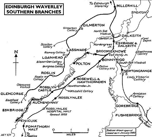
Ticket from Michael Stewart, Bradshaw from Chris Hind, route map drawn by Alan Young.
Sources:
To see other stations on the Glencorse branch click on the station name:
Millerhill, Loanhead, Roslin & Glencorse |

old3.jpg)


old1.jpg)
old2.jpg)
old8.jpg)
old6.jpg)
old5.jpg)
old4.jpg)
old7.jpg)

8.jpg)


chris_hind.gif)
old_thumb11.jpg)
old_thumb12.jpg)
old_thumb10.jpg)
old_thumb13.jpg)
old_thumb9.jpg)
thumb6.jpg)
thumb8.jpg)


 Home Page