Widnes Dock Junction was located at the southern end of the St Helens & Runcorn Gap Railway which had its official opening on 21 February 1833. The line ran between St Helens and the north bank of the River Mersey at Runcorn Gap where a dock, the Widnes Dock, built and owned by the railway was located. The junction itself was formed when the St Helens Canal & Railway Company (which came into existence in 1845 when the SH&RGR company merged with the Sankey Canal Company) opened lines to Garston (to Ditton from June 1851and to Garston from 1 February 1853) and to Warrington (to Whitecross on 1 February 1853 and to Warrington Arpley on 1 May 1854). The lines met end on at Widnes junction and crossed the original St Helens line on the level forming a flat crossing a feature that was never common in Great Britain.
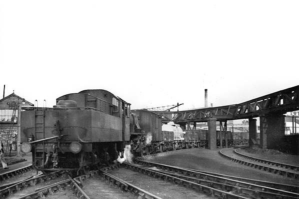
Widnes Dock Junction looking north on 10 November 1951. A goods train is seen coming off the Warrington line and heads onto the West Bank Dock line.
Photo by C H A Townley
Connecting spurs ran from the north of the flat crossing to the west, allowing trains to travel direct between Garston and St Helens, and from the east to the south, allowing trains to run direct between Widnes Dock and Warrington. Interestingly trains could not run directly between St Helens and Warrington. Both the through route between Garston and Warrington and the original St Helens line were double track when the junction was formed (the St Helens line having been doubled in 1850).
To the south of the flat crossing the line continued to Widnes Dock via the site of Runcorn Gap station (closed on 1 July 1852 when a replacement opened on the Garston line) and a swing bridge over the Sankey Canal which had reached Runcorn Gap only five months after the railway on 24 July 1833. Adjacent to the Widnes Dock were numerous sidings which later became known as Marsh sidings.
North of the flat crossing the line continued northwards to St Helens. West of the crossing at a distance of less than a quarter of a mile there was the Waterloo Level Crossing and to the west of that the replacement Runcorn Gap Station (renamed as Widnes on 1 September 1864). East of the flat crossing the line ran due east towards Warrington paralleling the Sankey Canal within a quarter of a mile.
The north to west connecting spur was initially a very tight radius but it was replaced in November 1856 with a curve that was much more gentle.
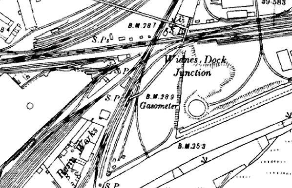
Widnes Dock Junction shown on an 1893 map. At this time the signal box was located on the east side of the St Helens line.
On 1 September 1860 the Garston and Warrington line was leased to the London & North Western Railway (LNWR) and on the 31 July 1864 the LNWR completely absorbed the St Helens Canal and Railway Company. By this time Widnes Dock Junction had become a serious constraint to traffic movements through Widnes especially because of the flat crossing. The LNWR invested £100,000 at Widnes to improve the situation with most of the money being spent on a new line the Widnes Deviation. The deviation line diverged from the Garston – Warrington line just under half a mile to the west of Dock Junction (at what became Widnes West Deviation Junction) and re-joined it just under a mile to the east (at what became Carterhouse Junction). It went north of the original alignment and passed over the St Helen line on a bridge. A spur also ran from the deviation to the St Helens line which allowed trains travelling between Garston and St Helens to use the deviation. The deviation opened on 1 November 1869 for goods services. On 1 March 1870 a new Widnes station opened on the deviation and all passenger services began to use it leaving Widnes Dock Junction with no passenger trains.
Widnes Dock Junction continued to be a busy location after the opening of the deviation as local goods services continued to run that way and by this time Widnes had developed into a major chemical manufacturing centre. Because the junction was so busy a footbridge was built that crossed over the north to west spur and the St Helens line after which it made a sharp turn and crossed the Garston – Warrington line to the east of the flat crossing. A right of access had existed down to the bank of the Sankey Canal and with the lines being so busy the LNWR wanted to stop pedestrians from crossing the line on the level. A further line had also opened from a new dock, West Bank, in 1862 which connected to the St Helens line just on the south side of the flat crossing and also had a connection to the Warrington line spur. A complex layout had been created and sidings were added along all of the lines.
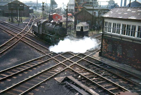
Looking southwest at the flat crossing that was part of Widnes Dock Junction c. mid 1960s. The original St Helens & Runcorn Gap Railway runs from the bottom right to the top left of the picture and the locomotive has just joined it. The other line that formed the flat crossing is the route that linked Warrington and Garston which opened to Garston in 1852 and Warrington in 1853. Widnes No. 4 signal box is seen to the right of the picture. Dock Junction itself closed in 1969 but some track remained in situ until the late 1970s.
Photo by Mike Humphreys
By 1879 the LNWR had opened a signal box at Widnes Dock Junction. It was replaced in February 1896 by Widnes No. 4 Dock Junction box. Located adjacent to the flat crossing on the north side of the Garston – Warrington line and the west side of the St Helens line it was an LNWR type 4 box with brick base and timber upper. The box had a 45 lever LNWR frame.
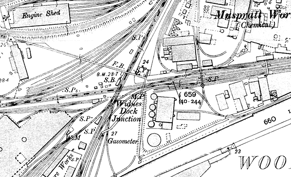
Widnes Dock Junction shown on a 1905 map. The 1896 signal box is clearly shown.
Little changed at Widnes Dock Junction until the 1960s. By 5 August 1967 little traffic was travelling down to Widnes Dock and the track layout had been simplified (although redundant track remained in situ). On that date a brake van railtour, the LCGB 'Warrington and Widnes Brake Van Railtour' visited dock junction. The railtour had started out from Earlestown. The locomotive was positioned on the actual flat crossing to allow photographs to be taken. It then drew forward towards Warrington before setting back onto the West Bank Dock line adjacent to the water tower where it took on water. The tour then headed east to Warrington.
On the 4 November 1968 the section of line from Dock Junction to Widnes Dock was taken out of use. On 10 March 1969 the original Garston and Warrington line between Waterloo Crossing and Widnes Dock Junction was taken out of use and the Widnes No 4 signal box was closed and all traffic running through Widnes had to use the deviation.
By 1970 most of the lines leading to Dock Junction had been lifted except for everything to the east of the flat crossing and a single line towards West Bank Dock. The footbridge and signal box were demolished section s of the bridge being left lying on the ground whilst the brick towers that had supported it remained in situ. What was left was interesting as sections of crossover and pointwork (clipped out of use) was left in situ on the single line section. The works to the east of the dock junction continued to be rail served from Carterhouse Junction until at least the mid 70s. Chemical wagons were often stabled on the single track spur.
In the late 1970s the Widnes Dock, Marsh Sidings and Widnes Dock Junction areas were developed into a public park called Spike Island. The last phase of the work was the Widnes Dock Junction area which was completed in 1983. All trace of the railway had gone by then other than the footbridge towers which were still standing. They were demolished at some point over the next decade.
In 2012 there was no trace of Widnes Dock Junction.
Sources:
- Industrial Railways of St Helens, Widnes and Warrington - Part 1 St Helens - C H A Townley and J A Peden - Industrial Railway Society - 1999
- The Sankey Canal and its environs in Halton - P T Wright - Halton Borough Council - 2010
- The St Helens Railway – J M Tolston – The Oakwood Press 1982
See also: Runcorn Gap, Ann Street Halt and Widnes (1st)
And Feature:
Widnes Locomotive Shed
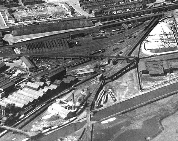
Widnes Dock Junction seen from the air in 1937.
Reproduced with the kind permission of Simmons Aerofilms Ltd
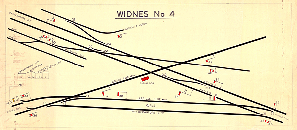
The track layout at Widnes Dock Junction as it was in the 1950s shown on a signal box diagram. To see the box diagram larger click here.
From the Brian Tighe collection
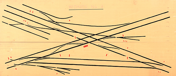
During the last few years the layout at Widnes Dock Junction was simplified as shown on this signal box diagram. By this time traffic was relatively light compared to the early 1960s.To see the box diagram larger click here.
From the Brian Tighe collection
To see more photos of Widnes Dock Junction click here.
|


 Home Page