RIVER DOUGLAS BRIDGE

[Source:Tony Graham & Paul Wright]

The River Douglas bridge was located on the West Lancashire Railway’s (WLR) Southport & Preston Railway that had opened in stages between 1878 and 1882. The bridge carried the WLR across the River Douglas at Hesketh Bank.

The WLR line from Southport had reached Hesketh Bank by 19 February 1878 but the bridge did not open until 18 May 1882 when the line was extended to Longton. (It finally opened to Preston on 5 September 1882.)  When it was first visited by the Board of Trade inspector in March 1882 it was refused approval.

The bridge was an iron structure of 24 cylindrical piles sunk 20ft into the river bed. The central group of piles formed a circle supporting a swing span that was a requirement to allow vessels to navigate the river. The span was worked by a water-powered hydraulic system.

The swing span was controlled by River Douglas signal box on the west bank at the station of that name. As a safety measure the signalling system was locked when the bridge was in the open position.

River Douglas station had been used by trains that had connected with the WLR-operated steamboat services, but it appears that it had not been used after the line had been extended to Preston. The bridge passed into the ownership of the Lancashire & Yorkshire Railway in 1897.

Having gone to the expense of providing a swing span it appears to have been little used and was fixed into position in September 1913.

The bridge continued to carry rail traffic until 6 September 1964 by which time it was part of British Railways London Midland Region. On 7 September 1964 the former WLR line closed between Hesketh Park and Penwortham Junction. The bridge was demolished after closure of the line and the only evidence of its existence in July 2011 was its stone abutments on each bank of the river and bases of the cylindrical piles on the river bank.

Sources:

See also: River Douglas station


A Southport-bound train crossing the River Douglas bridge c. early 20th century


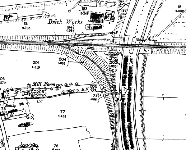
The River Douglas bridge on a 1:2,500 OS map from 1893. The bridge is described as a swing bridge which it was when the map was drawn. Seeing little river traffic it was welded shut in 1912.

A picture from the early 20th Century shows the River Douglas Bridge in the open position.

A Southport-bound train passing over the River Douglas bridge c. 1950s

The River Douglas Bridge seen the west bank of the river looking towards the north in October 1963. A Southport bound train is seen crossing with the locomotive being directly above the piles on which the bridge had originally swung.
Photo by B. Barlow

The River Douglas bridge looking north in August 1964 as a Preston-bound train crosses over. In the middle of the river the section on which the bridge had swung can be seen. It had however been fixed into position since 1913.

The site of the River Douglas bridge looking east in July 2011. The east bank abutment can be seen on the far side of the river.
P
hoto by Paul Wright

Looking north at the site of the River Douglas bridge in July 2011 from the west bank of the river. To the right the bridge abutment and the embankment of the WLR can be seen.
Photo by Paul Wright

The west bank abutment of the River Douglas bridge in July 2011.
P
hoto by Paul Wright


[Source:Tony Graham & Paul Wright]


Last updated: Thursday, 18-May-2017 17:22:32 CEST
© 1998-2011 Disused Stations