
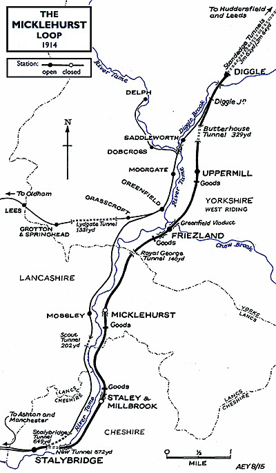
BRIEF HISTORY OF THE HUDDERSFIELD & MANCHESTER RAILWAY AND THE MICKLEHURST LOOPThe Micklehurst Loop was a double-track, 6¾-mile alternative route between Diggle and Stalybridge on the Huddersfield-Manchester line. The Loop straddled the borders of the West Riding of Yorkshire, Lancashire and Cheshire.
The route is still open today, carrying an intensive service of passenger and freight trains. It passes through a fascinating landscape, threading its way through steep-sided valleys, clad with stone-built cottages and terraces, and bleak moorlands rise to the horizon. The vistas are both rural and industrial, and many dark stone mills, some still with chimneys, are scattered across the valley floors. There are glimpses from time to time of the Huddersfield Narrow Canal and of the rivers Colne and Tame which drain the lofty Standedge plateau.
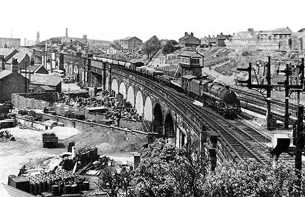
The stations between Huddersfield and Stalybridge were described by the Manchester Examiner as being ‘in the Tudor style’ and that they ‘will have a picturesque effect when completed; the pointed architecture harmonises so well with the abrupt pointed scenery around’. The dignified station buildings at Mossley and Saddleworth are still standing, but the finest station on the route is, without question, Huddersfield; the Classical frontage of the building is among the most impressive in Britain, colossal in scale and a reminder of the prosperity of the town in the mid nineteenth century.
THE MICKLEHURST LOOP
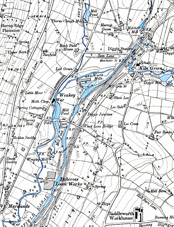
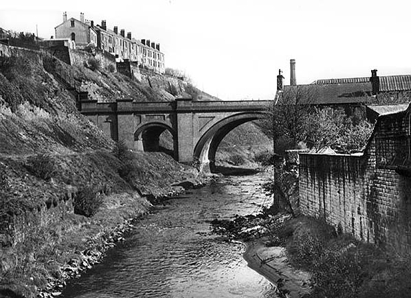
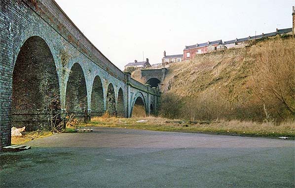
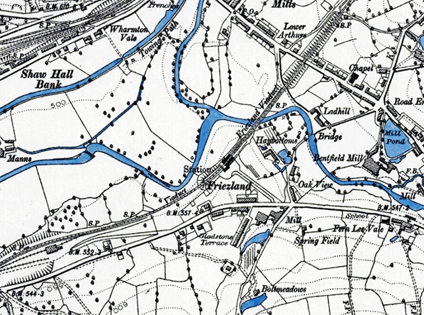
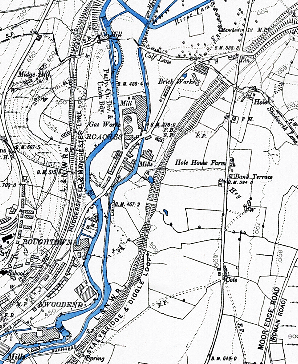
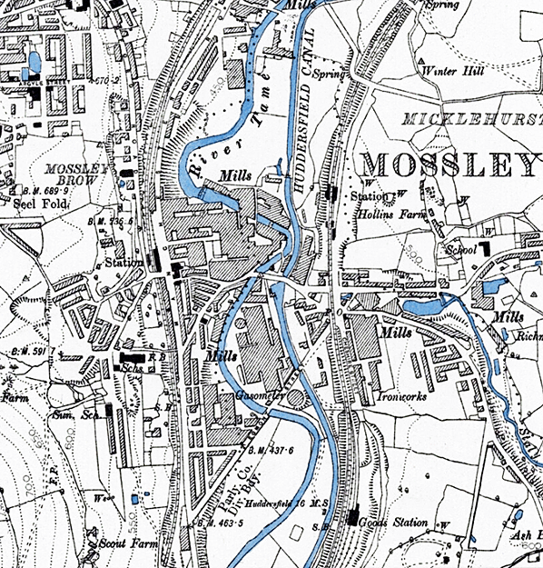
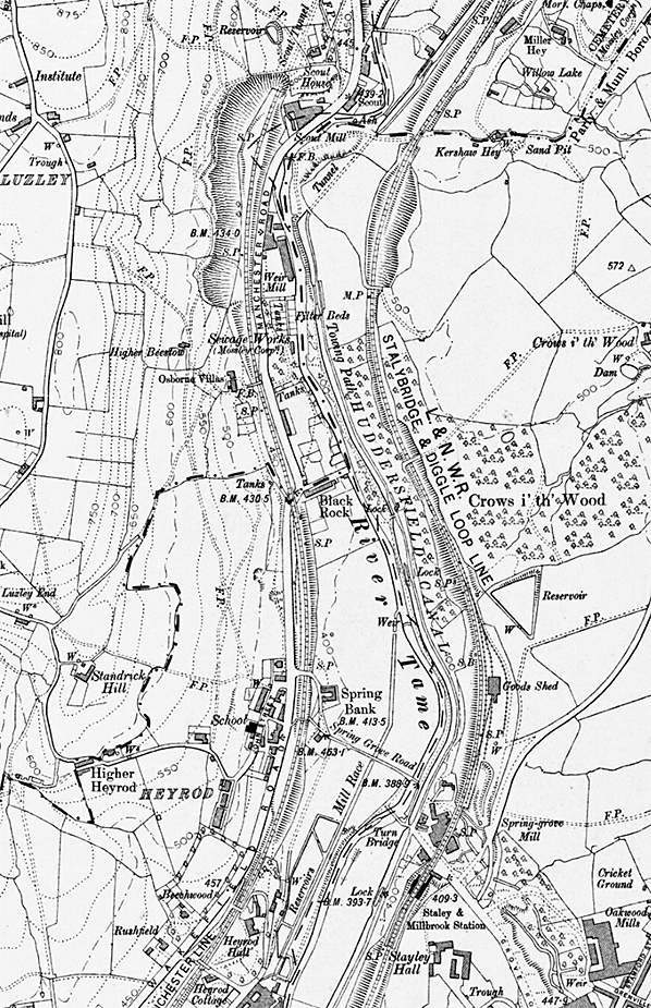
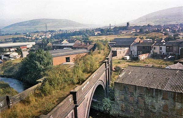
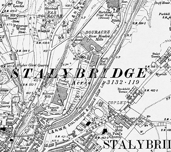
Between Diggle (immediately south-west of the Standedge Tunnels) and Stalybridge the railway clung to the steep western slope of the Tame valley, and industry and housing crowded the route so closely that it was impossible to squeeze two extra railway tracks into the space without extensive demolition and expensive engineering. The solution was to construct an entirely new 6¾-mile route on the eastern side of the Tame valley, with slightly less severe gradients, skirting the settlements which were already served by the stations at Saddlewoth, Greenfield and Mossley on the original line. Even this route involved some challenging engineering work. At the northern end of the loop was Butterhouse – otherwise known as Ryefield or Saddleworth - Tunnel (329yd); Royal George Tunnel (140yd) lay between Friezland and Micklehurst; and Stalybridge New Tunnel (c300yd), driven through Cocker Hill, was on the approach to Stalybridge. Immediately north-east of Friezland station was Greenfield Viaduct, confusingly named ‘Friezland Viaduct’ on OS maps; it was 242yd in length and possessed 16 arches, a large arch crossing Chew Brook. Friezland Viaduct was south-west of the station, with 12 arches and stretching 187yd. A further 243yd, 15-arch viaduct at Micklehurst over Staly Brook was immediately south of the station platforms. At the northern end of Staley & Millbrook station was Spring Grove Viaduct, consisting of seven arches and a lengthy metal girder span, which crossed the valley of Swineshaw Brook. Wells (1996) suggests that this viaduct impertinently sliced its way through the existing Spring Grove Mill, leaving buildings either side of four of the arches. A further viaduct was found immediately east of the Stalybridge New Tunnel. Prosaically described as Bridge No.3, but also known as Knowl Street Viaduct, it was a curving, blue-brick structure stretching some 330yd with 16 arches, striding across the River Tame, the Huddersfield Narrow Canal and three roads. The industrial nature of the valley demanded that goods depots and sidings be provided at intervals along the route. This required expanses of flat land which had to be created by cutting or tipping on the steep valley side – and none of the goods depots were adjacent to the four passenger stations. All of these engineering works ensured that the impact of the new line on existing industrial and residential buildings was kept to a minimum.
Although described as both the ‘Stalybridge & Saddleworth Loop’ and ‘Stalybridge & Diggle Loop’ on Ordnance Survey maps the line is more commonly known as the ‘Micklehurst Loop’. Royal Assent for the Micklehurst Loop was obtained by the LNWR on 17 June 1878. A previous Bill of 1877 had failed; if it had been successful there would have been much disruption of the urban fabric and street pattern of Stalybridge. Tenders for the line’s construction were advertised on 13 July 1881, and the successful bid was submitted by Messrs Taylor & Thompson of Manchester at £177,949 8s 2d, about £35,000 below the LNWR’s estimate of the cost of construction. During the construction process there were, as expected, some engineering setbacks and accidents and the customary outbreaks of violence involving the navvies. Uppermill was the scene of several unsavoury incidents involving navvies who were the worse for liquor, requiring attendance by the police. Local interest in the project was stimulated by the innovative practice of continuous construction work during the night, illuminated by powerful electric lights. The Oldham Chronicle reported on 4 August 1883 that work in the cutting at Greenfield attracted curious onlookers, one of whom likened the scene to the promenade at Blackpool.
Whilst the opening of many railway routes was the cause of celebration - local holidays being declared, special trains run for civic and railway company dignitaries and opportunities for feasting and consumption of much alcohol –it seems that the train service began on the Micklehurst Loop almost by stealth. Excitement was probably muted as each of the settlements through which the line passed already possessed a station on the original line. Wells (1996) remarks that acknowledgement of the work’s completion and the line’s opening was treated in a short, matter-of-fact manner, with no embellishment for the interested reader. Railway Times on 1 May 1886 stated clinically: ‘The LNWR Director’s Report stated that the Stalybridge and Saddleworth railway opened for through traffic on the 1st May 1886, the line being 6 miles 70 chains in length’. A week later on 8 May 1886 the Mossley & Saddleworth Reporter was rather more forthcoming about the occasion referring to the use of the new route experimentally by express trains during the previous week, following the running of goods trains along the route since the beginning of the year. The article noted that goods warehouses had been constructed at the - as yet, incomplete - intermediate stations. The same newspaper reported on 3 July 1886 that local passenger services had begun on the morning of Thursday 1 July, ‘and at the various stations on the route there was considerable competition as to who should produce the first ticket’.
The stations opened on 1 July 1886 were named Uppermill, Friezland, Micklehurst and Staley & Millbrook. However, three of them merely provided a second station for places which already possessed one on the original line. Uppermill station was ¾-mile from Saddleworth station, which was several hundred yards beyond the northern edge of Uppermill village but took its name from the parish. This station was briefly known as ‘Saddleworth Upper Mill’ in LNWR timetables until 1864. Uppermill station on the Micklehurst Loop was close to the centre of the village and much more conveniently placed than Saddleworth to serve it. In 1912 Uppermill gained a third station named Moorgate (sometimes suffixed ‘Halt’) on the original route although the only trains that called were those serving the branch to Delph. Friezland station was on the outskirts of Greenfield, but there was an indirect road route of over ¾-mile between this station and the existing one serving the somewhat scattered housing of the village. Micklehurst was an additional station for the town of Mossley; the original station was adjacent to the Town Hall and the main shopping street, whereas Micklehurst was just ¼-mile east and in a semi-rural setting on the edge of the town. Staley & Millbrook did not duplicate an existing station, but although it was conveniently placed for a nearby mill, there was little residential population within a mile of the station, and today it seems a curiously remote spot in an otherwise busy landscape.
An unusual feature of the Micklehurst Loop is that the four stations’ goods sheds and sidings were some distance from the passenger facilities; because the goods facilities at each station were extensive a precise distance from the passenger platforms cannot be stated, but at Friezland and Micklehurst the gap was in excess of ¼-mile. The goods warehouses at each station were notable for their generous size.
Although the Micklehurst Loop served several population centres, for the reasons given the local passenger train service soon proved to be little used and unprofitable, and the four intermediate stations were very early closures. The first to close to passengers was Micklehurst on 1 May 1907 followed by Staley & Millbrook, on 1 November 1909. The two remaining stations, Friezland and Uppermill were among the many casualties of war to close on 1 January 1917, as railway staff were released to serve in the forces. Many of these wartime closures were reversed from 1919 onwards, but Friezland and Uppermill did not reopen. The Micklehurst Loop remained important, however, for goods traffic and as the relief line for the route through Greenfield and Mossley, including use by excursion trains. Until summer 1958 an interesting oddity of the BR North Eastern Region timetable network map is that it showed the Micklehurst Loop, rather than the route through Mossley, as the principal one between Diggle and Stalybridge; a corresponding map in the London Midland Region timetable in 1956 gave priority to the Mossley route, but did show Micklehurst station as still open for goods traffic – the small scale of the map was probably the reason for the other three loop stations’ goods facilities not being shown.
All four of the former passenger stations on the Micklehurst Loop handled goods traffic until the 1960s. Micklehurst station was the first to close entirely (19 February 1962) followed by the other three, in quick succession: Staley & Millbrook (20 April 1964), Uppermill (15 June 1964) and Friezland (27 February 1965). The value of the loop line declined as freight switched to road transport and through goods movements were fewer, and in a climate of pessimism which seemed resigned to the shrivelling of passenger traffic, it was decided that double track would suffice for most of the Huddersfield-Manchester route. The Reshaping of British Railways (‘Beeching Report’) of March 1963 recommended that local passenger services on Huddersfield-Manchester route line should be withdrawn, with the closure of 13 intermediate stations (even Ashton) leaving Stalybridge as the only station. There was no reference to the Micklehurst Loop, but this apparent oversight was soon corrected. More than a year after its official closure to passengers on 7 September 1964, Hansard of 28 February 1966 reported that the Secretary of State for Transport, Mrs Barbara Castle, had provided a list of proposed closures and the progress made with enacting them. One of the entries in the list stated that the British Railways Board had given notice of a proposal to close ‘Stalybridge-Micklehurst-Diggle’ – with the footnote ‘added since publication of the Reshaping Report ‘ – and that no objections had been lodged to the proposal. In later years passenger use of the Loop was occasional, chiefly excursions and scheduled diversions, and the last passenger train to use the route was the Stephenson Locomotive Society's 'Pennine Rail Tour' (northbound) on Sunday 2 October 1966, the day before the line closed to through traffic.
The crass stupidity of all but annihilating the local Hudderfield-Manchester train service was reined in, and several of the stations, including Greenfield, Mossley and Ashton, are still open, while others such as Diggle and Saddleworth closed on 7 October 1968. Most of the four-track section between Huddersfield and Marsden was reduced to two tracks, and on 3 October 1966 the Diggle-Stalybridge section suffered similar rationalisation when the two tracks of the Micklehurst Loop were closed as a through route: both of the single-track Standedge Tunnels closed on the same day. About a mile of track at the southern end of the Loop remained in use to carry coals to Hartshead Power Station (a short distance north of the former passenger station of Staley & Millbrook and adjacent to its goods facilities).The remainder of the track was lifted by 1970. Coal traffic to the power station on the final, southern fragment of the Micklehurst Loop ceased in 1972, but it was not until 14 July 1976 that it was taken out of use and the points at Stalybridge were clamped. The power station closed in 1979. Knowl Street Viaduct (at the eastern portal of Stalybridge New Tunnel) was demolished in 1991.
THE FOUR MICKLEHURST LOOP STATIONS
VIADUCT NAMES Route map drawn by Alan Young Other web sites: The Micklehurst Loop - Numerous archive pictures along the loop. OS maps are 1:10,560. The first six are 1891-2 survey published 1895, the second two are a 1906-7 revision, published in 1911. BIBLIOGRAPHY:
To see stations on the Micklehurst Loop Line
|
 The route of the line from Huddersfield was through the Colne valley, west of the town, to the industrial village of Marsden beyond which it passed beneath the high Pennines at Standedge, where the Huddersfield Narrow Canal had already excavated a lengthy tunnel (3 miles 220yd) in 1811. The Standedge railway tunnel, 3 miles 62yd in length, was just one of the significant engineering challenges on the route, as there were also the Stalybridge (649yd) and Scout (220yd) tunnels, and substantial viaducts at Milnsbridge, Crimble, Slaithwaite, Uppermill and Stalybridge. Having crossed the watershed, the line emerged from Standedge Tunnel into the valley of Diggle Brook, a tributary of the River Tame. The route was laid as double track, though it was only single through Standedge Tunnel where sufficient land beyond each end was purchased should another bore to be made. On 13 July 1849 an inaugural train travelled from Huddersfield to Stalybridge and Manchester London Road (now Piccadilly), double-headed with 29 carriages and carrying 1,100 passengers. By way of celebration, the return journey halted at Diggle, immediately south-west of Standedge Tunnel, for the passengers to be treated to a picnic on a sloping field adjoining the railway. Regular services began on 1 August.
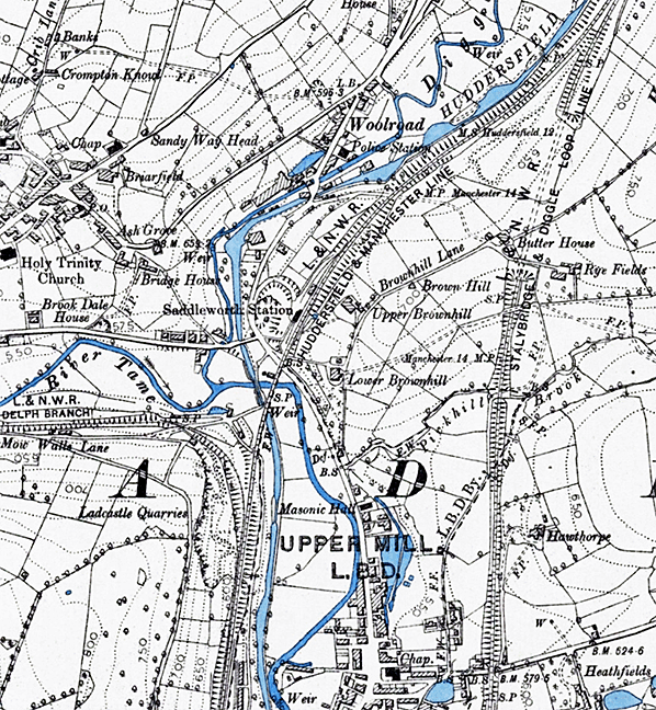

2a.jpg)

 Home Page