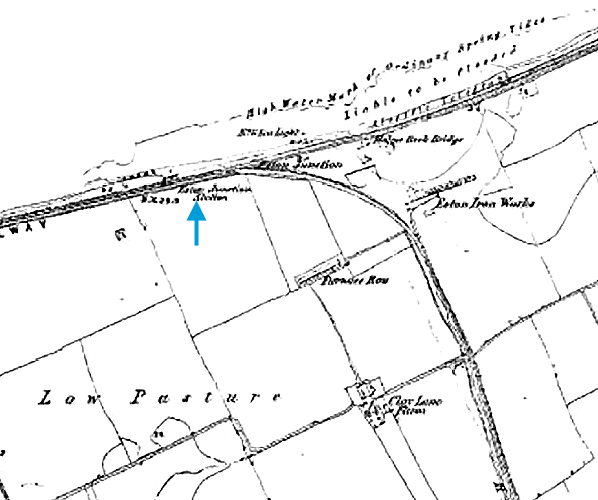
Notes: This station was originally known as Eston (or Eston Junction) and should not be confused with the station which replaced it c1866; or the station of the same name which was a passenger branch terminus from 1902 until 1929; or Eston Mines – a station on another branch which intermittently carried passenger traffic in the nineteenth century. Its precise date of opening is uncertain, but it first appeared in Bradshaw’s timetable in June 1853. Company records indicate that the platforms were not completed until June 1857. No details have been found of the buildings provided at this station. Map evidence seems to confirm that the station was re-sited about 150yd east following the acceptance on 16 November 1864 of tenders for a new station ‘near the junction’ (just east of where the Eston Mines branch left the Middlesbrough – Redcar route).
Map evidence suggests that the station was demolished at some time in the late nineteenth century, and alterations and additions to trackwork will have obliterated evidence of this station at that time.
It is not known if goods traffic was handled at the station.
 |
MIDDLESBROUGH AND THE SOUTHERN BANK OF THE RIVER TEES
South Bank is a little over two miles east of Middlesbrough on the railway to Redcar and Saltburn. At least three sites on this route have been occupied by stations known as South Bank. Although now a large town of over 140,000 inhabitants, Middlesbrough was a late arrival on the urban map of Britain. For centuries Stockton was the lowest bridging point and principal port close to the mouth of the River Tees. In 1811 Middlesbrough was little more than a hamlet, with 35 inhabitants, and by 1831 the figure was still only 154. The foundation of the town was prompted by opening of the Stockton & Darlington Railway (SDR) in 1825, the pioneering passenger and mineral line whose primary function was to carry coal from central and western County Durham to tidal water for export. At first Stockton was expected to suffice as the coal port, but it was soon evident that larger facilities closer to the sea were needed. Joseph Pease, a prominent figure in the Stockton & Darlington Railway and a member of the influential Quaker banking family, sailed up the Tees in 1828 seeking a site for new coal staiths. He persuaded the management of the S&D to extend the railway eastwards from Stockton, and by 1830 it reached the new staiths close to Middlesbrough Farm (almost directly north of the present Middlesbrough station). There was some debate about what to call this new port, which was at first known as Port Darlington; other options were Linthorpe, Leventhorpe, Acklam and Middlesbrough. A group of speculators, including Pease, set up the Owners of Middlesbrough Estate, and purchased 527 acres for the construction of a new town to service the port, on a site described by a contemporary reporter as ‘a dismal swamp’.
From the 1840s ironworks were established close to Middlesbrough, and the discovery of good quality ironstone in the Cleveland Hills near Eston several miles south-east of the town, prompted the rapid expansion of the industry along the southern bank of the Tees; a branch line from the Eston mines contributed traffic to the line through South Bank. In 1862 the Chancellor (later Prime Minister) Gladstone recognised Middlesbrough’s huge potential when he described the growing town as an ‘Infant Hercules’. By the 1880s there was an ironmasters’ district with a complex of furnaces, rolling mills, sheet mills, foundries, wire mills, coke ovens and concrete works served by an extensive and intricate network of railways. When steel supplemented iron production the local Cleveland ore was found unsuitable, so ore was imported from abroad, and this required additional docks and sidings. South Bank was in the midst of this industrial zone.
By the 1920s several miles of the southern shore of the Tees adjoining the Middlesbrough to Redcar line, on which South Bank station was situated, were lined with industry. Since WWI iron and steel had been joined by chemicals, originally at Billingham on the Durham (north) bank, but in the following decades oil refining and petrochemicals were added to the mix, and the Wilton plant, producing synthetic textiles, sprawled across an extensive site south of the railway several miles east of South Bank. This busy industrial region continued to grow in the 1960s as tidal mud banks of the Tees estuary were reclaimed for new factories and docks, and the author’s recollection of his first train journey between Middlesbrough and Redcar in 1963 was of a tormented landscape swathed in smoke and steam, a nauseous smell of sulphur, and huge expanses of sidings where steam locos were hauling and shunting rakes of wagons. Whilst de-industrialisation set in elsewhere by the 1970s, Teesside’s heavy industries battled on, and their thirst for water was a principal reason for damming the North Tyne, seventy miles away, to create Kielder Water reservoir (which inundated part of the former Border Counties Railway at Plashetts). In 1979 Britain’s last integrated steel mill - including Europe’s largest blast furnace - opened at the mouth of the Tees near Redcar. This necessitated the diversion of a stretch of the Middlesbrough – Redcar Railway and the construction of yet another complex of sidings. However, even as the new steel mill was under construction, Teesside was following the rest of the heavy industrial regions into rapid decline, and in the 1980s-90s many of the factories were abandoned. The scenes of dereliction along the railway route were as ugly as they were distressing. From the early 1990s, as work progressed to transform the Tees estuary from its grossly polluted state, reclamation was carried out of the derelict industrial land; a ‘flagship’ development on a brownfield site is the Riverside Stadium, home of Middlesbrough FC, which opened in 1995. However, much of the land adjoining the southern shore of the Tees remains bleak with industrial sites scattered around the open spaces which are still waiting to be used. The recent recession has hit Teesside badly, and the prospects for further developments to improve the economy and aesthetic appeal of the southern bank of the Tees in the near future look gloomy.
BRIEF HISTORY OF THE MIDDLESBROUGH & REDCAR RAILWAY
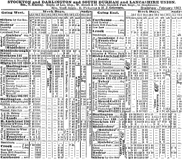
The Middlesbrough & Redcar Railway, authorised by an Act of 21 July 1845, opened to passengers on 5 June 1846, but from the outset the line was an important goods route. The first train was hauled by Locomotion No 1. The original Middlesbrough station was replaced with a new facility the following year, and the present station opened in December 1877. The line was leased to the SDR on 1 October 1847 and formally amalgamated with this company on 30 June 1862. In turn, the North Eastern Railway (NER) absorbed the SDR on 13 July 1863. At the eastern end, the original terminus at Redcar was replaced on 19 August 1861when the line was extended to Saltburn. In the late nineteenth century Redcar, Marske and Saltburn developed as holiday resorts, serving as playgrounds for the burgeoning population of Middlesbrough and its conurbation, but they also aspired to attract visitors from further afield.
The route of the Middlesbrough & Redcar Railway was on the flat land south of the Tees, within a mile of the river bank, the steepest stretch of the line being a rise at 1in 242 on the approach to Redcar. Stations on this line present a challenge to railway historians, as some of their dates of opening are difficult to establish, some were probably or definitely re-sited, and names were changed and even exchanged between stations: South Bank was one such location.
In 1861 a mineral line opened from Normanby Jetty on the Tees, a short distance north-west of South Bank to Normanby mines and beyond, with a link built from the Middlesbrough – Redcar line in 1865. On 1 January 1902 a passenger service was introduced on this line from Middlesbrough to a new terminus at Eston; this branch was remarkable in having no intermediate stations in the three miles between Cargo Fleet Junction and Eston. The passenger service to Eston lasted only until 11 March 1929, a casualty of motor bus competition.
Bradshaw from Alan Young. Route map drawn by Alan Young.
Sources:
- Bragg, S and Scarlett, E North Eastern lines and stations (NERA 1999)
- Cook, R A and Hoole, K North Eastern Railway historical maps (RCHS 2nd edition 1991
- Fawcett, Bill A history of North Eastern Railway architecture (Three volumes) (NERA 2001-05)
- Godfrey, Alan Middlesbrough 1913 and North Middlesbrough 1913 Old Ordnance Survey Maps: historical essays (Alan Godfrey 1987 and 1988)
- Hoole, K Railways in Cleveland (Dalesman 1971)
- Hatherley, Owen A new kind of bleak: journeys through urban Britain (Verso 2012) Chapter 2 reviews the post-industrial landscape and architecture of Teesside.
- Quick, Michael Railway Passengers Stations in England, Scotland & Wales (RCHS 2009)
- Tomlinson, W W The North Eastern Railway: its rise and development (David & Charles reprint 1967)
- (Middlesborough) Gazette Live web site
See also: Cargo Fleet, South Bank (2nd site), South Bank (3rd site)
& Eston (2nd site)
|


 Home Page