
Cambridge - Its Railways and Station[Source:
Darren Kitson]
Part 11: Getting to and from the Station When talking about railway stations in the historical context we tend to focus upon architecture, facilities and the trains whilst giving little thought to the various ways and means by which passengers got to and from stations over the decades. We will attempt to remedy this here and also use the opportunity to describe the station yard area and some of its features.
The above image is c1908. At this time horse-drawn road transport still predominated and at least two of the vehicles seen are hackney carriages. The gas lamps in the arches were installed around this time but the awning over the entrance has yet to appear. Public lighting in Cambridge remained predominantly gas until as late as 1955 when trials with electric lighting were made along King's Parade with British Thomson-Houston equipment, yet some gas lighting remains in the city to this day. There was something reassuring and almost homely about gas lighting, but it was just about bright enough to see where you were going and that was it. In 1908 the large open space in front of Cambridge station would have been quite gloomy at night, so the twelve gas lights in the arches must have made a welcoming sight as people approached along Station Road and especially during winter. As well as being of benefit to cab drivers and passengers, the lights would also illuminate the many advertisements inside the colonnade. One promotes the Great Eastern Railway's 'Express Service to North Germany' while another boasts about a destination (unknown) 3½ hours away from Cambridge by train. The Germany offering would, by 1908, have been from Harwich via a GER steamer to the Hook of Holland and the relevance of North Germany would simply be because that was the quickest part of Germany to reach by land and sea via GER services. The 3½ hour journey probably refers to the York service which by that time was running from London via the GN&GE Joint Line, the final section [between Ruskington and Pyewipe Junction] of which had opened in August 1882, and used GER locomotives throughout. A Midland Railway board is also just visible in the colonnade and it is likely the LNWR also promoted its offerings on another board. Until 1910 the GNR kept itself to itself in its own station building, so their advertisements were probably displayed there.
The above image is undated but is c1912. By this time the awning has appeared; GER records show discussions concerning the provision of this awning rambled on for quite some time and it appears cost was a major issue. Some of the arches have been enclosed and this was done to extend office accommodation (today these arches, north of the entrance, contain the station refreshment room) while some of the gas lights have accordingly been removed. The horse-drawn cab of the Bull Hotel can be seen; such cabs and buses were a common sight at one time and a few still exist, usually being minibuses or so-called 'people carrier' type vehicles. Motor vehicles are now beginning to appear and two motorcars are visible but are too far away to tell what they are for certain. Also visible are two bicycles, a hint of things to come, while on the left is an Ortona double-deck bus on Service 1 to Chesterton. 'Ortona' was a rather odd name for an omnibus company; in August 1907 the by-then-defunct Cambridge Motor Bus Co. was taken over by Mr J. B. Walford who had taken a liking to the Italian town of Ortona while on a cruise and so he named his company after it. Ortona service 1 terminated originally at De Freville Avenue, in an area of Cambridge known as New Chesterton. In 1931 Ortona was one of the companies which merged to form the Eastern Counties Omnibus Co. and the last ex-Ortona buses, bearing Cambridge VE registration numbers, managed to survive into the 1950's as members of Eastern Counties AH Class Leyland Titans. We must not forget another means by which people could travel to and from the station between 1880 and 1914. This was the horse-drawn trams of the Cambridge Street Tramways Co. The tram terminus was off to the left of the above image and consisted of nothing more than a single track ending abruptly in the middle of Station Road opposite the station entrance. Station Road did not exist prior to the coming of the railway and until 1859 was a rough, unmade track belonging, apparently, to the railway company. In that year it was repaired and transferred into public ownership; to the council, in other words. The Cambridge tramway was 4ft gauge and operated over two routes; East Road to the Market via Lensfield Road and Trumpington Street and from the railway station to the Post Office via Station Road. Hills Road, Regent Street and St Andrew's Street. The two routes crossed at the Catholic Church junction, known locally as 'Hyde Park Corner'. The depot was on East Road and is now a pub / restaurant, having been used for a number of purposes in the interim, most notably as a store for Peak's Furnishings. Only eight tramcars were ever owned, a mix of single and double-decked. One of them originally operated in Bath before moving to Bradford (the Bradford & Shelf Tramway) and then to Cambridge as car No.7. Originally a single deck car, it has survived into preservation and at the time of writing is at the Ipswich Transport Museum.
The above image, photographer unknown, is of poor quality but the number on the tram's dash appears to be '2'. Enough information regarding construction details of the Cambridge trams has survived for us to determine that this is indeed car No.2. It was supplied new to Cambridge by the Starbuck company but as a 24-seat single deck vehicle, being converted to double-deck at an unknown date and in which form it seated 42 passengers. The date of the photograph is not known but other details suggest it was taken shortly before the tramway closed on 18 February 1914. The livery of the trams was red and cream. A document dated 1899 survives in the Cambridgeshire Archives giving details of proposed tramway extensions and electrification. The details are too complex to elaborate here but suffice to say some extensions were short stubs added to the existing routes while others were in effect extra routes; Station Road Corner to Cherry Hinton Road / Blinco Grove; East Road to Newmarket Road / River Lane and St Andrew's Street via Parkside and Mill Road to Romsey Town, terminating at what is today Cyprus Road. Generating stations were to have been at Hooper Street and East Road. Among the list of short stub extensions was one from the existing Station Road terminus into the railway station. Quite how this was to be achieved is not known and to date no GER records have come to light which mention it. Obviously, the extensions and electrification were never to be. It is said the university blocked the proposals, citing 'unsightly' overhead wires as the reason (in London, a similar objection resulted in trams collecting current via the conduit system in the central area). These objections seem rather strange when we consider Victorian streets stunk from horse muck and other objectionable things while the early petrol-engined motor buses were smokey, relatively noisy and could backfire as they tore along at the then-permitted breakneck speed of 12mph. Cambridge had become familiar with motor buses from as early as 1905, with Ortona being formed in 1907. Its extension and electrification plans thwarted, the Cambridge Street Tramways continued to clip-clop along with horse traction until the 1914 closure, by which time the motor bus, as crude as it then was, had become well established.
The above view appears in a small number of publications and is usually dated c.1950 The car in the right foreground is a Vauxhall Velox Series EIPV, this variant being introduced in April 1952 and a check of the car's registration number tells us this example was registered in June 1954 so that is the earliest date which can be attributed to this photograph. In the right background either a Daimler Conquest or a Lanchester Fourteen (same car, different marque) can be seen . This was a somewhat upmarket car in its day and the example seen above perhaps belonged to a London commuter. In the centre of the row of three cars behind the Vauxhall is a Jowett Javelin, while at centre right can be seen a Morris Minor; either a Series MM or Series II. Most of the other cars in the background are taxis and the Hackney plate is just visible on some of them. In the distance the bus terminus can be seen. The double decker nearest the Camera is an Eastern Counties Bristol K type with 7ft 6in body. It is on Service 101 to Green End Road and will travel via Station Road, Hills Road, Regent Street, St Andrew's Street, Sidney Street, Bridge Street, Magdalene Street, Chesterton Lane, Chesterton Road and Chesterton High Street. Service 101 began life as Ortona Service 1 and continued to run, with minor route variations, renumberings and extensions at the Chesterton end until relatively recently.The very last 7ft 6in Bristol K in the Eastern Counties fleet, HPW 135 (Fleet Number LKH 135) was at Cambridge, finally bowing out in June 1970 having just outlived the penultimate example, LKH 136. The single decker bus is a Bristol L type and is most likely operating as a relief bus on the 101 route, a common occurrence at one time. The other double decker hiding in the corner is probably a United Counties example on the service from Bedford. In 1952 United Counties took over from Eastern National what the latter misleadingly called their 'Midland Area' (actually Buckinghamshire, Bedfordshire, Hertfordshire and south-west Cambridgeshire) and at that time the Cambridge - Bedford service was numbered 149. In 1958 the 149 was merged with the 128 which then ran between Cambridge and Northampton. For many years thereafter, the 128 was the longest stage carriage bus route in the country. It operated within Cambridge via Hills Road, Lensfield Road, Queens Road and what was once the A45 towards Eltisley and St Neots and did not serve Cambridge city centre. When the Cambridge - Bedford railway closed at the end of 1967, the 128 did not double-up as the rail replacement bus service. That honour fell to the 428 which was introduced for the purpose. The 428 was slow, meandering and poorly patronised as was the case with many rail replacement bus services. It was withdrawn after a very short life. The bus terminus at Cambridge station was sited, as in the photograph, at the front of the former Great Northern Railway station until being relocated onto Station Road, opposite the station entrance, during the 1970s. Note that part of the colonnade has been enclosed and the advertisements inside the colonnade seen in earlier photographs have disappeared. Note, too, the lack of bicycles - a situation very different to today. The colonnade, incidentally, was originally intended for use by cabs but with the station entrance located at its mid point it is hard to see how this could have been practical. In any event, until offices were extended into the colonnade and it became enclosed its main use appears to have been the storage of luggage trolleys.
In the May 1970 image above not a great deal has changed from the 1950s image. The telegraph poles have gone, floodlights have appeared on the roof but that is about it. The cars are very period and consist of BMC and Rootes group models. Sharp eyed readers will have noticed one of the arches which had been enclosed has been opened up again, as it had in the 1950s image, while others at the south end have been enclosed.
Taken around the same time as the previous image, we can see the station frontage taken from the same spot as the earlier image of the tram. The building on the extreme right is the former Station Hotel. Outside the station are the usual, for the time, Pininfarina-styled Austin Cambridge and Morris Oxford taxis of Camtax and United Taxis although the car behind the light coloured taxi in the centre of the image appears to be a Wolseley 6/110. The Pininfarina Austin Cambridge and Morris Oxford were practical and comfortable cars; one did not need to be a contortionist to sit in the back, nor did one feel one was thudding down almost onto the road surface when getting in. The cars of Camtax and United Taxis must have taken millions of people to and from Cambridge station over the years. In the foreground we can see a moped with perspex windscreen; something else one no longer sees. Behind the moped is a Triumph 1300 while on the left, spluttering off along Station Road, is a convertible Volkswagen Beetle. Unless an aftermarket conversion, convertible Beetles were all left hand drive imports. Today, where the cars are parked is a row of bus stops while the rest of Station Road is double yellow lines, a taxi rank and some Pay & Display parking. When one has to pay Vehicle Excise Duty (car tax) to keep a vehicle on the road in the first place, having to pay more simply to park at the side of the road is hard to swallow.
Above is the station frontage in July 2008. The entrance is asymmetric, using the northernmost pair of the original three entrance arches. The booking office is behind the two arches above the blue taxi.
Above is a July 2009 view taken further back and from the bus stop area which replaced that seen in the 1950s image. The tram terminus used to be where the triangular road marking now is, between the two cars. On the extreme right is a modern building on the site of the former Station Hotel. A sightseeing open-top bus can also be seen; these now run regularly whereas at one time sightseeing tours were half-hearted affairs run by small local operators such as 'Paddy' Harris's Progressive Coaches.
Above is another view of the post 1970s bus stop, this time with the station behind the photographer and the date is January 1980. The bus is Bristol Lodekka FS5G LFS 126 (GNG 126C) and was the last of the FS type to be purchased by Eastern Counties. LFS 126 was withdrawn the same year it was photographed and the type had left the Eastern Counties passenger fleet by 1982 although LFS 86 was to reappear later under Cambus auspices. As already mentioned, Ortona service 1 became the 101 under Eastern Counties and following a route reorganisation c1974 it became routes 180 and 181. The 180 was a variation which deviated from the main route in Chesterton to serve the Fen Estate; a pleasant area near the river and off the road which crossed the railway at Chesterton Junction. Today, the buses in Cambridge are mainly operated by Stagecoach and complete route reorganisations have taken place. The modern building in the left background, above, was Great Eastern House; the offices of the one-time Area Manager before the lines north of Cambridge came under the rule of the Divisional Manager, Norwich. Great Eastern House was demolished in 2011, having stood empty and boarded up for some time.
Also in January 1980, United Counties Bristol VR 791 leaves Cambridge station on the 128 service to Northampton. In the right background part of the now-demolished Station Hotel can be seen, while a modern British Rail sign with double arrow logo adorns the station building having replaced the earlier 'British Railways Cambridge' signage. Nowadays, with train operators changing every five minutes, erection of these large and informative signs which were visible from a distance is not bothered with other than at major stations managed by Network Rail. United Counties did not use class codes on their buses, just plates bearing the fleet number. These plates were coloured according to depot; that on 791 informing us the bus was based at Bedford.
Above is the former bus stop area as seen in the 1950's image, south of the main building and with the former GNR station off the image to the right. In July 2008, when the picture was taken, this area was being used by a car rental firm. Note the plaques on the wall to the right; these lurk all around the station and you never know where you might find one next!
This July 2008 view is looking south across the area generally known as the station yard. Behind the trees on the left the blue doorway in the previous image can just be seen. The photographer is standing with his back to the former engine shed stores. In the centre the former GNR station can be seen, with its monstrous carbuncle extension on its west face. The car park is a relatively recent addition, while the area is becoming decidedly leafy. In the right background Cambridge PSB (Power Signal Box) can be seen ; the area now being completely built-up and with the lead-in road to the southern section of the guided busway running through it. The busway runs between the PSB and the railway tracks before passing beneath Hills Road via a purpose built additional span in the bridge.
Also taken in July 2008, this view is looking north with the station building off to the right. The trees are those seen in the previous view. The GER shed stood ahead and to the right and the buildings with the large sign are the former shed stores. Today, the site of the shed is the station's main car park which extends around the west side of the former stores building (See Part 2). As the sign suggests, bicycles are big business in Cambridge and currently provision for the parking of some 3,000 bicycles is provided at the station.
Another from July 2008, the above view is looking north from the south end of the station. In the distance the large white sign in the previous image can be seen. The former Foster's mill is seen on the left and on the right the former GNR station building is seen, by now with a compound added to its monstrous carbuncle extension. The mill was once served by a siding and there was an awning over the loading bay where the cars are parked on the left. If you enjoy shocks, see the image below.
Taken from a little further south, this is the scene in August 2012. Platform 3 of the station is off to the right and in the right distance the roof of the former GNR station building can be seen. In the centre the modern rendition of the former Foster's mill is seen. It had been intended to retain the mill building almost in its entirety as part of the CB1 development (the CB1 title comes from the relevant Postcode area) but the building was damaged by fire during construction work in 2010 so only a part of it now remains. Foster's mill dated from 1898 and replaced the original granaries on the site. It went under a variety of names over the years as ownership changed; Foster's; Homepride; Rank-Hovis-McDougall and Spillers. The Foster family were primarily bankers and they opened a bank in Cambridge city centre largely and originally for the convenience of their many employees. The building is still in use today as a branch of Lloyds Bank and sits in the 'V' of the Sidney Street/Hobson Street junction. The Foster's name can still be seen in the stonework above the bank's Sidney Street entrance. Returning to the image, the new building on the left stands on the site of the former Spillers Research laboratories which can be seen in numerous images looking from Hills Road bridge. The roadway seen above runs into the guided busway behind the photographer to reach Addenbrooke's Hospital and Trumpington. The two buses will not be operating to / from this section of the busway as it is restricted to single-deck vehicles. The busway between Addenbrooke's and Trumpington is single track as it runs through the curving cutting of the former LNWR Bedford line, the section being controlled by conventional traffic signals. It will be noted that the bus stops seen above are not especially well sited for the railway station, although some are closer. The image also illustrates a further problem with the guided busway; this being that buses have to negotiate much of Cambridge on conventional roads although bus lanes and restrictions to other vehicles have eased this problem somewhat. Whether one is pro-busway or not, it has meant former railway routes remain as dedicated public transport corridors rather then being ploughed back into the fields or built on. Calls to reopen the Bedford - Cambridge railway have been heard for many years and currently it is planned as part of the so-called 'East - West Rail' project. Despite this, the busway has been allowed to encroach upon part of the route so this, and other supposedly insurmountable obstacles, mean any new Bedford - Cambridge railway will likely take a rather circuitous route running further south
Above the demolition of the public entrance to the former Great Northern Railway goods and coal yard in March 2010 can be seen. The location is the junction of Hills Road and Brooklands Avenue, opposite the former LNWR goods station seen earlier. This goods yard should not be confused with the GNR goods shed on the opposite side of the railway. For many years the GNR goods yard was used for overflow parking of Eastern Counties buses, with some track and wooden buildings intact. The area is now covered by the CB1 development and a road now bisects the site.
Above is the same view on 25 March 2012. Building work is still ongoing and the ground floor of the new building now contains shops. The new road on the right, Brookgate, takes buses to and from the railway station and avoids doubling back along Station Road as was previously the case. The double-bay building to the immediate left of the new structure is the only surviving ex GNR building at the former goods depot site. It is visible in both the above images. Click here for Part 12: Acknowledgements, sources and references or return to Cambridge home page
|
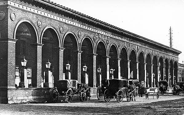
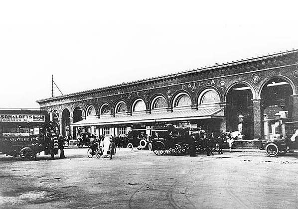 Photo from John Mann collection
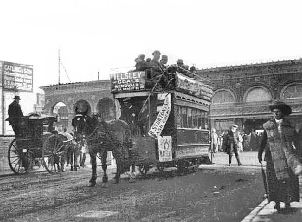 Photo from
 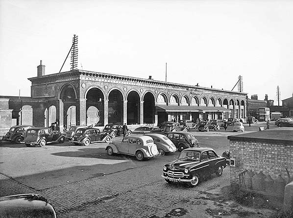 Photo from John Mann collection
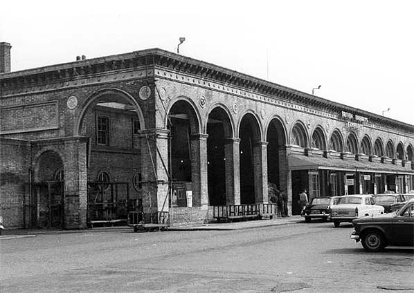
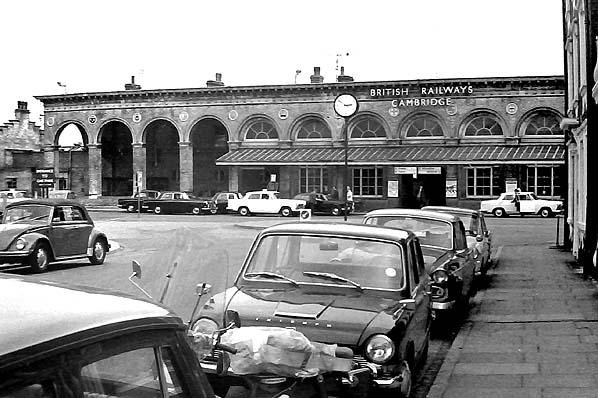 Photo by
 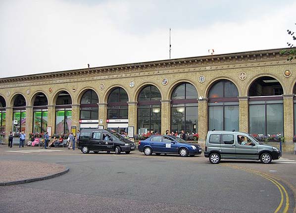 Photo by Sebastian Ballard reproduced from
 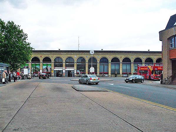 Photo by Sunil Prasannan reproduced by
 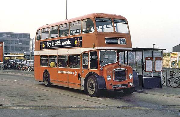 Photo Martin Addison reproduced by
 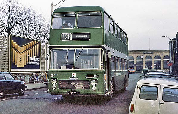 Photo Martin Addison reproduced by
 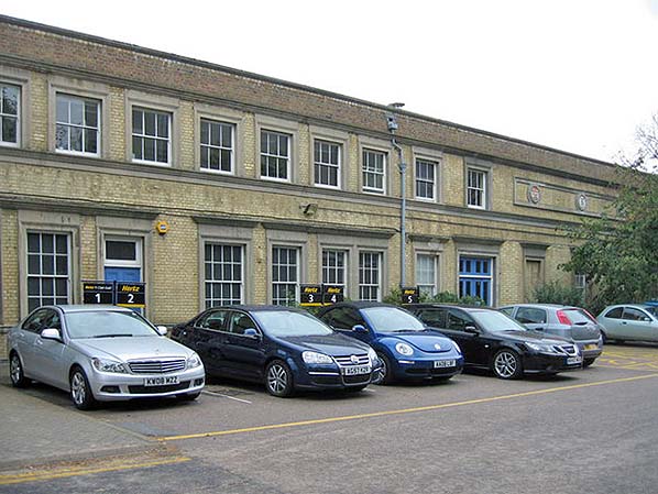 Photo by Sebastian Ballard reproduced from
 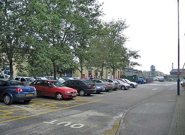 Photo by Sebastian Ballard reproduced from
 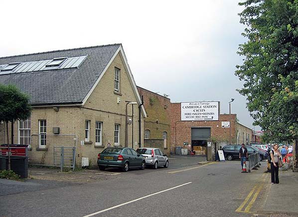 Photo by Sebastian Ballard reproduced from
 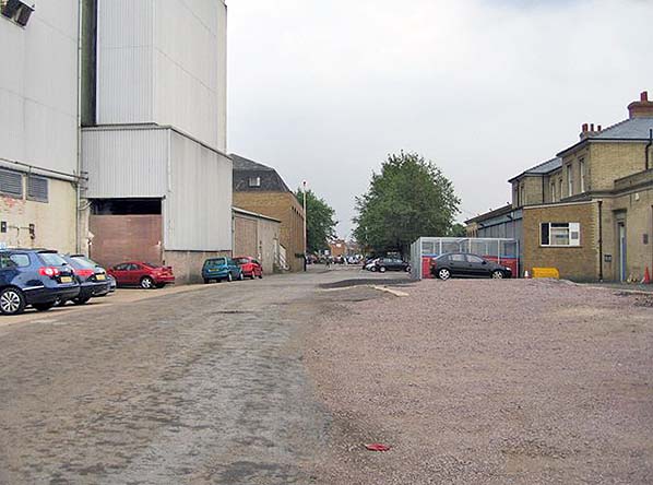 Photo by Sebastian Ballard reproduced from
 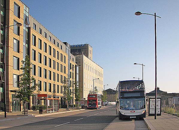 Photo by John Sutton reproduced from
 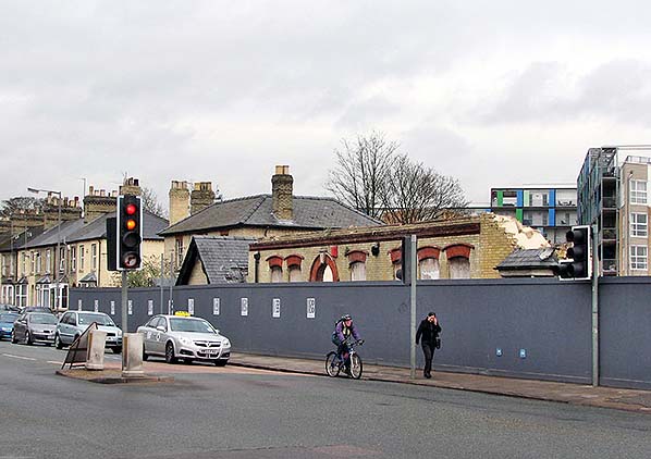 Photo by John Sutton reproduced from
 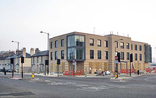 Photo by John Sutton reproduced from
 Home Page